Property Record
Walnut Grove Rd, Cartersville, GA 30120

NEARBY LISTINGS FOR SALE OR LEASE
Property Detail
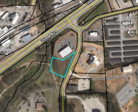
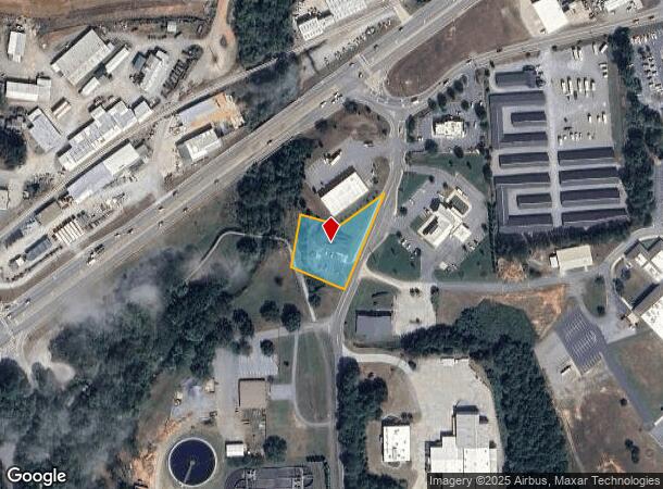
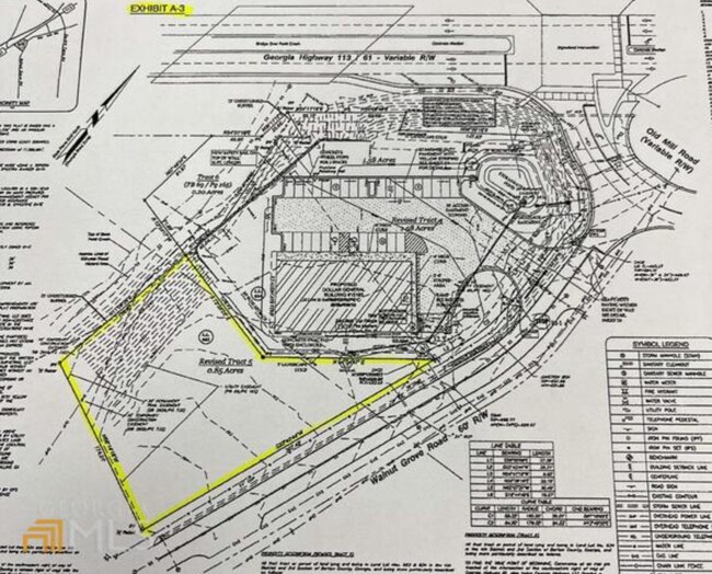
Walnut Grove Rd
Atlanta-Sandy Springs-Roswell, GA
Com - West/Highway 113
C074-0001-006
LL 634/663 LD 4 TRACT 4 PLAT BOOK 69 PG 165
Commercialacreage
Bartow
X
Georgia
13015C0264H
4
2024
0.86 AC
2025
Bartow County
960902
Atlanta
DEMOGRAPHICS near Walnut Grove Rd
1 Mile
3 Mile
5 Mile
2024 Total Population
2,261
22,497
47,163
2029 Population
2,484
24,657
51,603
Pop Growth 2024-2029
+ 9.86%
+ 9.60%
+ 9.41%
Average Age
39
39
39
2024 Total Households
892
8,432
17,699
HH Growth 2024-2029
+ 9.64%
+ 9.37%
+ 9.15%
Median Household Inc
$65,658
$72,043
$70,032
Avg Household Size
2.40
2.60
2.60
2024 Avg HH Vehicles
2.00
2.00
2.00
Median Home Value
$319,556
$256,977
$235,669
Median Year Built
1991
1988
1989
Nearby Places
Map Layers
Map Styles
 Street
 Aerial
- Restaurants
- Banks
- Shops
- Fitness
- Groceries
SALE & LEASE HISTORY
LISTING DATE
SALE/LEASE

May 22, 2019
For Sale
Feb 21, 2022
For Sale
Nearby Properties
Address
Land Use
TOTAL SIZE
Lot Size
Zoning
Address
Land Use
TOTAL SIZE
Lot Size
Zoning
1,200 SF
25.69 AC
IN
Address
Land Use
TOTAL SIZE
Lot Size
Zoning
226,108 SF
33.73 AC
Address
Land Use
TOTAL SIZE
Lot Size
Zoning
196,710 SF
149.63 AC
Address
Land Use
TOTAL SIZE
Lot Size
Zoning
104,757 SF
45 AC
IN
Address
Land Use
TOTAL SIZE
Lot Size
Zoning
149,158 SF
46.23 AC
IN
Address
Land Use
TOTAL SIZE
Lot Size
Zoning
Address
Land Use
TOTAL SIZE
Lot Size
Zoning
134,528 SF
4.71 AC
IN
Address
Land Use
TOTAL SIZE
Lot Size
Zoning
Address
Land Use
TOTAL SIZE
Lot Size
Zoning
1,800 SF
102.03 AC
A1
Address
Land Use
TOTAL SIZE
Lot Size
Zoning
Address
Land Use
TOTAL SIZE
Lot Size
Zoning
88,974 SF
5.42 AC
IN
Address
Land Use
TOTAL SIZE
Lot Size
Zoning
24,991 SF
25.20 AC
Address
Land Use
TOTAL SIZE
Lot Size
Zoning
29,629 SF
21.90 AC
IN
Address
Land Use
TOTAL SIZE
Lot Size
Zoning
57,164 SF
4.88 AC
Address
Land Use
TOTAL SIZE
Lot Size
Zoning
470,504 SF
22.66 AC
IN
Address
Land Use
TOTAL SIZE
Lot Size
Zoning
66,606 SF
6.74 AC
IN
Address
Land Use
TOTAL SIZE
Lot Size
Zoning
34,786 SF
12.23 AC
IN
Address
Land Use
TOTAL SIZE
Lot Size
Zoning
Address
Land Use
TOTAL SIZE
Lot Size
Zoning
7,763 SF
14 AC
IN
Address
Land Use
TOTAL SIZE
Lot Size
Zoning
170,445 SF
6.12 AC
IN
Address
Land Use
TOTAL SIZE
Lot Size
Zoning
128.74 AC
A1
Address
Land Use
TOTAL SIZE
Lot Size
Zoning
61,132 SF
5.39 AC
Address
Land Use
TOTAL SIZE
Lot Size
Zoning
92,072 SF
11.77 AC
IN
Address
Land Use
TOTAL SIZE
Lot Size
Zoning
189 AC
A1
Address
Land Use
TOTAL SIZE
Lot Size
Zoning
24,850 SF
4.12 AC
IN
Address
Land Use
TOTAL SIZE
Lot Size
Zoning
Address
Land Use
TOTAL SIZE
Lot Size
Zoning
211,879 SF
23.57 AC
IN
Address
Land Use
TOTAL SIZE
Lot Size
Zoning
13,784 SF
5 AC
IN
Address
Land Use
TOTAL SIZE
Lot Size
Zoning
67,579 SF
18.97 AC
IN
Address
Land Use
TOTAL SIZE
Lot Size
Zoning
2,632 SF
52.90 AC
IN
The World's #1 Commercial Real Estate Marketplace
Connect with us
© 2026 CoStar Group
The information above has been obtained from sources believed reliable. While we do not doubt its accuracy we have not verified it and make no guarantee, warranty or representation about it. It is your responsibility to independently confirm its accuracy and completeness. Any projections, opinions, assumptions, or estimates used are for example only and do not represent the current or future performance of the property. The value of this transaction to you depends on tax and other factors which should be evaluated by your tax, financial, and legal advisors. You and your advisors should conduct a careful, independent investigation of the property to determine to your satisfaction the suitability of the property for your needs.