Property Record
Walnut St, Coshocton, OH 43812
Property Detail
Walnut St
Coshocton, OH
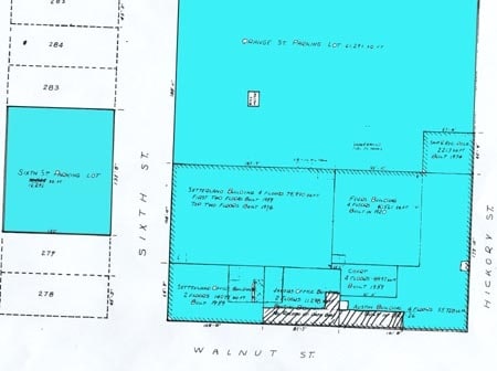
IN-LOT 254 253 S PT 50 X 75.5 255 S PT 43 X 75.5 04 DOC 3557
04300-003-699-00
COSHOCTON
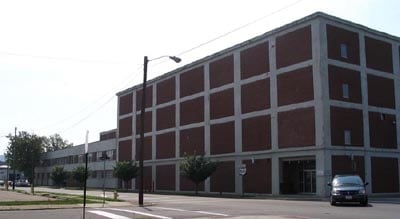
Parkingstructure
Ohio
B and X Area of moderate flood hazard, usually the area between the limits of the 100-year and 500-year floods.
254
2025
0.16 AC
2025
Other Market Areas
961400
NEARBY LISTINGS FOR SALE OR LEASE
-
-
View all Coshocton listings for sale on LoopNet.com
DEMOGRAPHICS near Walnut St
1 mile
3 mile
5 mile
2025 Total Population
7,898
14,404
17,454
2030 Population
8,024
14,540
17,627
Pop Growth 2025-2030
+ 1.60%
+ 0.94%
+ 0.99%
Average Age
41
42
42
2025 Total Households
3,497
6,236
7,425
HH Growth 2025-2030
+ 1.63%
+ 0.96%
+ 1.01%
Median Household Inc
$39,199
$46,127
$48,389
Avg Household Size
2.20
2.20
2.30
2025 Avg HH Vehicles
2.00
2.00
2.00
Median Home Value
$85,515
$125,998
$136,823
Median Year Built
1948
1955
1958
Nearby Places
Map Layers
Map Styles
 Street
 Aerial
Layers
 Traffic
 Biking
Places
Listings with unknown addresses are not visible on the map
- Restaurants
- Banks
- Shops
- Fitness
- Groceries
Nearby Properties
Address
Land Use
TOTAL SIZE
Lot Size
Zoning
Address
Land Use
TOTAL SIZE
Lot Size
Zoning
792 SF
26.21 AC
Address
Land Use
TOTAL SIZE
Lot Size
Zoning
3.25 AC
Address
Land Use
TOTAL SIZE
Lot Size
Zoning
83,831 SF
15.41 AC
Address
Land Use
TOTAL SIZE
Lot Size
Zoning
1.21 AC
Address
Land Use
TOTAL SIZE
Lot Size
Zoning
20,990 SF
1.61 AC
Address
Land Use
TOTAL SIZE
Lot Size
Zoning
263,272 SF
30.62 AC
Address
Land Use
TOTAL SIZE
Lot Size
Zoning
20.13 AC
Address
Land Use
TOTAL SIZE
Lot Size
Zoning
183,906 SF
31.16 AC
Address
Land Use
TOTAL SIZE
Lot Size
Zoning
9,703 SF
12 AC
Address
Land Use
TOTAL SIZE
Lot Size
Zoning
38.53 AC
Address
Land Use
TOTAL SIZE
Lot Size
Zoning
11,200 SF
20.80 AC
Address
Land Use
TOTAL SIZE
Lot Size
Zoning
4,032 SF
34.92 AC
Address
Land Use
TOTAL SIZE
Lot Size
Zoning
48,185 SF
1.36 AC
Address
Land Use
TOTAL SIZE
Lot Size
Zoning
3,055 SF
11.15 AC
Address
Land Use
TOTAL SIZE
Lot Size
Zoning
37.85 AC
Address
Land Use
TOTAL SIZE
Lot Size
Zoning
32,896 SF
0.15 AC
Address
Land Use
TOTAL SIZE
Lot Size
Zoning
38,997 SF
4.11 AC
Address
Land Use
TOTAL SIZE
Lot Size
Zoning
52,736 SF
11.49 AC
Address
Land Use
TOTAL SIZE
Lot Size
Zoning
74,740 SF
0.11 AC
Address
Land Use
TOTAL SIZE
Lot Size
Zoning
7,684 SF
2.76 AC
Address
Land Use
TOTAL SIZE
Lot Size
Zoning
Address
Land Use
TOTAL SIZE
Lot Size
Zoning
2,940 SF
3.56 AC
Address
Land Use
TOTAL SIZE
Lot Size
Zoning
7,872 SF
0.27 AC
Address
Land Use
TOTAL SIZE
Lot Size
Zoning
162,786 SF
9.17 AC
Address
Land Use
TOTAL SIZE
Lot Size
Zoning
33,952 SF
7.63 AC
Address
Land Use
TOTAL SIZE
Lot Size
Zoning
35,704 SF
45.78 AC
Address
Land Use
TOTAL SIZE
Lot Size
Zoning
30.62 AC
Address
Land Use
TOTAL SIZE
Lot Size
Zoning
69,604 SF
21.09 AC
Address
Land Use
TOTAL SIZE
Lot Size
Zoning
422.83 AC
Address
Land Use
TOTAL SIZE
Lot Size
Zoning
0.72 AC
The World's #1 Commercial Real Estate Marketplace
Connect with us
© 2026 CoStar Group
The information above has been obtained from sources believed reliable. While we do not doubt its accuracy we have not verified it and make no guarantee, warranty or representation about it. It is your responsibility to independently confirm its accuracy and completeness. Any projections, opinions, assumptions, or estimates used are for example only and do not represent the current or future performance of the property. The value of this transaction to you depends on tax and other factors which should be evaluated by your tax, financial, and legal advisors. You and your advisors should conduct a careful, independent investigation of the property to determine to your satisfaction the suitability of the property for your needs.