Property Record
Walsh Rd, Rosenberg, TX 77471
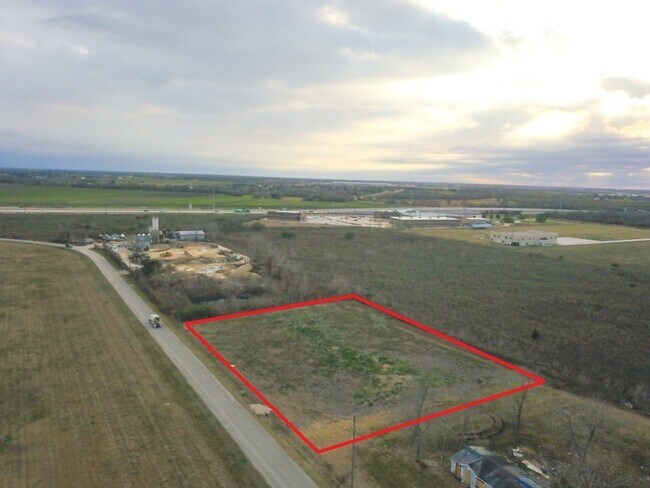

Property Detail
Walsh Rd
Houston-Pasadena-The Woodlands, TX
WALSH ROAD INDUSTRIAL PARK, ACRES 1, RESERVE S (NON-RESIDENTIAL) (93% IN SM106)
8916-00-000-0190-901
FORT BEND
Residentialacreage
Texas
B and X Area of moderate flood hazard, usually the area between the limits of the 100-year and 500-year floods.
0.99 AC
2024
Southwest Outlier
2025
Houston
675300
NEARBY LISTINGS FOR SALE OR LEASE
DEMOGRAPHICS near Walsh Rd
1 mile
3 mile
5 mile
2024 Total Population
2,005
22,425
53,989
2029 Population
2,388
26,908
65,143
Pop Growth 2024-2029
+ 19.10%
+ 19.99%
+ 20.66%
Average Age
35
36
36
2024 Total Households
583
7,377
17,891
HH Growth 2024-2029
+ 19.55%
+ 20.54%
+ 21.22%
Median Household Inc
$66,398
$53,459
$60,882
Avg Household Size
3.40
3.00
3.00
2024 Avg HH Vehicles
2.00
2.00
2.00
Median Home Value
$75,384
$169,144
$204,359
Median Year Built
1994
1988
1992
Nearby Places
Map Layers
Map Styles
 Street
 Aerial
Transit
 Traffic
 Biking
Places
Listings with unknown addresses are not visible on the map
- Restaurants
- Banks
- Shops
- Fitness
- Groceries
PUBLIC TRANSPORTATION
AIRPORT
William P Hobby
Drive
Walk
Distance
William P Hobby
58 min
42.8 mi
Freight Ports
Port of Houston
Drive
Walk
Distance
Port of Houston
60 min
43.4 mi
SALE & LEASE HISTORY
LISTING DATE
SALE/LEASE

May 11, 2021
For Sale
Nearby Properties
Address
Land Use
TOTAL SIZE
Lot Size
Zoning
Address
Land Use
TOTAL SIZE
Lot Size
Zoning
146.35 AC
ST
Address
Land Use
TOTAL SIZE
Lot Size
Zoning
44.35 AC
YOSN
Address
Land Use
TOTAL SIZE
Lot Size
Zoning
672,112 SF
81.77 AC
YHN
Address
Land Use
TOTAL SIZE
Lot Size
Zoning
98,691 SF
29.37 AC
Address
Land Use
TOTAL SIZE
Lot Size
Zoning
16.23 AC
Address
Land Use
TOTAL SIZE
Lot Size
Zoning
672 SF
230.34 AC
YT
Address
Land Use
TOTAL SIZE
Lot Size
Zoning
54,406 SF
13.13 AC
Address
Land Use
TOTAL SIZE
Lot Size
Zoning
54.25 AC
L
Address
Land Use
TOTAL SIZE
Lot Size
Zoning
37.08 AC
Address
Land Use
TOTAL SIZE
Lot Size
Zoning
1,216 SF
24.38 AC
YZS
Address
Land Use
TOTAL SIZE
Lot Size
Zoning
66,896 SF
18.60 AC
ZNY
Address
Land Use
TOTAL SIZE
Lot Size
Zoning
25.69 AC
Address
Land Use
TOTAL SIZE
Lot Size
Zoning
4,524 SF
13.68 AC
Address
Land Use
TOTAL SIZE
Lot Size
Zoning
37,951 SF
5.39 AC
L
Address
Land Use
TOTAL SIZE
Lot Size
Zoning
145,000 SF
17.36 AC
YSNM
Address
Land Use
TOTAL SIZE
Lot Size
Zoning
30.57 AC
Address
Land Use
TOTAL SIZE
Lot Size
Zoning
8.01 AC
Address
Land Use
TOTAL SIZE
Lot Size
Zoning
4.20 AC
YS
Address
Land Use
TOTAL SIZE
Lot Size
Zoning
21,218 SF
1.86 AC
Address
Land Use
TOTAL SIZE
Lot Size
Zoning
133,826 SF
11.60 AC
Address
Land Use
TOTAL SIZE
Lot Size
Zoning
45,695 SF
3.38 AC
XY
Address
Land Use
TOTAL SIZE
Lot Size
Zoning
7.89 AC
SZ
Address
Land Use
TOTAL SIZE
Lot Size
Zoning
11,800 SF
9.26 AC
S
Address
Land Use
TOTAL SIZE
Lot Size
Zoning
40.49 AC
OY
Address
Land Use
TOTAL SIZE
Lot Size
Zoning
175,001 SF
14.37 AC
SY
Address
Land Use
TOTAL SIZE
Lot Size
Zoning
82,127 SF
6.18 AC
L
Address
Land Use
TOTAL SIZE
Lot Size
Zoning
72,400 SF
10 AC
Address
Land Use
TOTAL SIZE
Lot Size
Zoning
62,521 SF
3.05 AC
XY
Address
Land Use
TOTAL SIZE
Lot Size
Zoning
85,000 SF
19.49 AC
SN
Address
Land Use
TOTAL SIZE
Lot Size
Zoning
1,064 SF
68.45 AC
OQY
The World's #1 Commercial Real Estate Marketplace
Connect with us
© 2026 CoStar Group
The information above has been obtained from sources believed reliable. While we do not doubt its accuracy we have not verified it and make no guarantee, warranty or representation about it. It is your responsibility to independently confirm its accuracy and completeness. Any projections, opinions, assumptions, or estimates used are for example only and do not represent the current or future performance of the property. The value of this transaction to you depends on tax and other factors which should be evaluated by your tax, financial, and legal advisors. You and your advisors should conduct a careful, independent investigation of the property to determine to your satisfaction the suitability of the property for your needs.