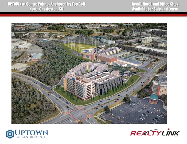
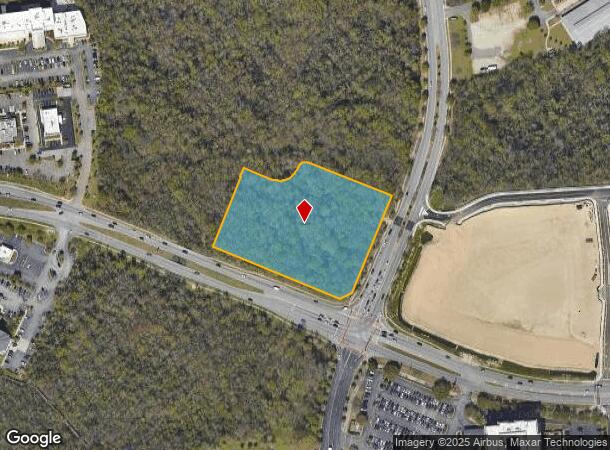
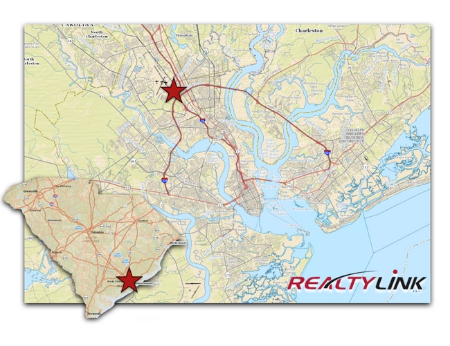
Property Record
5170 International Blvd, North Charleston, SC 29418
NEARBY LISTINGS FOR SALE OR LEASE
Property Detail
5170 International Blvd
Charleston-North Charleston, SC
City Of Charleston
400-00-00-228
Charleston
Sfr
South Carolina
X
North Charleston
45019C0482K
Charleston/N Charleston
520 SF
DEMOGRAPHICS near 5170 International Blvd
1 Mile
3 Mile
5 Mile
2024 Total Population
2,806
51,698
130,859
2029 Population
3,037
55,333
139,820
Pop Growth 2024-2029
+ 8.23%
+ 7.03%
+ 6.85%
Average Age
38
39
39
2024 Total Households
1,032
20,993
55,112
HH Growth 2024-2029
+ 8.33%
+ 6.85%
+ 6.59%
Median Household Inc
$41,508
$49,093
$56,033
Avg Household Size
2.40
2.30
2.30
2024 Avg HH Vehicles
2.00
2.00
2.00
Median Home Value
$141,860
$198,800
$255,593
Median Year Built
1986
1976
1982
Nearby Places
- Restaurants
- Banks
- Shops
- Fitness
- Groceries
PUBLIC TRANSPORTATION
COMMUTER RAIL
Charleston Amtrak Station (Palmetto - Amtrak, Silver Meteor - Amtrak)
DRIVE
WALK
Distance
Charleston Amtrak Station (Palmetto - Amtrak, Silver Meteor - Amtrak)
5 min
2.5 mi
AIRPORT
Charleston AFB/International
DRIVE
WALK
Distance
Charleston AFB/International
9 min
5.2 mi
Freight Ports
North Charleston Terminal
DRIVE
WALK
Distance
North Charleston Terminal
6 min
4.3 mi
SALE & LEASE HISTORY
LISTING DATE
SALE/LEASE

Oct 04, 2021
For Lease
Nearby Properties
Address
Land Use
TOTAL SIZE
Lot Size
Zoning
Address
Land Use
TOTAL SIZE
Lot Size
Zoning
1,717 SF
40.95 AC
Address
Land Use
TOTAL SIZE
Lot Size
Zoning
68,655 SF
9.48 AC
Address
Land Use
TOTAL SIZE
Lot Size
Zoning
36,587 SF
17.75 AC
Address
Land Use
TOTAL SIZE
Lot Size
Zoning
10,560 SF
7.50 AC
Address
Land Use
TOTAL SIZE
Lot Size
Zoning
4,740 SF
12.17 AC
Address
Land Use
TOTAL SIZE
Lot Size
Zoning
17,271 SF
3.65 AC
Address
Land Use
TOTAL SIZE
Lot Size
Zoning
112,860 SF
12 AC
Address
Land Use
TOTAL SIZE
Lot Size
Zoning
6,036 SF
8.79 AC
Address
Land Use
TOTAL SIZE
Lot Size
Zoning
77,990 SF
8.30 AC
Address
Land Use
TOTAL SIZE
Lot Size
Zoning
48,885 SF
5.02 AC
Address
Land Use
TOTAL SIZE
Lot Size
Zoning
19,992 SF
11.98 AC
Address
Land Use
TOTAL SIZE
Lot Size
Zoning
42,500 SF
3.62 AC
Address
Land Use
TOTAL SIZE
Lot Size
Zoning
1,303 SF
4.77 AC
Address
Land Use
TOTAL SIZE
Lot Size
Zoning
15,027 SF
3.62 AC
HANAHAN -
Address
Land Use
TOTAL SIZE
Lot Size
Zoning
3,192 SF
34.47 AC
Address
Land Use
TOTAL SIZE
Lot Size
Zoning
1,575 SF
28.28 AC
Address
Land Use
TOTAL SIZE
Lot Size
Zoning
30,064 SF
33.86 AC
Address
Land Use
TOTAL SIZE
Lot Size
Zoning
16,917 SF
2.40 AC
Address
Land Use
TOTAL SIZE
Lot Size
Zoning
50,356 SF
5.19 AC
Address
Land Use
TOTAL SIZE
Lot Size
Zoning
17,127 SF
2.52 AC
Address
Land Use
TOTAL SIZE
Lot Size
Zoning
25.97 AC
Address
Land Use
TOTAL SIZE
Lot Size
Zoning
23,900 SF
2.39 AC
HANAHAN -
Address
Land Use
TOTAL SIZE
Lot Size
Zoning
86,024 SF
9.69 AC
Address
Land Use
TOTAL SIZE
Lot Size
Zoning
2,438 SF
33.72 AC
Address
Land Use
TOTAL SIZE
Lot Size
Zoning
896 SF
6.09 AC
Address
Land Use
TOTAL SIZE
Lot Size
Zoning
14,250 SF
2.08 AC
Address
Land Use
TOTAL SIZE
Lot Size
Zoning
1,236 SF
1.88 AC
Address
Land Use
TOTAL SIZE
Lot Size
Zoning
Address
Land Use
TOTAL SIZE
Lot Size
Zoning
40,050 SF
2.33 AC
Address
Land Use
TOTAL SIZE
Lot Size
Zoning
7,935 SF
1.11 AC
The World's #1 Commercial Real Estate Marketplace
Connect with us
© 2025 CoStar Group
The information above has been obtained from sources believed reliable. While we do not doubt its accuracy we have not verified it and make no guarantee, warranty or representation about it. It is your responsibility to independently confirm its accuracy and completeness. Any projections, opinions, assumptions, or estimates used are for example only and do not represent the current or future performance of the property. The value of this transaction to you depends on tax and other factors which should be evaluated by your tax, financial, and legal advisors. You and your advisors should conduct a careful, independent investigation of the property to determine to your satisfaction the suitability of the property for your needs.