Property Record
Wauconda Rd, Mchenry, IL 60050
Save to a Folder
{{folder.Name}}
{{folder.ListingIds.length}} Properties
{{folder.ListingIds.length}} Property
Create a New Folder
This Property Is For Sale
Property Detail
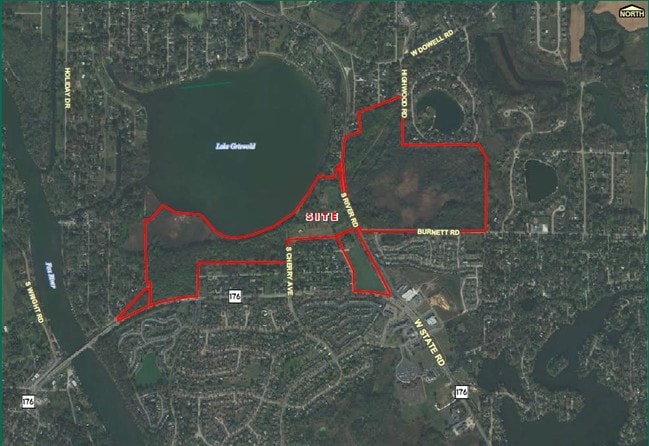
Wauconda Rd
Chicago-Naperville-Elgin, IL-IN
DOC 2010R0018287 PT SW1/4 LYING W OF RIVER RD & S OF WOOD LANE /EX HALES GRISWOLD LAKE SUB & EX HALES GRISWOLD LAKE 1ST ADDN & EX THAT PT ANNEXED TO VILL OF ISLAND LAKE PER DOC 2023R0031628/
15-19-226-001
MCHENRY
Vacantlandnec
Illinois
AE The base floodplain where base flood elevations are provided. AE Zones are now used on new format FIRMs instead of A1-A30 Zones.
29.07 AC
2024
Far Northwest
2024
Chicago
870811
NEARBY LISTINGS FOR SALE OR LEASE
DEMOGRAPHICS near Wauconda Rd
1 mile
3 mile
5 mile
2025 Total Population
5,552
18,101
75,087
2030 Population
5,612
18,242
76,139
Pop Growth 2025-2030
+ 1.08%
+ 0.78%
+ 1.40%
Average Age
42
42
41
2025 Total Households
2,224
6,973
28,273
HH Growth 2025-2030
+ 1.12%
+ 0.80%
+ 1.44%
Median Household Inc
$87,532
$97,579
$107,837
Avg Household Size
2.50
2.60
2.60
2025 Avg HH Vehicles
2.00
2.00
2.00
Median Home Value
$239,349
$282,840
$308,165
Median Year Built
1984
1985
1990
Nearby Places
Map Layers
Map Styles
 Street
 Aerial
Layers
 Traffic
 Biking
Places
Listings with unknown addresses are not visible on the map
- Restaurants
- Banks
- Shops
- Fitness
- Groceries
PUBLIC TRANSPORTATION
COMMUTER RAIL
Pingree Road Station (Union Pacific Northwest Line - Northeast Illinois Regional Commuter Railroad (Metra))
Drive
Walk
Distance
Pingree Road Station (Union Pacific Northwest Line - Northeast Illinois Regional Commuter Railroad (Metra))
14 min
6.5 mi
Mchenry Station (Union Pacific Northwest Line - Northeast Illinois Regional Commuter Railroad (Metra))
Drive
Walk
Distance
Mchenry Station (Union Pacific Northwest Line - Northeast Illinois Regional Commuter Railroad (Metra))
16 min
7.4 mi
AIRPORT
Chicago O'Hare International
Drive
Walk
Distance
Chicago O'Hare International
50 min
35.1 mi
Freight Ports
Port Milwaukee
Drive
Walk
Distance
Port Milwaukee
88 min
66.4 mi
Nearby Properties
Address
Land Use
TOTAL SIZE
Lot Size
Zoning
Address
Land Use
TOTAL SIZE
Lot Size
Zoning
393,554 SF
83.76 AC
Address
Land Use
TOTAL SIZE
Lot Size
Zoning
212,880 SF
20.06 AC
Address
Land Use
TOTAL SIZE
Lot Size
Zoning
114,186 SF
17.14 AC
Address
Land Use
TOTAL SIZE
Lot Size
Zoning
60,202 SF
5 AC
Address
Land Use
TOTAL SIZE
Lot Size
Zoning
18,873 SF
159.95 AC
Address
Land Use
TOTAL SIZE
Lot Size
Zoning
163,800 SF
5 AC
Address
Land Use
TOTAL SIZE
Lot Size
Zoning
87,600 SF
17.05 AC
Address
Land Use
TOTAL SIZE
Lot Size
Zoning
25,900 SF
0.64 AC
Address
Land Use
TOTAL SIZE
Lot Size
Zoning
3,825 SF
2.99 AC
Address
Land Use
TOTAL SIZE
Lot Size
Zoning
150,600 SF
3 AC
Address
Land Use
TOTAL SIZE
Lot Size
Zoning
177,840 SF
2.53 AC
Address
Land Use
TOTAL SIZE
Lot Size
Zoning
21,730 SF
3.22 AC
Address
Land Use
TOTAL SIZE
Lot Size
Zoning
23,061 SF
1.43 AC
Address
Land Use
TOTAL SIZE
Lot Size
Zoning
7,870 SF
35 AC
Address
Land Use
TOTAL SIZE
Lot Size
Zoning
18,200 SF
3.45 AC
Address
Land Use
TOTAL SIZE
Lot Size
Zoning
10,857 SF
1.68 AC
Address
Land Use
TOTAL SIZE
Lot Size
Zoning
14,736 SF
2.31 AC
Address
Land Use
TOTAL SIZE
Lot Size
Zoning
16,243 SF
1.92 AC
Address
Land Use
TOTAL SIZE
Lot Size
Zoning
12,250 SF
5 AC
Address
Land Use
TOTAL SIZE
Lot Size
Zoning
10,000 SF
6.73 AC
Address
Land Use
TOTAL SIZE
Lot Size
Zoning
5,125 SF
5.65 AC
Address
Land Use
TOTAL SIZE
Lot Size
Zoning
54,300 SF
2.91 AC
Address
Land Use
TOTAL SIZE
Lot Size
Zoning
9,600 SF
5.99 AC
Address
Land Use
TOTAL SIZE
Lot Size
Zoning
7,188 SF
2.29 AC
Address
Land Use
TOTAL SIZE
Lot Size
Zoning
9,326 SF
1.91 AC
Address
Land Use
TOTAL SIZE
Lot Size
Zoning
43,599 SF
10.21 AC
Address
Land Use
TOTAL SIZE
Lot Size
Zoning
39,145 SF
2.24 AC
Address
Land Use
TOTAL SIZE
Lot Size
Zoning
4,305 SF
1 AC
Address
Land Use
TOTAL SIZE
Lot Size
Zoning
25,080 SF
5 AC
Address
Land Use
TOTAL SIZE
Lot Size
Zoning
6,647 SF
51.44 AC
The World's #1 Commercial Real Estate Marketplace
Connect with us
© 2026 CoStar Group
The information above has been obtained from sources believed reliable. While we do not doubt its accuracy we have not verified it and make no guarantee, warranty or representation about it. It is your responsibility to independently confirm its accuracy and completeness. Any projections, opinions, assumptions, or estimates used are for example only and do not represent the current or future performance of the property. The value of this transaction to you depends on tax and other factors which should be evaluated by your tax, financial, and legal advisors. You and your advisors should conduct a careful, independent investigation of the property to determine to your satisfaction the suitability of the property for your needs.