Property Record
Waupun Rd, Oshkosh, WI 54901

This Property Is For Sale
Property Detail
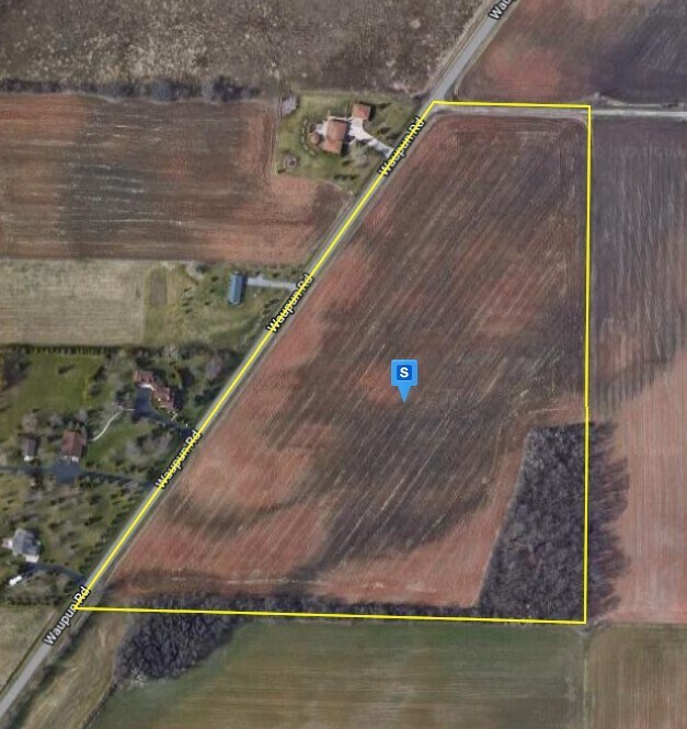
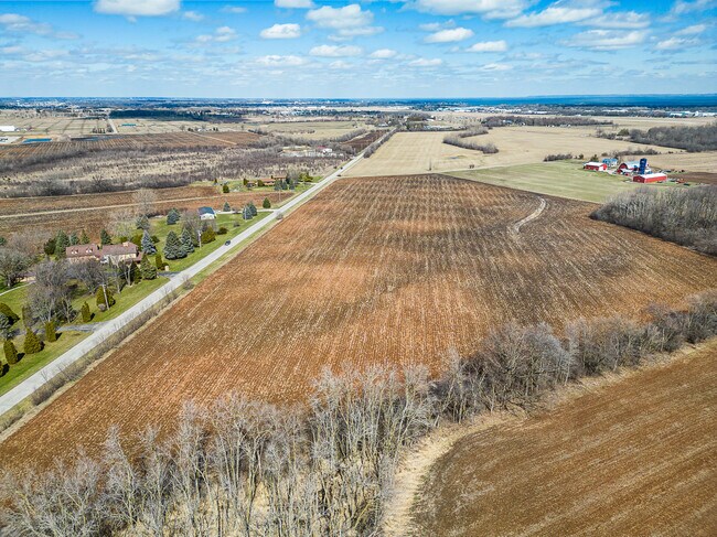
Waupun Rd
012-0183
NE SW EXC N 200 FT LYG W OF HWY & EXC PT IN D707018 D744053 D747276 D750384 26.03 A.
Timberlandforesttreesagricultural
WINNEBAGO
A2
Wisconsin
B and X Area of moderate flood hazard, usually the area between the limits of the 100-year and 500-year floods.
26.03 AC
2024
Appleton/Oshkosh
2024
Other Market Areas
000400
Oshkosh-Neenah, WI
NEARBY LISTINGS FOR SALE OR LEASE
DEMOGRAPHICS near Waupun Rd
1 mile
3 mile
5 mile
2025 Total Population
77
6,870
43,292
2030 Population
80
7,017
44,032
Pop Growth 2025-2030
+ 3.90%
+ 2.14%
+ 1.71%
Average Age
45
45
40
2025 Total Households
36
3,200
19,531
HH Growth 2025-2030
+ 2.78%
+ 2.06%
+ 1.80%
Median Household Inc
$82,500
$72,622
$63,781
Avg Household Size
2.00
2.10
2.10
2025 Avg HH Vehicles
2.00
2.00
2.00
Median Home Value
$287,499
$247,360
$191,477
Median Year Built
1996
1984
1975
Nearby Places
Map Layers
Map Styles
 Street
 Aerial
Transit
 Traffic
 Biking
Places
Listings with unknown addresses are not visible on the map
- Restaurants
- Banks
- Shops
- Fitness
- Groceries
PUBLIC TRANSPORTATION
AIRPORT
Appleton International
Drive
Walk
Distance
Appleton International
34 min
26.3 mi
Freight Ports
Port Milwaukee
Drive
Walk
Distance
Port Milwaukee
99 min
83.6 mi
Nearby Properties
Address
Land Use
TOTAL SIZE
Lot Size
Zoning
Address
Land Use
TOTAL SIZE
Lot Size
Zoning
931,304 SF
107 AC
M3
Address
Land Use
TOTAL SIZE
Lot Size
Zoning
15.37 AC
SMU-PD
Address
Land Use
TOTAL SIZE
Lot Size
Zoning
570,585 SF
81.26 AC
M2
Address
Land Use
TOTAL SIZE
Lot Size
Zoning
18.38 AC
UIPD
Address
Land Use
TOTAL SIZE
Lot Size
Zoning
41.70 AC
HI
Address
Land Use
TOTAL SIZE
Lot Size
Zoning
110,200 SF
14.77 AC
MR-12-PD
Address
Land Use
TOTAL SIZE
Lot Size
Zoning
238,238 SF
22.60 AC
M3
Address
Land Use
TOTAL SIZE
Lot Size
Zoning
19,488 SF
16.43 AC
C-2
Address
Land Use
TOTAL SIZE
Lot Size
Zoning
271,088 SF
36.80 AC
M3
Address
Land Use
TOTAL SIZE
Lot Size
Zoning
341,904 SF
40.71 AC
HI
Address
Land Use
TOTAL SIZE
Lot Size
Zoning
107,778 SF
8.57 AC
SMUPD
Address
Land Use
TOTAL SIZE
Lot Size
Zoning
117,892 SF
7.36 AC
MR-20
Address
Land Use
TOTAL SIZE
Lot Size
Zoning
92,958 SF
1.02 AC
C2
Address
Land Use
TOTAL SIZE
Lot Size
Zoning
114,338 SF
10.20 AC
C2
Address
Land Use
TOTAL SIZE
Lot Size
Zoning
58,465 SF
43.67 AC
M3
Address
Land Use
TOTAL SIZE
Lot Size
Zoning
32,430 SF
7.44 AC
M1
Address
Land Use
TOTAL SIZE
Lot Size
Zoning
28,512 SF
6.20 AC
M1
Address
Land Use
TOTAL SIZE
Lot Size
Zoning
91,288 SF
7.29 AC
MR-12
Address
Land Use
TOTAL SIZE
Lot Size
Zoning
42,092 SF
3.21 AC
C2
Address
Land Use
TOTAL SIZE
Lot Size
Zoning
126,814 SF
22.60 AC
HI
Address
Land Use
TOTAL SIZE
Lot Size
Zoning
210,000 SF
10.02 AC
M3
Address
Land Use
TOTAL SIZE
Lot Size
Zoning
62,880 SF
5.78 AC
M3
Address
Land Use
TOTAL SIZE
Lot Size
Zoning
66,456 SF
5.91 AC
MR-12-PD
Address
Land Use
TOTAL SIZE
Lot Size
Zoning
38,858 SF
8.15 AC
M1
Address
Land Use
TOTAL SIZE
Lot Size
Zoning
115,624 SF
14.41 AC
M3
Address
Land Use
TOTAL SIZE
Lot Size
Zoning
13.67 AC
Address
Land Use
TOTAL SIZE
Lot Size
Zoning
47,932 SF
4.95 AC
C2
Address
Land Use
TOTAL SIZE
Lot Size
Zoning
47,856 SF
5.26 AC
SMU-PD
Address
Land Use
TOTAL SIZE
Lot Size
Zoning
13.75 AC
Address
Land Use
TOTAL SIZE
Lot Size
Zoning
16.34 AC
The World's #1 Commercial Real Estate Marketplace
Connect with us
© 2026 CoStar Group
The information above has been obtained from sources believed reliable. While we do not doubt its accuracy we have not verified it and make no guarantee, warranty or representation about it. It is your responsibility to independently confirm its accuracy and completeness. Any projections, opinions, assumptions, or estimates used are for example only and do not represent the current or future performance of the property. The value of this transaction to you depends on tax and other factors which should be evaluated by your tax, financial, and legal advisors. You and your advisors should conduct a careful, independent investigation of the property to determine to your satisfaction the suitability of the property for your needs.