Property Record
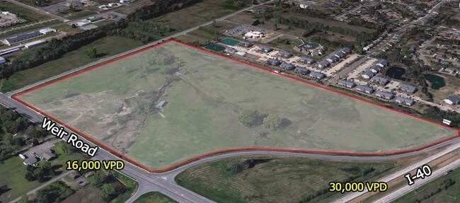
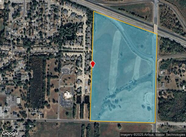
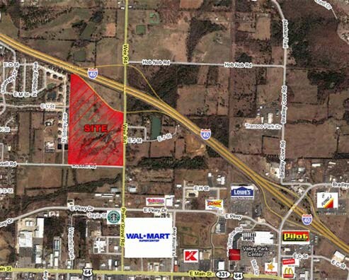
Weir Rd, Russellville, AR 72802
NEARBY LISTINGS FOR SALE OR LEASE
Property Detail
Weir Rd
Russellville, AR
Rsvl By Sections
863-30001-002C
PT W/2 NE CITY OF RUSSELLVILLE
Commercialnec
Pope
AE
Arkansas
05115C0390E
51.68 AC
2024
Fort Smith/Russellville I-40
2025
Other Market Areas
951201
DEMOGRAPHICS near Weir Rd
1 Mile
3 Mile
5 Mile
2024 Total Population
3,670
25,392
37,934
2029 Population
3,745
25,942
38,788
Pop Growth 2024-2029
+ 2.04%
+ 2.17%
+ 2.25%
Average Age
34
36
37
2024 Total Households
1,536
9,833
14,446
HH Growth 2024-2029
+ 2.08%
+ 2.26%
+ 2.34%
Median Household Inc
$34,887
$40,925
$45,649
Avg Household Size
2.20
2.40
2.40
2024 Avg HH Vehicles
2.00
2.00
2.00
Median Home Value
$89,763
$148,671
$165,269
Median Year Built
1979
1982
1984
Nearby Places
Map Layers
Map Styles
 Street
 Aerial
- Restaurants
- Banks
- Shops
- Fitness
- Groceries
SALE & LEASE HISTORY
LISTING DATE
SALE/LEASE

Sep 27, 2017
For Sale
Sep 26, 2017
For Sale
Jun 23, 2017
For Sale
Nearby Properties
Address
Land Use
TOTAL SIZE
Lot Size
Zoning
Address
Land Use
TOTAL SIZE
Lot Size
Zoning
95,305 SF
17.27 AC
Address
Land Use
TOTAL SIZE
Lot Size
Zoning
89,217 SF
5.87 AC
Address
Land Use
TOTAL SIZE
Lot Size
Zoning
807,059 SF
53.70 AC
Address
Land Use
TOTAL SIZE
Lot Size
Zoning
189,756 SF
18.30 AC
Address
Land Use
TOTAL SIZE
Lot Size
Zoning
61,652 SF
20 AC
Address
Land Use
TOTAL SIZE
Lot Size
Zoning
221,457 SF
22.28 AC
Address
Land Use
TOTAL SIZE
Lot Size
Zoning
277,687 SF
28.83 AC
Address
Land Use
TOTAL SIZE
Lot Size
Zoning
68,660 SF
17.63 AC
Address
Land Use
TOTAL SIZE
Lot Size
Zoning
4,550 SF
7.26 AC
Address
Land Use
TOTAL SIZE
Lot Size
Zoning
194,164 SF
55.75 AC
Address
Land Use
TOTAL SIZE
Lot Size
Zoning
2,001 SF
7.80 AC
Address
Land Use
TOTAL SIZE
Lot Size
Zoning
109,751 SF
15.40 AC
Address
Land Use
TOTAL SIZE
Lot Size
Zoning
18,448 SF
1.66 AC
Address
Land Use
TOTAL SIZE
Lot Size
Zoning
113,308 SF
18.02 AC
Address
Land Use
TOTAL SIZE
Lot Size
Zoning
69,646 SF
121.78 AC
Address
Land Use
TOTAL SIZE
Lot Size
Zoning
68,100 SF
1.55 AC
Address
Land Use
TOTAL SIZE
Lot Size
Zoning
12,078 SF
22.32 AC
Address
Land Use
TOTAL SIZE
Lot Size
Zoning
327,436 SF
29 AC
Address
Land Use
TOTAL SIZE
Lot Size
Zoning
65,141 SF
2.35 AC
Address
Land Use
TOTAL SIZE
Lot Size
Zoning
81,844 SF
7.30 AC
Address
Land Use
TOTAL SIZE
Lot Size
Zoning
39,992 SF
8.91 AC
Address
Land Use
TOTAL SIZE
Lot Size
Zoning
133,229 SF
40 AC
Address
Land Use
TOTAL SIZE
Lot Size
Zoning
226,225 SF
27.89 AC
Address
Land Use
TOTAL SIZE
Lot Size
Zoning
42,183 SF
6.92 AC
Address
Land Use
TOTAL SIZE
Lot Size
Zoning
195,016 SF
12.91 AC
Address
Land Use
TOTAL SIZE
Lot Size
Zoning
245,532 SF
25.93 AC
Address
Land Use
TOTAL SIZE
Lot Size
Zoning
64,974 SF
7.33 AC
Address
Land Use
TOTAL SIZE
Lot Size
Zoning
124,946 SF
9.10 AC
Address
Land Use
TOTAL SIZE
Lot Size
Zoning
12,315 SF
7.50 AC
Address
Land Use
TOTAL SIZE
Lot Size
Zoning
42,100 SF
4.70 AC
The World's #1 Commercial Real Estate Marketplace
Connect with us
© 2026 CoStar Group
The information above has been obtained from sources believed reliable. While we do not doubt its accuracy we have not verified it and make no guarantee, warranty or representation about it. It is your responsibility to independently confirm its accuracy and completeness. Any projections, opinions, assumptions, or estimates used are for example only and do not represent the current or future performance of the property. The value of this transaction to you depends on tax and other factors which should be evaluated by your tax, financial, and legal advisors. You and your advisors should conduct a careful, independent investigation of the property to determine to your satisfaction the suitability of the property for your needs.