Property Record
30081 Wells Rd, Wesley Chapel, FL 33545

NEARBY LISTINGS FOR SALE OR LEASE
Property Detail
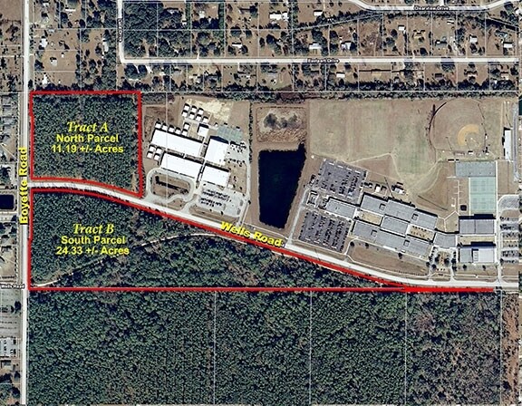
30081 Wells Rd
04-26-20-0000-00100-0000
Acreage
Religious
COM AT NW COR SEC 4 TH N89DEG 49 27E 28 FT FOR POB TH N89DEG 57 33E 755.10 FT TH S00DEG 0227E 572.54 FT TH S40DEG 5127E 14.57 FT TH S00DEG 0227E 151.56 FT TH N72DEG 3624W 178.85 FT TH 468.60 FT ALG ARC OF CURVE LEFT RADIUS 1540.00 FT CHD BRG & DIST N
AE
Pasco
12101C0264F
Florida
2024
11.18 AC
2026
Pasco County
032103
Tampa/St Petersburg
13,050 SF
Tampa-St. Petersburg-Clearwater, FL
DEMOGRAPHICS near 30081 Wells Rd
1 Mile
3 Mile
5 Mile
2024 Total Population
5,678
35,800
80,901
2029 Population
6,888
44,021
98,945
Pop Growth 2024-2029
+ 21.31%
+ 22.96%
+ 22.30%
Average Age
37
37
39
2024 Total Households
1,842
11,847
28,144
HH Growth 2024-2029
+ 21.34%
+ 22.90%
+ 22.20%
Median Household Inc
$88,304
$99,598
$99,298
Avg Household Size
3.00
2.90
2.80
2024 Avg HH Vehicles
2.00
2.00
2.00
Median Home Value
$247,031
$305,736
$308,196
Median Year Built
2004
2007
2007
Nearby Places
Map Layers
Map Styles
 Street
 Aerial
- Restaurants
- Banks
- Shops
- Fitness
- Groceries
PUBLIC TRANSPORTATION
AIRPORT
Tampa International
DRIVE
WALK
Distance
Tampa International
46 min
32.8 mi
Freight Ports
Port of Tampa Bay
DRIVE
WALK
Distance
Port of Tampa Bay
42 min
28.5 mi
SALE & LEASE HISTORY
LISTING DATE
SALE/LEASE

Sep 24, 2016
For Sale
Nearby Properties
Address
Land Use
TOTAL SIZE
Lot Size
Zoning
Address
Land Use
TOTAL SIZE
Lot Size
Zoning
435,775 SF
138.45 AC
AR
Address
Land Use
TOTAL SIZE
Lot Size
Zoning
343,155 SF
23.92 AC
MPUD
Address
Land Use
TOTAL SIZE
Lot Size
Zoning
398,092 SF
22.48 AC
MPUD
Address
Land Use
TOTAL SIZE
Lot Size
Zoning
319,575 SF
19.80 AC
MPUD
Address
Land Use
TOTAL SIZE
Lot Size
Zoning
301,145 SF
17.99 AC
MPUD
Address
Land Use
TOTAL SIZE
Lot Size
Zoning
275,549 SF
16.24 AC
C2
Address
Land Use
TOTAL SIZE
Lot Size
Zoning
418,644 SF
105.51 AC
AR
Address
Land Use
TOTAL SIZE
Lot Size
Zoning
287,834 SF
14.40 AC
MPUD
Address
Land Use
TOTAL SIZE
Lot Size
Zoning
241,371 SF
11.48 AC
MPUD
Address
Land Use
TOTAL SIZE
Lot Size
Zoning
244,355 SF
70.12 AC
MPUD
Address
Land Use
TOTAL SIZE
Lot Size
Zoning
146,401 SF
17.78 AC
MPUD
Address
Land Use
TOTAL SIZE
Lot Size
Zoning
142,552 SF
5.69 AC
MPUD
Address
Land Use
TOTAL SIZE
Lot Size
Zoning
115,596 SF
3.83 AC
C2
Address
Land Use
TOTAL SIZE
Lot Size
Zoning
28,631 SF
8.84 AC
MPUD
Address
Land Use
TOTAL SIZE
Lot Size
Zoning
109,440 SF
3.28 AC
C2
Address
Land Use
TOTAL SIZE
Lot Size
Zoning
189,610 SF
13.68 AC
MPUD
Address
Land Use
TOTAL SIZE
Lot Size
Zoning
38,392 SF
9.54 AC
MPUD
Address
Land Use
TOTAL SIZE
Lot Size
Zoning
210,354 SF
29.03 AC
C2
Address
Land Use
TOTAL SIZE
Lot Size
Zoning
93,933 SF
3.63 AC
C2
Address
Land Use
TOTAL SIZE
Lot Size
Zoning
118,441 SF
14.20 AC
C2
Address
Land Use
TOTAL SIZE
Lot Size
Zoning
80,584 SF
22.43 AC
MPUD
Address
Land Use
TOTAL SIZE
Lot Size
Zoning
235,286 SF
15.11 AC
MF2
Address
Land Use
TOTAL SIZE
Lot Size
Zoning
91,050 SF
4.18 AC
C2
Address
Land Use
TOTAL SIZE
Lot Size
Zoning
99,666 SF
8.68 AC
MPUD
Address
Land Use
TOTAL SIZE
Lot Size
Zoning
46,583 SF
10.06 AC
C2
Address
Land Use
TOTAL SIZE
Lot Size
Zoning
48,241 SF
7.67 AC
MPUD
Address
Land Use
TOTAL SIZE
Lot Size
Zoning
69,712 SF
10.27 AC
C2
Address
Land Use
TOTAL SIZE
Lot Size
Zoning
17,906 SF
12 AC
MPUD
Address
Land Use
TOTAL SIZE
Lot Size
Zoning
55,697 SF
7.78 AC
MPUD
Address
Land Use
TOTAL SIZE
Lot Size
Zoning
31,857 SF
3.46 AC
MPUD
The World's #1 Commercial Real Estate Marketplace
Connect with us
© 2025 CoStar Group
The information above has been obtained from sources believed reliable. While we do not doubt its accuracy we have not verified it and make no guarantee, warranty or representation about it. It is your responsibility to independently confirm its accuracy and completeness. Any projections, opinions, assumptions, or estimates used are for example only and do not represent the current or future performance of the property. The value of this transaction to you depends on tax and other factors which should be evaluated by your tax, financial, and legal advisors. You and your advisors should conduct a careful, independent investigation of the property to determine to your satisfaction the suitability of the property for your needs.