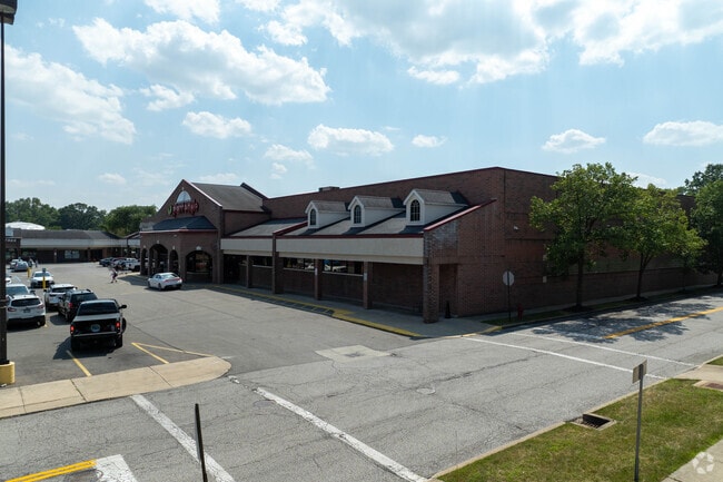
Property Record
West Bridge St, Berea, OH 44017

NEARBY LISTINGS FOR SALE OR LEASE
Property Detail
West Bridge St
Cleveland-Elyria, OH
Sheldon Add
364-08-006
17 SHELDON ADDITION S/L 10 TO 13 ALL & VAC ALLEY 36408006 TO36408009
Stripcommercialcenter
Cuyahoga
X
Ohio
39035C0276E
17
2024
1.16 AC
2024
Southwest
134204
Cleveland
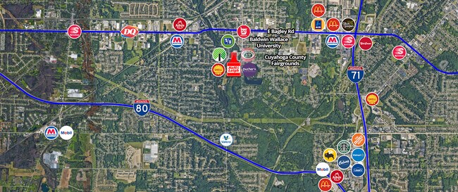
DEMOGRAPHICS near West Bridge St
1 Mile
3 Mile
5 Mile
2024 Total Population
10,130
50,289
146,199
2029 Population
9,818
49,028
142,428
Pop Growth 2024-2029
(3.08%)
(2.51%)
(2.58%)
Average Age
41
43
43
2024 Total Households
4,190
21,552
61,989
HH Growth 2024-2029
(3.20%)
(2.78%)
(2.80%)
Median Household Inc
$55,038
$72,253
$71,997
Avg Household Size
2.10
2.20
2.30
2024 Avg HH Vehicles
2.00
2.00
2.00
Median Home Value
$166,757
$186,360
$184,482
Median Year Built
1955
1968
1967
Nearby Places
Map Layers
Map Styles
 Street
 Aerial
- Restaurants
- Banks
- Shops
- Fitness
- Groceries
PUBLIC TRANSPORTATION
AIRPORT
Cleveland-Hopkins International
DRIVE
WALK
Distance
Cleveland-Hopkins International
13 min
6.0 mi
Freight Ports
Port of Toledo
DRIVE
WALK
Distance
Port of Toledo
122 min
102.6 mi
SALE & LEASE HISTORY
LISTING DATE
SALE/LEASE

Sep 25, 2016
For Lease
Aug 27, 2024
For Sale
Nearby Properties
Address
Land Use
TOTAL SIZE
Lot Size
Zoning
Address
Land Use
TOTAL SIZE
Lot Size
Zoning
748.88 AC
GI
Address
Land Use
TOTAL SIZE
Lot Size
Zoning
1,490,538 SF
19.29 AC
PF
Address
Land Use
TOTAL SIZE
Lot Size
Zoning
754.68 AC
GI
Address
Land Use
TOTAL SIZE
Lot Size
Zoning
526.33 AC
GI
Address
Land Use
TOTAL SIZE
Lot Size
Zoning
237,144 SF
2.12 AC
PG
Address
Land Use
TOTAL SIZE
Lot Size
Zoning
1,514 SF
23.65 AC
RSF-B
Address
Land Use
TOTAL SIZE
Lot Size
Zoning
208.22 AC
U5-A
Address
Land Use
TOTAL SIZE
Lot Size
Zoning
289,215 SF
20.56 AC
RSF-B
Address
Land Use
TOTAL SIZE
Lot Size
Zoning
768,485 SF
14.53 AC
R1-A
Address
Land Use
TOTAL SIZE
Lot Size
Zoning
244,717 SF
23.97 AC
RMF-1
Address
Land Use
TOTAL SIZE
Lot Size
Zoning
299,114 SF
23.65 AC
RSF-B
Address
Land Use
TOTAL SIZE
Lot Size
Zoning
126,000 SF
3.02 AC
PG
Address
Land Use
TOTAL SIZE
Lot Size
Zoning
309,231 SF
34.28 AC
Address
Land Use
TOTAL SIZE
Lot Size
Zoning
1,391,445 SF
136.05 AC
GI
Address
Land Use
TOTAL SIZE
Lot Size
Zoning
3.53 AC
SI
Address
Land Use
TOTAL SIZE
Lot Size
Zoning
364,000 SF
33.27 AC
U5-A
Address
Land Use
TOTAL SIZE
Lot Size
Zoning
300,120 SF
20.18 AC
GI
Address
Land Use
TOTAL SIZE
Lot Size
Zoning
263,867 SF
59.28 AC
PF
Address
Land Use
TOTAL SIZE
Lot Size
Zoning
426.60 AC
PF
Address
Land Use
TOTAL SIZE
Lot Size
Zoning
166,104 SF
4.70 AC
CC
Address
Land Use
TOTAL SIZE
Lot Size
Zoning
334,360 SF
8.22 AC
MF-HD
Address
Land Use
TOTAL SIZE
Lot Size
Zoning
263,926 SF
95.55 AC
GI
Address
Land Use
TOTAL SIZE
Lot Size
Zoning
78,000 SF
5.78 AC
OB
Address
Land Use
TOTAL SIZE
Lot Size
Zoning
275,274 SF
16.91 AC
RMF-1
Address
Land Use
TOTAL SIZE
Lot Size
Zoning
110,648 SF
10.79 AC
SR/LC
Address
Land Use
TOTAL SIZE
Lot Size
Zoning
112,629 SF
9.62 AC
RSF-B
Address
Land Use
TOTAL SIZE
Lot Size
Zoning
113,100 SF
7.80 AC
GB
Address
Land Use
TOTAL SIZE
Lot Size
Zoning
59,296 SF
7.08 AC
CC
Address
Land Use
TOTAL SIZE
Lot Size
Zoning
68,600 SF
58.22 AC
U6
Address
Land Use
TOTAL SIZE
Lot Size
Zoning
111,819 SF
12.78 AC
PF
The World's #1 Commercial Real Estate Marketplace
Connect with us
© 2026 CoStar Group
The information above has been obtained from sources believed reliable. While we do not doubt its accuracy we have not verified it and make no guarantee, warranty or representation about it. It is your responsibility to independently confirm its accuracy and completeness. Any projections, opinions, assumptions, or estimates used are for example only and do not represent the current or future performance of the property. The value of this transaction to you depends on tax and other factors which should be evaluated by your tax, financial, and legal advisors. You and your advisors should conduct a careful, independent investigation of the property to determine to your satisfaction the suitability of the property for your needs.