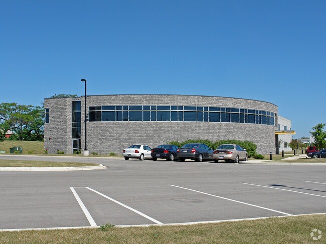
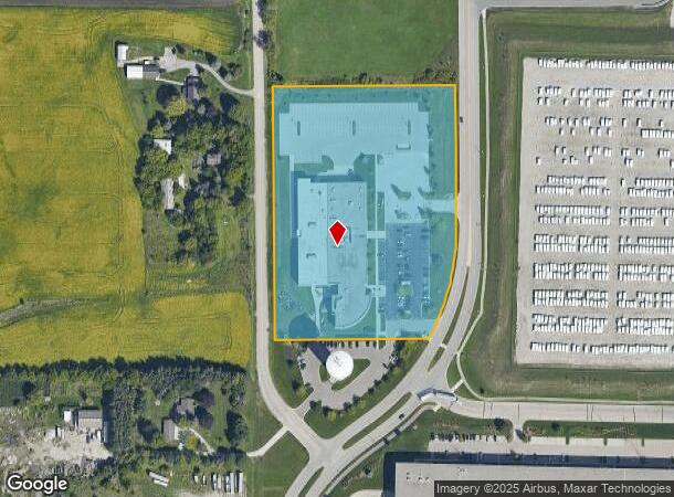
Property Record
West Rd, Sturtevant, WI 53177

NEARBY LISTINGS FOR SALE OR LEASE
Property Detail
West Rd
Racine-Mount Pleasant, WI
PT NW1/4 CSM #2384 V7P378 LOT 1 & PT LOT 1 CSM #2404 V7 P451 DAF COM NW COR S790 E33 S394 TO POB E477 S287 W477 N287 TO POB F
181-032221004020
Racine
Taxexempt
Wisconsin
AE
1
55101C0208E
7.04 AC
2024
Racine East
2024
Milwaukee/Madison
001703
DEMOGRAPHICS near West Rd
1 Mile
3 Mile
5 Mile
2024 Total Population
2,331
14,465
61,382
2029 Population
2,282
14,390
60,872
Pop Growth 2024-2029
(2.10%)
(0.52%)
(0.83%)
Average Age
42
42
42
2024 Total Households
401
5,481
24,986
HH Growth 2024-2029
(0.50%)
(0.15%)
(0.84%)
Median Household Inc
$54,947
$77,885
$71,489
Avg Household Size
2.30
2.30
2.30
2024 Avg HH Vehicles
2.00
2.00
2.00
Median Home Value
$160,050
$230,055
$218,984
Median Year Built
1971
1983
1973
Nearby Places
Map Layers
Map Styles
 Street
 Aerial
- Restaurants
- Banks
- Shops
- Fitness
- Groceries
PUBLIC TRANSPORTATION
COMMUTER RAIL
Sturtevant Amtrak Station (Hiawatha Service - Amtrak)
DRIVE
WALK
Distance
Sturtevant Amtrak Station (Hiawatha Service - Amtrak)
2 min
19 min
1.0 mi
AIRPORT
General Mitchell International
DRIVE
WALK
Distance
General Mitchell International
27 min
20.2 mi
Freight Ports
Port Milwaukee
DRIVE
WALK
Distance
Port Milwaukee
32 min
24.1 mi
Nearby Properties
Address
Land Use
TOTAL SIZE
Lot Size
Zoning
Address
Land Use
TOTAL SIZE
Lot Size
Zoning
861.42 AC
Address
Land Use
TOTAL SIZE
Lot Size
Zoning
318.64 AC
Address
Land Use
TOTAL SIZE
Lot Size
Zoning
Address
Land Use
TOTAL SIZE
Lot Size
Zoning
241.29 AC
Address
Land Use
TOTAL SIZE
Lot Size
Zoning
241.29 AC
Address
Land Use
TOTAL SIZE
Lot Size
Zoning
Address
Land Use
TOTAL SIZE
Lot Size
Zoning
9.40 AC
B-3
Address
Land Use
TOTAL SIZE
Lot Size
Zoning
23.10 AC
Address
Land Use
TOTAL SIZE
Lot Size
Zoning
37.55 AC
Address
Land Use
TOTAL SIZE
Lot Size
Zoning
47.01 AC
M-1
Address
Land Use
TOTAL SIZE
Lot Size
Zoning
32.55 AC
Address
Land Use
TOTAL SIZE
Lot Size
Zoning
57.80 AC
M1
Address
Land Use
TOTAL SIZE
Lot Size
Zoning
26.79 AC
Address
Land Use
TOTAL SIZE
Lot Size
Zoning
Address
Land Use
TOTAL SIZE
Lot Size
Zoning
Address
Land Use
TOTAL SIZE
Lot Size
Zoning
23.21 AC
Address
Land Use
TOTAL SIZE
Lot Size
Zoning
140.07 AC
Address
Land Use
TOTAL SIZE
Lot Size
Zoning
9.31 AC
Address
Land Use
TOTAL SIZE
Lot Size
Zoning
Address
Land Use
TOTAL SIZE
Lot Size
Zoning
30.45 AC
002
Address
Land Use
TOTAL SIZE
Lot Size
Zoning
13.04 AC
Address
Land Use
TOTAL SIZE
Lot Size
Zoning
18.33 AC
Address
Land Use
TOTAL SIZE
Lot Size
Zoning
10.72 AC
Address
Land Use
TOTAL SIZE
Lot Size
Zoning
20.61 AC
Address
Land Use
TOTAL SIZE
Lot Size
Zoning
19.29 AC
002
Address
Land Use
TOTAL SIZE
Lot Size
Zoning
5.74 AC
Address
Land Use
TOTAL SIZE
Lot Size
Zoning
Address
Land Use
TOTAL SIZE
Lot Size
Zoning
Address
Land Use
TOTAL SIZE
Lot Size
Zoning
22.98 AC
M-1
Address
Land Use
TOTAL SIZE
Lot Size
Zoning
31.50 AC
The World's #1 Commercial Real Estate Marketplace
Connect with us
© 2026 CoStar Group
The information above has been obtained from sources believed reliable. While we do not doubt its accuracy we have not verified it and make no guarantee, warranty or representation about it. It is your responsibility to independently confirm its accuracy and completeness. Any projections, opinions, assumptions, or estimates used are for example only and do not represent the current or future performance of the property. The value of this transaction to you depends on tax and other factors which should be evaluated by your tax, financial, and legal advisors. You and your advisors should conduct a careful, independent investigation of the property to determine to your satisfaction the suitability of the property for your needs.