Property Record
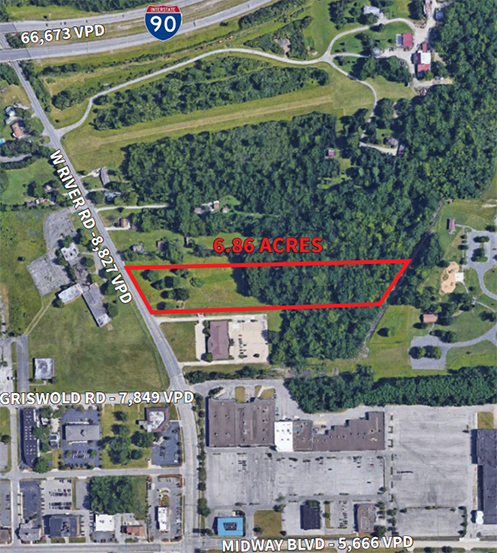
West River Rd, Elyria, OH 44035

Property Detail
West River Rd
Cleveland-Elyria, OH
NAME CORR 10/07/05
06-23-021-000-027
LORAIN
Commercialacreage
Ohio
A Areas with a 1% annual chance of flooding and a 26% chance of flooding over the life of a 30-year mortgage.
6.86 AC
2024
Lorain County
2024
Cleveland
070600
NEARBY LISTINGS FOR SALE OR LEASE
DEMOGRAPHICS near West River Rd
1 mile
3 mile
5 mile
2025 Total Population
2,861
52,338
129,740
2030 Population
2,949
53,427
132,912
Pop Growth 2025-2030
+ 3.08%
+ 2.08%
+ 2.44%
Average Age
44
42
41
2025 Total Households
1,504
22,610
53,122
HH Growth 2025-2030
+ 3.06%
+ 2.15%
+ 2.50%
Median Household Inc
$48,223
$57,856
$65,452
Avg Household Size
1.90
2.20
2.40
2025 Avg HH Vehicles
1.00
2.00
2.00
Median Home Value
$161,627
$155,300
$184,109
Median Year Built
1973
1961
1968
Nearby Places
Map Layers
Map Styles
 Street
 Aerial
Transit
 Traffic
 Biking
Places
Listings with unknown addresses are not visible on the map
- Restaurants
- Banks
- Shops
- Fitness
- Groceries
PUBLIC TRANSPORTATION
COMMUTER RAIL
Drive
Walk
Distance
8 min
3.0 mi
AIRPORT
Cleveland-Hopkins International
Drive
Walk
Distance
Cleveland-Hopkins International
29 min
18.2 mi
Nearby Properties
Address
Land Use
TOTAL SIZE
Lot Size
Zoning
Address
Land Use
TOTAL SIZE
Lot Size
Zoning
908,481 SF
48.80 AC
Address
Land Use
TOTAL SIZE
Lot Size
Zoning
427,871 SF
6.24 AC
Address
Land Use
TOTAL SIZE
Lot Size
Zoning
351,623 SF
3.13 AC
Address
Land Use
TOTAL SIZE
Lot Size
Zoning
199,200 SF
1.77 AC
Address
Land Use
TOTAL SIZE
Lot Size
Zoning
264,274 SF
15.03 AC
Address
Land Use
TOTAL SIZE
Lot Size
Zoning
85,502 SF
15.47 AC
Address
Land Use
TOTAL SIZE
Lot Size
Zoning
50,761 SF
46.25 AC
Address
Land Use
TOTAL SIZE
Lot Size
Zoning
129,277 SF
17.35 AC
Address
Land Use
TOTAL SIZE
Lot Size
Zoning
61,570 SF
0.20 AC
Address
Land Use
TOTAL SIZE
Lot Size
Zoning
150,180 SF
20.21 AC
Address
Land Use
TOTAL SIZE
Lot Size
Zoning
41,842 SF
10.38 AC
Address
Land Use
TOTAL SIZE
Lot Size
Zoning
41,684 SF
3.51 AC
Address
Land Use
TOTAL SIZE
Lot Size
Zoning
346,114 SF
37.97 AC
Address
Land Use
TOTAL SIZE
Lot Size
Zoning
112,888 SF
8.92 AC
Address
Land Use
TOTAL SIZE
Lot Size
Zoning
46,764 SF
2.98 AC
Address
Land Use
TOTAL SIZE
Lot Size
Zoning
79,556 SF
17.55 AC
Address
Land Use
TOTAL SIZE
Lot Size
Zoning
106,938 SF
1.12 AC
Address
Land Use
TOTAL SIZE
Lot Size
Zoning
32,784 SF
0.25 AC
Address
Land Use
TOTAL SIZE
Lot Size
Zoning
44,646 SF
6.46 AC
Address
Land Use
TOTAL SIZE
Lot Size
Zoning
126,448 SF
22.54 AC
Address
Land Use
TOTAL SIZE
Lot Size
Zoning
159,052 SF
36.16 AC
Address
Land Use
TOTAL SIZE
Lot Size
Zoning
158,510 SF
6.01 AC
Address
Land Use
TOTAL SIZE
Lot Size
Zoning
169,280 SF
15.56 AC
Address
Land Use
TOTAL SIZE
Lot Size
Zoning
194,787 SF
19.04 AC
Address
Land Use
TOTAL SIZE
Lot Size
Zoning
90,319 SF
10.88 AC
Address
Land Use
TOTAL SIZE
Lot Size
Zoning
61,278 SF
8.25 AC
Address
Land Use
TOTAL SIZE
Lot Size
Zoning
89,540 SF
4.62 AC
Address
Land Use
TOTAL SIZE
Lot Size
Zoning
60,452 SF
0.61 AC
Address
Land Use
TOTAL SIZE
Lot Size
Zoning
18,827 SF
1.68 AC
Address
Land Use
TOTAL SIZE
Lot Size
Zoning
971,475 SF
54.21 AC
The World's #1 Commercial Real Estate Marketplace
Connect with us
© 2026 CoStar Group
The information above has been obtained from sources believed reliable. While we do not doubt its accuracy we have not verified it and make no guarantee, warranty or representation about it. It is your responsibility to independently confirm its accuracy and completeness. Any projections, opinions, assumptions, or estimates used are for example only and do not represent the current or future performance of the property. The value of this transaction to you depends on tax and other factors which should be evaluated by your tax, financial, and legal advisors. You and your advisors should conduct a careful, independent investigation of the property to determine to your satisfaction the suitability of the property for your needs.