Property Record
Western Way, , FL

Property Detail
Western Way
West Palm Beach-Boca Raton-Delray Beach, FL
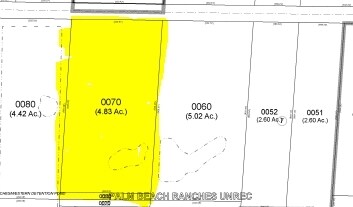
PALM BEACH RANCHES (UNREC) S 1/2 OF 50 FT CNL LYG N OF & ADJ TO LT 7 BLK 6
00-42-45-10-01-009-0070
PALM BEACH
Miscellaneous
Florida
AR
7
B and X Area of moderate flood hazard, usually the area between the limits of the 100-year and 500-year floods.
0.19 AC
2024
Boynton/Lantana
2025
South Florida
005918
NEARBY LISTINGS FOR SALE OR LEASE
DEMOGRAPHICS near Western Way
1 mile
3 mile
5 mile
2025 Total Population
9,968
121,198
312,986
2030 Population
10,365
127,062
329,466
Pop Growth 2025-2030
+ 3.98%
+ 4.84%
+ 5.27%
Average Age
40
44
44
2025 Total Households
3,439
44,860
120,556
HH Growth 2025-2030
+ 3.37%
+ 4.54%
+ 4.95%
Median Household Inc
$109,878
$93,000
$82,055
Avg Household Size
2.80
2.60
2.50
2025 Avg HH Vehicles
2.00
2.00
2.00
Median Home Value
$476,933
$434,660
$405,630
Median Year Built
1996
1992
1989
Nearby Places
Map Layers
Map Styles
 Street
 Aerial
Layers
 Traffic
 Biking
Places
Listings with unknown addresses are not visible on the map
- Restaurants
- Banks
- Shops
- Fitness
- Groceries
PUBLIC TRANSPORTATION
COMMUTER RAIL
Boynton Beach Station (Mangonia Park - Miami Airport - Tri-Rail)
Drive
Walk
Distance
Boynton Beach Station (Mangonia Park - Miami Airport - Tri-Rail)
16 min
7.1 mi
Lake Worth Beach Station (Mangonia Park - Miami Airport - Tri-Rail)
Drive
Walk
Distance
Lake Worth Beach Station (Mangonia Park - Miami Airport - Tri-Rail)
17 min
8.8 mi
AIRPORT
Palm Beach International
Drive
Walk
Distance
Palm Beach International
23 min
11.6 mi
Freight Ports
Port of Palm Beach
Drive
Walk
Distance
Port of Palm Beach
36 min
21.3 mi
Nearby Properties
Address
Land Use
TOTAL SIZE
Lot Size
Zoning
Address
Land Use
TOTAL SIZE
Lot Size
Zoning
436,808 SF
15.03 AC
MUPD
Address
Land Use
TOTAL SIZE
Lot Size
Zoning
441,081 SF
20.08 AC
PUD
Address
Land Use
TOTAL SIZE
Lot Size
Zoning
440,818 SF
47.57 AC
RS
Address
Land Use
TOTAL SIZE
Lot Size
Zoning
403,863 SF
24.14 AC
PUD
Address
Land Use
TOTAL SIZE
Lot Size
Zoning
429,061 SF
40.80 AC
PUD
Address
Land Use
TOTAL SIZE
Lot Size
Zoning
443,576 SF
92.86 AC
PO
Address
Land Use
TOTAL SIZE
Lot Size
Zoning
342,500 SF
33.52 AC
PUD
Address
Land Use
TOTAL SIZE
Lot Size
Zoning
296,278 SF
13.05 AC
PUD
Address
Land Use
TOTAL SIZE
Lot Size
Zoning
256,459 SF
12.24 AC
PUD
Address
Land Use
TOTAL SIZE
Lot Size
Zoning
251,365 SF
23.01 AC
CG
Address
Land Use
TOTAL SIZE
Lot Size
Zoning
188,100 SF
48.66 AC
GU
Address
Land Use
TOTAL SIZE
Lot Size
Zoning
231,894 SF
5.06 AC
CG
Address
Land Use
TOTAL SIZE
Lot Size
Zoning
91,115 SF
13.27 AC
CG
Address
Land Use
TOTAL SIZE
Lot Size
Zoning
216,113 SF
20.41 AC
CG
Address
Land Use
TOTAL SIZE
Lot Size
Zoning
146,426 SF
23.78 AC
AR
Address
Land Use
TOTAL SIZE
Lot Size
Zoning
113,918 SF
5.30 AC
CG
Address
Land Use
TOTAL SIZE
Lot Size
Zoning
160,199 SF
30 AC
RS
Address
Land Use
TOTAL SIZE
Lot Size
Zoning
51,988 SF
6.26 AC
CG
Address
Land Use
TOTAL SIZE
Lot Size
Zoning
134,221 SF
17.44 AC
MUPD
Address
Land Use
TOTAL SIZE
Lot Size
Zoning
189,393 SF
15 AC
RTS
Address
Land Use
TOTAL SIZE
Lot Size
Zoning
150,876 SF
5.65 AC
IL
Address
Land Use
TOTAL SIZE
Lot Size
Zoning
130,996 SF
24.96 AC
GU
Address
Land Use
TOTAL SIZE
Lot Size
Zoning
85,469 SF
33.33 AC
RTS
Address
Land Use
TOTAL SIZE
Lot Size
Zoning
120,480 SF
6.61 AC
RS
Address
Land Use
TOTAL SIZE
Lot Size
Zoning
71,191 SF
7.92 AC
CG
Address
Land Use
TOTAL SIZE
Lot Size
Zoning
129,570 SF
17.72 AC
PUD
Address
Land Use
TOTAL SIZE
Lot Size
Zoning
127,605 SF
17.88 AC
R1AA
Address
Land Use
TOTAL SIZE
Lot Size
Zoning
102,586 SF
10.62 AC
CG
Address
Land Use
TOTAL SIZE
Lot Size
Zoning
126,203 SF
20.96 AC
GU
Address
Land Use
TOTAL SIZE
Lot Size
Zoning
86,110 SF
11.06 AC
MUPD
The World's #1 Commercial Real Estate Marketplace
Connect with us
© 2026 CoStar Group
The information above has been obtained from sources believed reliable. While we do not doubt its accuracy we have not verified it and make no guarantee, warranty or representation about it. It is your responsibility to independently confirm its accuracy and completeness. Any projections, opinions, assumptions, or estimates used are for example only and do not represent the current or future performance of the property. The value of this transaction to you depends on tax and other factors which should be evaluated by your tax, financial, and legal advisors. You and your advisors should conduct a careful, independent investigation of the property to determine to your satisfaction the suitability of the property for your needs.