Property Record
Westover Dr, High Point, NC 27265
Property Detail
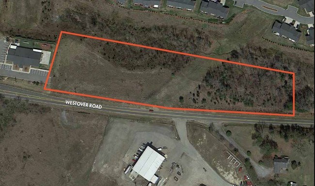
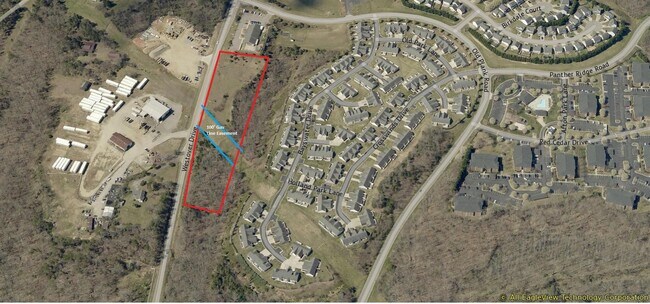
Westover Dr
01-007-0-000-0044-K-0-0
PB38-9 L44L BK2261-170 WESTOVER RD
Vacantlandnec
DAVIDSON
RA3
North Carolina
B and X Area of moderate flood hazard, usually the area between the limits of the 100-year and 500-year floods.
0.39 AC
2025
North Davidson County
2025
Greensboro/Winston-Salem
014409
Winston-Salem, NC
NEARBY LISTINGS FOR SALE OR LEASE
DEMOGRAPHICS near Westover Dr
1 mile
3 mile
5 mile
2024 Total Population
5,254
30,822
90,754
2029 Population
5,457
31,830
94,201
Pop Growth 2024-2029
+ 3.86%
+ 3.27%
+ 3.80%
Average Age
38
42
40
2024 Total Households
2,271
13,234
35,091
HH Growth 2024-2029
+ 4.01%
+ 3.37%
+ 4.05%
Median Household Inc
$68,100
$68,862
$60,331
Avg Household Size
2.30
2.30
2.40
2024 Avg HH Vehicles
2.00
2.00
2.00
Median Home Value
$244,483
$269,326
$253,414
Median Year Built
2002
1979
1979
Nearby Places
Map Layers
Map Styles
 Street
 Aerial
Transit
 Traffic
 Biking
Places
Listings with unknown addresses are not visible on the map
- Restaurants
- Banks
- Shops
- Fitness
- Groceries
PUBLIC TRANSPORTATION
COMMUTER RAIL
High Point Station (Piedmont - North Carolina by Train (NC Train))
Drive
Walk
Distance
High Point Station (Piedmont - North Carolina by Train (NC Train))
11 min
5.6 mi
AIRPORT
Piedmont Triad International
Drive
Walk
Distance
Piedmont Triad International
30 min
13.8 mi
Freight Ports
Port of Wilmington
Drive
Walk
Distance
Port of Wilmington
259 min
218.3 mi
SALE & LEASE HISTORY
LISTING DATE
SALE/LEASE

Sep 24, 2016
For Sale
Jul 28, 2023
For Sale
Nearby Properties
Address
Land Use
TOTAL SIZE
Lot Size
Zoning
Address
Land Use
TOTAL SIZE
Lot Size
Zoning
1,045,775 SF
114.96 AC
CZ-LI-HP
Address
Land Use
TOTAL SIZE
Lot Size
Zoning
25,648 SF
40.16 AC
PDR
Address
Land Use
TOTAL SIZE
Lot Size
Zoning
215,222 SF
15.14 AC
RC
Address
Land Use
TOTAL SIZE
Lot Size
Zoning
170,183 SF
13.94 AC
RM-16
Address
Land Use
TOTAL SIZE
Lot Size
Zoning
166,196 SF
19.99 AC
RM-16
Address
Land Use
TOTAL SIZE
Lot Size
Zoning
164,027 SF
12.52 AC
RM-16
Address
Land Use
TOTAL SIZE
Lot Size
Zoning
56,029 SF
9.36 AC
CU-GB
Address
Land Use
TOTAL SIZE
Lot Size
Zoning
161,377 SF
16.36 AC
CU-SC
Address
Land Use
TOTAL SIZE
Lot Size
Zoning
244,197 SF
14.76 AC
RM-26
Address
Land Use
TOTAL SIZE
Lot Size
Zoning
133,710 SF
8.70 AC
RM-16
Address
Land Use
TOTAL SIZE
Lot Size
Zoning
132,012 SF
12.99 AC
RM-16
Address
Land Use
TOTAL SIZE
Lot Size
Zoning
184,724 SF
15.71 AC
RM-16
Address
Land Use
TOTAL SIZE
Lot Size
Zoning
125,037 SF
13.89 AC
CU-GO-M
Address
Land Use
TOTAL SIZE
Lot Size
Zoning
74,786 SF
10.61 AC
GB
Address
Land Use
TOTAL SIZE
Lot Size
Zoning
28,210 SF
49.32 AC
RS
Address
Land Use
TOTAL SIZE
Lot Size
Zoning
666,462 SF
44.09 AC
RC
Address
Land Use
TOTAL SIZE
Lot Size
Zoning
67,497 SF
5.95 AC
RC
Address
Land Use
TOTAL SIZE
Lot Size
Zoning
110,750 SF
11.36 AC
GB
Address
Land Use
TOTAL SIZE
Lot Size
Zoning
146,216 SF
12.79 AC
RM-16
Address
Land Use
TOTAL SIZE
Lot Size
Zoning
99,064 SF
10 AC
RM-16
Address
Land Use
TOTAL SIZE
Lot Size
Zoning
119,536 SF
16.35 AC
RM-16
Address
Land Use
TOTAL SIZE
Lot Size
Zoning
96,744 SF
10.01 AC
RC
Address
Land Use
TOTAL SIZE
Lot Size
Zoning
49,972 SF
5.84 AC
GB
Address
Land Use
TOTAL SIZE
Lot Size
Zoning
79,700 SF
5.71 AC
CB
Address
Land Use
TOTAL SIZE
Lot Size
Zoning
74,954 SF
8.50 AC
RC
Address
Land Use
TOTAL SIZE
Lot Size
Zoning
62,686 SF
5.38 AC
GB
Address
Land Use
TOTAL SIZE
Lot Size
Zoning
96,693 SF
19.09 AC
PNR
Address
Land Use
TOTAL SIZE
Lot Size
Zoning
92,304 SF
10.57 AC
RM-16
Address
Land Use
TOTAL SIZE
Lot Size
Zoning
46,966 SF
7.15 AC
RC
Address
Land Use
TOTAL SIZE
Lot Size
Zoning
36,507 SF
6.97 AC
GB
The World's #1 Commercial Real Estate Marketplace
Connect with us
© 2026 CoStar Group
The information above has been obtained from sources believed reliable. While we do not doubt its accuracy we have not verified it and make no guarantee, warranty or representation about it. It is your responsibility to independently confirm its accuracy and completeness. Any projections, opinions, assumptions, or estimates used are for example only and do not represent the current or future performance of the property. The value of this transaction to you depends on tax and other factors which should be evaluated by your tax, financial, and legal advisors. You and your advisors should conduct a careful, independent investigation of the property to determine to your satisfaction the suitability of the property for your needs.