Property Record
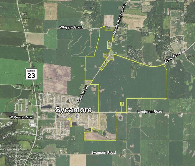
Whipple Rd, Sycamore, IL 60178
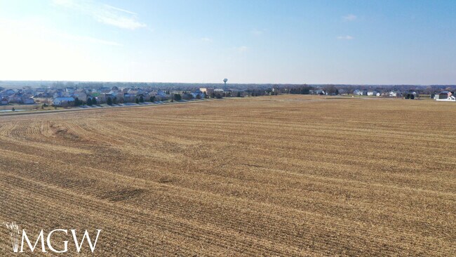
Property Detail
Whipple Rd
Chicago-Naperville-Elgin, IL-IN
PT LOTS 17, 15, 16, 18 & 19 - ASSESSORS LOTS OF SEC 15 ANDPT LOT D - DIVINE FARM PLAT SEC 15 - T41N R5E
06-10-300-021
DEKALB
Farms
Illinois
A1
15-19
B and X Area of moderate flood hazard, usually the area between the limits of the 100-year and 500-year floods.
2.09 AC
2023
Western East/West Corr
2024
Chicago
000600
NEARBY LISTINGS FOR SALE OR LEASE
-
-
View all Sycamore listings for sale on LoopNet.com
DEMOGRAPHICS near Whipple Rd
1 mile
3 mile
5 mile
2025 Total Population
1,633
10,332
22,784
2030 Population
1,636
10,358
22,860
Pop Growth 2025-2030
+ 0.18%
+ 0.25%
+ 0.33%
Average Age
37
39
40
2025 Total Households
535
4,009
8,982
HH Growth 2025-2030
+ 0.19%
+ 0.27%
+ 0.36%
Median Household Inc
$141,278
$100,806
$87,577
Avg Household Size
3.00
2.50
2.50
2025 Avg HH Vehicles
3.00
2.00
2.00
Median Home Value
$396,428
$310,139
$270,758
Median Year Built
2005
1998
1990
Nearby Places
Map Layers
Map Styles
 Street
 Aerial
Layers
 Traffic
 Biking
Places
Listings with unknown addresses are not visible on the map
- Restaurants
- Banks
- Shops
- Fitness
- Groceries
PUBLIC TRANSPORTATION
AIRPORT
Chicago/Rockford International
Drive
Walk
Distance
Chicago/Rockford International
57 min
33.7 mi
Freight Ports
Port Milwaukee
Drive
Walk
Distance
Port Milwaukee
133 min
94.7 mi
SALE & LEASE HISTORY
LISTING DATE
SALE/LEASE

Jan 04, 2023
For Sale
Apr 04, 2023
For Sale
Nearby Properties
Address
Land Use
TOTAL SIZE
Lot Size
Zoning
Address
Land Use
TOTAL SIZE
Lot Size
Zoning
8.41 AC
Address
Land Use
TOTAL SIZE
Lot Size
Zoning
33,876 SF
2.87 AC
A1
Address
Land Use
TOTAL SIZE
Lot Size
Zoning
4,622 SF
1.41 AC
Address
Land Use
TOTAL SIZE
Lot Size
Zoning
13,454 SF
2.26 AC
Address
Land Use
TOTAL SIZE
Lot Size
Zoning
5.30 AC
Address
Land Use
TOTAL SIZE
Lot Size
Zoning
4,707 SF
1.03 AC
Address
Land Use
TOTAL SIZE
Lot Size
Zoning
0.37 AC
Address
Land Use
TOTAL SIZE
Lot Size
Zoning
1,522 SF
0.85 AC
Address
Land Use
TOTAL SIZE
Lot Size
Zoning
4,164 SF
0.23 AC
Address
Land Use
TOTAL SIZE
Lot Size
Zoning
1,158 SF
0.84 AC
Address
Land Use
TOTAL SIZE
Lot Size
Zoning
8,360 SF
21.45 AC
A1
Address
Land Use
TOTAL SIZE
Lot Size
Zoning
4,748 SF
0.63 AC
Address
Land Use
TOTAL SIZE
Lot Size
Zoning
4,030 SF
0.54 AC
Address
Land Use
TOTAL SIZE
Lot Size
Zoning
251.23 AC
Address
Land Use
TOTAL SIZE
Lot Size
Zoning
1.74 AC
Address
Land Use
TOTAL SIZE
Lot Size
Zoning
1.60 AC
Address
Land Use
TOTAL SIZE
Lot Size
Zoning
160 AC
A1
Address
Land Use
TOTAL SIZE
Lot Size
Zoning
0.22 AC
A1
Address
Land Use
TOTAL SIZE
Lot Size
Zoning
154 AC
Address
Land Use
TOTAL SIZE
Lot Size
Zoning
157.50 AC
A1
Address
Land Use
TOTAL SIZE
Lot Size
Zoning
0.06 AC
PDR
Address
Land Use
TOTAL SIZE
Lot Size
Zoning
1.35 AC
Address
Land Use
TOTAL SIZE
Lot Size
Zoning
1,040 SF
241.49 AC
A1
Address
Land Use
TOTAL SIZE
Lot Size
Zoning
1.15 AC
Address
Land Use
TOTAL SIZE
Lot Size
Zoning
0.23 AC
Address
Land Use
TOTAL SIZE
Lot Size
Zoning
117.42 AC
Address
Land Use
TOTAL SIZE
Lot Size
Zoning
132.50 AC
A1
Address
Land Use
TOTAL SIZE
Lot Size
Zoning
113.71 AC
A1
Address
Land Use
TOTAL SIZE
Lot Size
Zoning
135.19 AC
A1
Address
Land Use
TOTAL SIZE
Lot Size
Zoning
121.67 AC
A1
The World's #1 Commercial Real Estate Marketplace
Connect with us
© 2026 CoStar Group
The information above has been obtained from sources believed reliable. While we do not doubt its accuracy we have not verified it and make no guarantee, warranty or representation about it. It is your responsibility to independently confirm its accuracy and completeness. Any projections, opinions, assumptions, or estimates used are for example only and do not represent the current or future performance of the property. The value of this transaction to you depends on tax and other factors which should be evaluated by your tax, financial, and legal advisors. You and your advisors should conduct a careful, independent investigation of the property to determine to your satisfaction the suitability of the property for your needs.