Property Record
Whiptail Loop, Carlsbad, CA 92010

Property Detail
Whiptail Loop
San Diego-Chula Vista-Carlsbad, CA
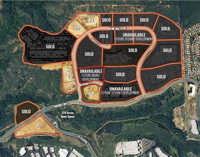
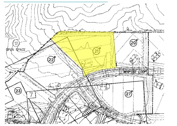
LOT 22 LOTS 21 THRU TR 016145
209-120-23
SAN DIEGO
Commercialacreage
California
P-M
22,21
B and X Area of moderate flood hazard, usually the area between the limits of the 100-year and 500-year floods.
8.37 AC
2024
Carlsbad
2025
San Diego
019811
NEARBY LISTINGS FOR SALE OR LEASE
DEMOGRAPHICS near Whiptail Loop
1 mile
3 mile
5 mile
2024 Total Population
3,046
82,350
277,826
2029 Population
3,029
82,612
278,872
Pop Growth 2024-2029
(0.56%)
+ 0.32%
+ 0.38%
Average Age
43
44
41
2024 Total Households
1,135
31,375
98,228
HH Growth 2024-2029
(0.70%)
+ 0.19%
+ 0.27%
Median Household Inc
$129,291
$113,463
$116,752
Avg Household Size
2.60
2.60
2.70
2024 Avg HH Vehicles
2.00
2.00
2.00
Median Home Value
$837,524
$922,827
$940,914
Median Year Built
1991
1990
1986
Nearby Places
Map Layers
Map Styles
 Street
 Aerial
Transit
 Traffic
 Biking
Places
Listings with unknown addresses are not visible on the map
- Restaurants
- Banks
- Shops
- Fitness
- Groceries
PUBLIC TRANSPORTATION
COMMUTER RAIL
Carlsbad Poinsettia (Coaster - San Diego North County Transit District (Coaster/Sprinter/Breeze))
Drive
Walk
Distance
Carlsbad Poinsettia (Coaster - San Diego North County Transit District (Coaster/Sprinter/Breeze))
14 min
6.9 mi
Carlsbad Village (Coaster - San Diego North County Transit District (Coaster/Sprinter/Breeze))
Drive
Walk
Distance
Carlsbad Village (Coaster - San Diego North County Transit District (Coaster/Sprinter/Breeze))
15 min
7.2 mi
AIRPORT
San Diego International
Drive
Walk
Distance
San Diego International
46 min
33.8 mi
Freight Ports
Port of San Diego
Drive
Walk
Distance
Port of San Diego
51 min
38.1 mi
SALE & LEASE HISTORY
LISTING DATE
SALE/LEASE

Sep 24, 2016
For Sale
Jan 30, 2017
For Sale
Nearby Properties
Address
Land Use
TOTAL SIZE
Lot Size
Zoning
Address
Land Use
TOTAL SIZE
Lot Size
Zoning
13.92 AC
P-M
Address
Land Use
TOTAL SIZE
Lot Size
Zoning
24.15 AC
RM-B
Address
Land Use
TOTAL SIZE
Lot Size
Zoning
18.90 AC
R-M
Address
Land Use
TOTAL SIZE
Lot Size
Zoning
8.76 AC
P-C
Address
Land Use
TOTAL SIZE
Lot Size
Zoning
14.32 AC
P-M
Address
Land Use
TOTAL SIZE
Lot Size
Zoning
7.31 AC
P-C
Address
Land Use
TOTAL SIZE
Lot Size
Zoning
28.15 AC
C-M
Address
Land Use
TOTAL SIZE
Lot Size
Zoning
12.49 AC
P-C
Address
Land Use
TOTAL SIZE
Lot Size
Zoning
16.79 AC
R-3-Q
Address
Land Use
TOTAL SIZE
Lot Size
Zoning
10.96 AC
C-M
Address
Land Use
TOTAL SIZE
Lot Size
Zoning
13.86 AC
C-M
Address
Land Use
TOTAL SIZE
Lot Size
Zoning
13.07 AC
P-M
Address
Land Use
TOTAL SIZE
Lot Size
Zoning
9.65 AC
P-C
Address
Land Use
TOTAL SIZE
Lot Size
Zoning
18.34 AC
P-C
Address
Land Use
TOTAL SIZE
Lot Size
Zoning
11.87 AC
R-M
Address
Land Use
TOTAL SIZE
Lot Size
Zoning
9.41 AC
SPI
Address
Land Use
TOTAL SIZE
Lot Size
Zoning
69,200 SF
4.52 AC
P-M
Address
Land Use
TOTAL SIZE
Lot Size
Zoning
11.08 AC
SPI
Address
Land Use
TOTAL SIZE
Lot Size
Zoning
11.49 AC
P-M
Address
Land Use
TOTAL SIZE
Lot Size
Zoning
14.91 AC
SPI
Address
Land Use
TOTAL SIZE
Lot Size
Zoning
14.73 AC
C-L
Address
Land Use
TOTAL SIZE
Lot Size
Zoning
4.76 AC
C34
Address
Land Use
TOTAL SIZE
Lot Size
Zoning
10.94 AC
P-M
Address
Land Use
TOTAL SIZE
Lot Size
Zoning
11.10 AC
RD-M-Q
Address
Land Use
TOTAL SIZE
Lot Size
Zoning
13.20 AC
P-M
Address
Land Use
TOTAL SIZE
Lot Size
Zoning
7.42 AC
P-M
Address
Land Use
TOTAL SIZE
Lot Size
Zoning
7.91 AC
SPI
Address
Land Use
TOTAL SIZE
Lot Size
Zoning
9.74 AC
C-M
Address
Land Use
TOTAL SIZE
Lot Size
Zoning
19.35 AC
P-M
Address
Land Use
TOTAL SIZE
Lot Size
Zoning
27.30 AC
SPI
The World's #1 Commercial Real Estate Marketplace
Connect with us
© 2026 CoStar Group
The information above has been obtained from sources believed reliable. While we do not doubt its accuracy we have not verified it and make no guarantee, warranty or representation about it. It is your responsibility to independently confirm its accuracy and completeness. Any projections, opinions, assumptions, or estimates used are for example only and do not represent the current or future performance of the property. The value of this transaction to you depends on tax and other factors which should be evaluated by your tax, financial, and legal advisors. You and your advisors should conduct a careful, independent investigation of the property to determine to your satisfaction the suitability of the property for your needs.