No Photo
Property Record
White Oaks Rd, Laconia, NH 03246
NEARBY LISTINGS FOR SALE OR LEASE
-
-
View all Laconia listings for sale on LoopNet.com
Property Detail
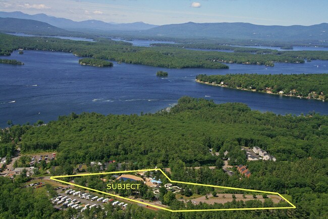
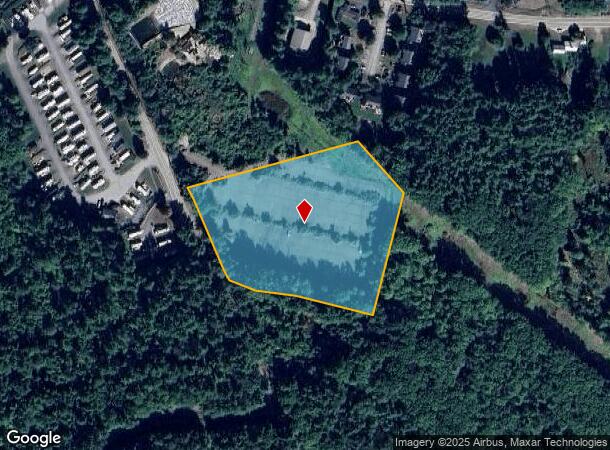
White Oaks Rd
Laconia, NH
Belknap
LACO-000172-000241-000003
New Hampshire
Parkinglot
3
2024
4.60 AC
2024
Concord/New Hampshire North Area
966100
Other Market Areas
DEMOGRAPHICS near White Oaks Rd
1 Mile
3 Mile
5 Mile
2024 Total Population
2,019
8,608
24,282
2029 Population
2,285
9,558
25,871
Pop Growth 2024-2029
+ 13.17%
+ 11.04%
+ 6.54%
Average Age
52
51
48
2024 Total Households
1,031
4,150
10,872
HH Growth 2024-2029
+ 12.90%
+ 10.94%
+ 6.52%
Median Household Inc
$117,719
$102,352
$79,120
Avg Household Size
2.00
2.10
2.20
2024 Avg HH Vehicles
2.00
2.00
2.00
Median Home Value
$379,736
$384,572
$351,684
Median Year Built
1985
1984
1980
Nearby Places
Map Layers
Map Styles
 Street
 Aerial
- Restaurants
- Banks
- Shops
- Fitness
- Groceries
SALE & LEASE HISTORY
LISTING DATE
SALE/LEASE

Sep 24, 2016
For Sale
Feb 27, 2017
For Sale
Dec 03, 2024
For Sale
Nearby Properties
Address
Land Use
TOTAL SIZE
Lot Size
Zoning
Address
Land Use
TOTAL SIZE
Lot Size
Zoning
57.90 AC
C
Address
Land Use
TOTAL SIZE
Lot Size
Zoning
Address
Land Use
TOTAL SIZE
Lot Size
Zoning
21.50 AC
C
Address
Land Use
TOTAL SIZE
Lot Size
Zoning
112.60 AC
S
Address
Land Use
TOTAL SIZE
Lot Size
Zoning
9.63 AC
C
Address
Land Use
TOTAL SIZE
Lot Size
Zoning
14.48 AC
RA
Address
Land Use
TOTAL SIZE
Lot Size
Zoning
343.45 AC
I
Address
Land Use
TOTAL SIZE
Lot Size
Zoning
124.80 AC
RR1
Address
Land Use
TOTAL SIZE
Lot Size
Zoning
102.80 AC
RR1
Address
Land Use
TOTAL SIZE
Lot Size
Zoning
104,952 SF
5.10 AC
C
Address
Land Use
TOTAL SIZE
Lot Size
Zoning
0.62 AC
SFR
Address
Land Use
TOTAL SIZE
Lot Size
Zoning
15,086 SF
4.82 AC
CR
Address
Land Use
TOTAL SIZE
Lot Size
Zoning
8,318 SF
0.77 AC
SFR
Address
Land Use
TOTAL SIZE
Lot Size
Zoning
Address
Land Use
TOTAL SIZE
Lot Size
Zoning
10 AC
C
Address
Land Use
TOTAL SIZE
Lot Size
Zoning
1,600 SF
4.40 AC
CR
Address
Land Use
TOTAL SIZE
Lot Size
Zoning
1.06 AC
S
Address
Land Use
TOTAL SIZE
Lot Size
Zoning
528 SF
17 AC
UC
Address
Land Use
TOTAL SIZE
Lot Size
Zoning
1.60 AC
SFR
Address
Land Use
TOTAL SIZE
Lot Size
Zoning
63,078 SF
25.42 AC
Address
Land Use
TOTAL SIZE
Lot Size
Zoning
2,860 SF
1.70 AC
SFR
Address
Land Use
TOTAL SIZE
Lot Size
Zoning
1,279 SF
1.91 AC
S
Address
Land Use
TOTAL SIZE
Lot Size
Zoning
6.60 AC
SFR
Address
Land Use
TOTAL SIZE
Lot Size
Zoning
968 SF
1.39 AC
SFR
Address
Land Use
TOTAL SIZE
Lot Size
Zoning
5,674 SF
1.60 AC
CR
Address
Land Use
TOTAL SIZE
Lot Size
Zoning
4,345 SF
1.10 AC
SFR
Address
Land Use
TOTAL SIZE
Lot Size
Zoning
6,070 SF
0.80 AC
SFR
Address
Land Use
TOTAL SIZE
Lot Size
Zoning
4.50 AC
RC
Address
Land Use
TOTAL SIZE
Lot Size
Zoning
17 AC
RC
Address
Land Use
TOTAL SIZE
Lot Size
Zoning
7.23 AC
S
The World's #1 Commercial Real Estate Marketplace
Connect with us
© 2025 CoStar Group
The information above has been obtained from sources believed reliable. While we do not doubt its accuracy we have not verified it and make no guarantee, warranty or representation about it. It is your responsibility to independently confirm its accuracy and completeness. Any projections, opinions, assumptions, or estimates used are for example only and do not represent the current or future performance of the property. The value of this transaction to you depends on tax and other factors which should be evaluated by your tax, financial, and legal advisors. You and your advisors should conduct a careful, independent investigation of the property to determine to your satisfaction the suitability of the property for your needs.