No Photo
Property Record
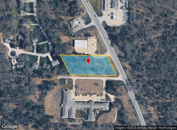
Whitehall Rd, Whitehall, MI 49461
NEARBY LISTINGS FOR SALE OR LEASE
-
-
View all Whitehall listings for sale on LoopNet.com
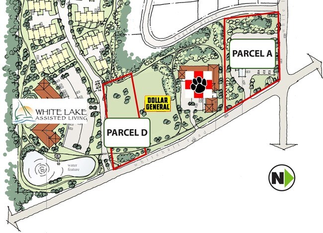
Property Detail
Whitehall Rd
Muskegon, MI
Woodhaven Estates
06-101-100-0002-04
SOME INFO KEYED FROM LEGAL DESCRIPTION, BUT COMPLETE LEGAL NOT CAPTURED
Commercialacreage
Muskegon
X
Michigan
26121C0050D
2.04 AC
2024
Northern Muskegon County
2025
West Michigan
003702
DEMOGRAPHICS near Whitehall Rd
1 Mile
3 Mile
5 Mile
2024 Total Population
677
6,498
16,927
2029 Population
689
6,567
17,213
Pop Growth 2024-2029
+ 1.77%
+ 1.06%
+ 1.69%
Average Age
42
41
42
2024 Total Households
249
2,442
6,615
HH Growth 2024-2029
+ 2.01%
+ 1.02%
+ 1.74%
Median Household Inc
$58,703
$57,254
$63,954
Avg Household Size
2.60
2.60
2.50
2024 Avg HH Vehicles
2.00
2.00
2.00
Median Home Value
$177,127
$169,967
$185,363
Median Year Built
1989
1983
1978
Nearby Places
Map Layers
Map Styles
 Street
 Aerial
- Restaurants
- Banks
- Shops
- Fitness
- Groceries
SALE & LEASE HISTORY
LISTING DATE
SALE/LEASE

Sep 24, 2016
For Sale
Nearby Properties
Address
Land Use
TOTAL SIZE
Lot Size
Zoning
Address
Land Use
TOTAL SIZE
Lot Size
Zoning
620,456 SF
127.38 AC
M-2 GEN
Address
Land Use
TOTAL SIZE
Lot Size
Zoning
114,654 SF
83.75 AC
AP AMUS
Address
Land Use
TOTAL SIZE
Lot Size
Zoning
126,901 SF
30.35 AC
B COM
Address
Land Use
TOTAL SIZE
Lot Size
Zoning
117,661 SF
14.70 AC
M-1 LIM
Address
Land Use
TOTAL SIZE
Lot Size
Zoning
114,008 SF
R - 1
Address
Land Use
TOTAL SIZE
Lot Size
Zoning
44,844 SF
7.83 AC
NC
Address
Land Use
TOTAL SIZE
Lot Size
Zoning
52,111 SF
R - 1
Address
Land Use
TOTAL SIZE
Lot Size
Zoning
14,418 SF
2.50 AC
MI LIMI
Address
Land Use
TOTAL SIZE
Lot Size
Zoning
32,945 SF
14.70 AC
Address
Land Use
TOTAL SIZE
Lot Size
Zoning
75,575 SF
5 AC
M-1 LIM
Address
Land Use
TOTAL SIZE
Lot Size
Zoning
41,187 SF
1.50 AC
B COM
Address
Land Use
TOTAL SIZE
Lot Size
Zoning
37,041 SF
12.18 AC
R-1 RES
Address
Land Use
TOTAL SIZE
Lot Size
Zoning
27,205 SF
3.68 AC
B COM
Address
Land Use
TOTAL SIZE
Lot Size
Zoning
32,717 SF
R - 1
Address
Land Use
TOTAL SIZE
Lot Size
Zoning
35,320 SF
10.88 AC
R-3 RES
Address
Land Use
TOTAL SIZE
Lot Size
Zoning
41,390 SF
9.54 AC
MI LIMI
Address
Land Use
TOTAL SIZE
Lot Size
Zoning
37,368 SF
2.80 AC
B COM
Address
Land Use
TOTAL SIZE
Lot Size
Zoning
78,066 SF
15.24 AC
B COM
Address
Land Use
TOTAL SIZE
Lot Size
Zoning
34,825 SF
6.77 AC
M-1 LIM
Address
Land Use
TOTAL SIZE
Lot Size
Zoning
15,846 SF
1.54 AC
B-1 GEN
Address
Land Use
TOTAL SIZE
Lot Size
Zoning
30,300 SF
R - 1
Address
Land Use
TOTAL SIZE
Lot Size
Zoning
41,969 SF
3.26 AC
R-3 RES
Address
Land Use
TOTAL SIZE
Lot Size
Zoning
5,232 SF
118.84 AC
C2-REG COM
Address
Land Use
TOTAL SIZE
Lot Size
Zoning
39,696 SF
3.09 AC
R-3 RES
Address
Land Use
TOTAL SIZE
Lot Size
Zoning
14,418 SF
2.79 AC
R - 1
Address
Land Use
TOTAL SIZE
Lot Size
Zoning
9,487 SF
2.66 AC
M-1 LIM
Address
Land Use
TOTAL SIZE
Lot Size
Zoning
13,217 SF
1.10 AC
R-3 RES
Address
Land Use
TOTAL SIZE
Lot Size
Zoning
30,300 SF
2.52 AC
Address
Land Use
TOTAL SIZE
Lot Size
Zoning
5,136 SF
2.90 AC
NC
Address
Land Use
TOTAL SIZE
Lot Size
Zoning
3,923 SF
1.11 AC
The World's #1 Commercial Real Estate Marketplace
Connect with us
© 2025 CoStar Group
The information above has been obtained from sources believed reliable. While we do not doubt its accuracy we have not verified it and make no guarantee, warranty or representation about it. It is your responsibility to independently confirm its accuracy and completeness. Any projections, opinions, assumptions, or estimates used are for example only and do not represent the current or future performance of the property. The value of this transaction to you depends on tax and other factors which should be evaluated by your tax, financial, and legal advisors. You and your advisors should conduct a careful, independent investigation of the property to determine to your satisfaction the suitability of the property for your needs.