No Photo
Property Record
Wicker St, Ticonderoga, NY 12883
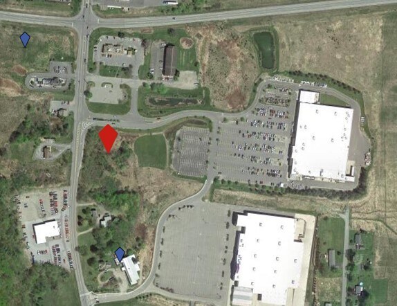
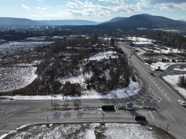
Property Detail
Wicker St
154800-150-002-0003-003-000-0000
ESSEX
Residentialacreage
New York
02 - SINGL
3.000
2025
0.49 AC
2025
Ticonderoga
961201
Other Market Areas
NEARBY LISTINGS FOR SALE OR LEASE
-
-
View all Ticonderoga listings for sale on LoopNet.com
DEMOGRAPHICS near Wicker St
1 mile
3 mile
5 mile
2025 Total Population
1,907
4,216
5,251
2030 Population
1,873
4,234
5,298
Pop Growth 2025-2030
(1.78%)
+ 0.43%
+ 0.90%
Average Age
42
44
44
2025 Total Households
787
1,741
2,179
HH Growth 2025-2030
(2.03%)
+ 0.11%
+ 0.60%
Median Household Inc
$52,756
$58,205
$61,588
Avg Household Size
2.30
2.30
2.30
2025 Avg HH Vehicles
2.00
2.00
2.00
Median Home Value
$159,665
$175,362
$183,925
Median Year Built
1947
1956
1960
Nearby Places
Map Layers
Map Styles
 Street
 Aerial
Layers
 Traffic
 Biking
Places
Listings with unknown addresses are not visible on the map
- Restaurants
- Banks
- Shops
- Fitness
- Groceries
PUBLIC TRANSPORTATION
COMMUTER RAIL
Ticonderoga Amtrak (Adirondack - Amtrak)
Drive
Walk
Distance
Ticonderoga Amtrak (Adirondack - Amtrak)
4 min
3.0 mi
Freight Ports
Albany, NY Port
Drive
Walk
Distance
Albany, NY Port
141 min
100.1 mi
SALE & LEASE HISTORY
LISTING DATE
SALE/LEASE

Mar 16, 2023
For Lease
Feb 05, 2025
For Sale
Nearby Properties
Address
Land Use
TOTAL SIZE
Lot Size
Zoning
Address
Land Use
TOTAL SIZE
Lot Size
Zoning
242,734 SF
531.30 AC
06 - INDUS
Address
Land Use
TOTAL SIZE
Lot Size
Zoning
5,470 SF
114.50 AC
07 - MIXED
Address
Land Use
TOTAL SIZE
Lot Size
Zoning
93,641 SF
6.70 AC
07 - MIXED
Address
Land Use
TOTAL SIZE
Lot Size
Zoning
100,315 SF
45.14 AC
07 - MIXED
Address
Land Use
TOTAL SIZE
Lot Size
Zoning
85.01 AC
04 - FARM
Address
Land Use
TOTAL SIZE
Lot Size
Zoning
13.89 AC
04 - FARM
Address
Land Use
TOTAL SIZE
Lot Size
Zoning
04 - FARM
Address
Land Use
TOTAL SIZE
Lot Size
Zoning
04 - FARM
Address
Land Use
TOTAL SIZE
Lot Size
Zoning
Address
Land Use
TOTAL SIZE
Lot Size
Zoning
29,031 SF
10.60 AC
07 - MIXED
Address
Land Use
TOTAL SIZE
Lot Size
Zoning
115,411 SF
19.45 AC
05 - COMME
Address
Land Use
TOTAL SIZE
Lot Size
Zoning
124,051 SF
25.53 AC
07 - MIXED
Address
Land Use
TOTAL SIZE
Lot Size
Zoning
10 AC
01 - NOT Z
Address
Land Use
TOTAL SIZE
Lot Size
Zoning
20.93 AC
07 - MIXED
Address
Land Use
TOTAL SIZE
Lot Size
Zoning
7,809 SF
3.70 AC
07 - MIXED
Address
Land Use
TOTAL SIZE
Lot Size
Zoning
0.76 AC
05 - COMME
Address
Land Use
TOTAL SIZE
Lot Size
Zoning
40,367 SF
4.40 AC
07 - MIXED
Address
Land Use
TOTAL SIZE
Lot Size
Zoning
17,988 SF
5.92 AC
07 - MIXED
Address
Land Use
TOTAL SIZE
Lot Size
Zoning
2,480 SF
24.73 AC
07 - MIXED
Address
Land Use
TOTAL SIZE
Lot Size
Zoning
5,570 SF
155.10 AC
07 - MIXED
Address
Land Use
TOTAL SIZE
Lot Size
Zoning
6,674 SF
0.78 AC
05 - COMME
Address
Land Use
TOTAL SIZE
Lot Size
Zoning
3.40 AC
01 - NOT Z
Address
Land Use
TOTAL SIZE
Lot Size
Zoning
7,412 SF
0.73 AC
02 - SINGL
Address
Land Use
TOTAL SIZE
Lot Size
Zoning
13,896 SF
2 AC
07 - MIXED
Address
Land Use
TOTAL SIZE
Lot Size
Zoning
13 AC
07 - MIXED
Address
Land Use
TOTAL SIZE
Lot Size
Zoning
11,536 SF
6.50 AC
07 - MIXED
Address
Land Use
TOTAL SIZE
Lot Size
Zoning
9,491 SF
1.29 AC
07 - MIXED
Address
Land Use
TOTAL SIZE
Lot Size
Zoning
10.80 AC
02 - SINGL
Address
Land Use
TOTAL SIZE
Lot Size
Zoning
13,596 SF
1.98 AC
07 - MIXED
Address
Land Use
TOTAL SIZE
Lot Size
Zoning
3,121 SF
1.06 AC
02 - SINGL
The World's #1 Commercial Real Estate Marketplace
Connect with us
© 2026 CoStar Group
The information above has been obtained from sources believed reliable. While we do not doubt its accuracy we have not verified it and make no guarantee, warranty or representation about it. It is your responsibility to independently confirm its accuracy and completeness. Any projections, opinions, assumptions, or estimates used are for example only and do not represent the current or future performance of the property. The value of this transaction to you depends on tax and other factors which should be evaluated by your tax, financial, and legal advisors. You and your advisors should conduct a careful, independent investigation of the property to determine to your satisfaction the suitability of the property for your needs.