Property Record
Wildcat Trl, , WI

Property Detail
Wildcat Trl
Green Bay
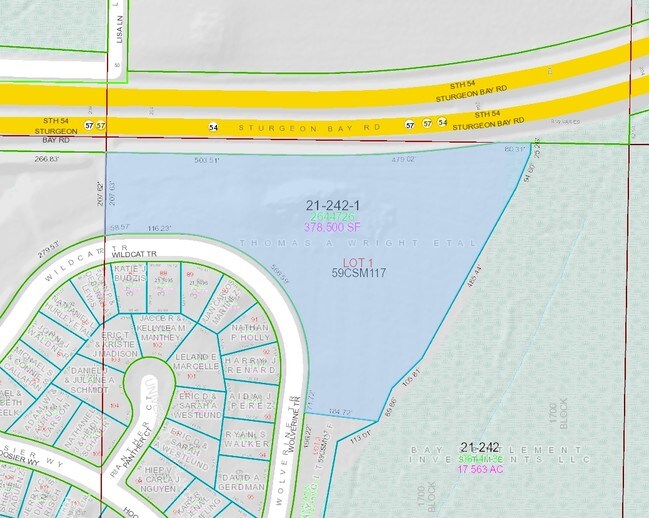
394,653 SQ FT LOT 1 OF 59 CSM 117 MAP 8409 IN 2660090 BNG PRT OF NW1/4 SE1/4 SEC 25 T24N R21E & PRT OF NW1/4 SE1/4 DESC IN 2726327
Green Bay, WI
BROWN
21-242-1
Wisconsin
Commercialnec
1
2025
9.06 AC
2025
Green Bay
020100
NEARBY LISTINGS FOR SALE OR LEASE
DEMOGRAPHICS near Wildcat Trl
1 mile
3 mile
5 mile
2025 Total Population
1,718
19,576
54,755
2030 Population
1,749
20,318
55,727
Pop Growth 2025-2030
+ 1.80%
+ 3.79%
+ 1.78%
Average Age
42
37
38
2025 Total Households
680
7,168
21,359
HH Growth 2025-2030
+ 1.76%
+ 4.67%
+ 2.03%
Median Household Inc
$93,402
$89,044
$71,501
Avg Household Size
2.50
2.40
2.40
2025 Avg HH Vehicles
2.00
2.00
2.00
Median Home Value
$342,631
$294,142
$256,202
Median Year Built
1995
1994
1983
Nearby Places
Map Layers
Map Styles
 Street
 Aerial
Transit
 Traffic
 Biking
Places
Listings with unknown addresses are not visible on the map
- Restaurants
- Banks
- Shops
- Fitness
- Groceries
PUBLIC TRANSPORTATION
AIRPORT
Green Bay/Austin Straubel International
Drive
Walk
Distance
Green Bay/Austin Straubel International
28 min
16.1 mi
Freight Ports
Port Milwaukee
Drive
Walk
Distance
Port Milwaukee
138 min
115.9 mi
Nearby Properties
Address
Land Use
TOTAL SIZE
Lot Size
Zoning
Address
Land Use
TOTAL SIZE
Lot Size
Zoning
3,368 SF
27.55 AC
C1, OR
Address
Land Use
TOTAL SIZE
Lot Size
Zoning
27.96 AC
Address
Land Use
TOTAL SIZE
Lot Size
Zoning
1,632 SF
30.52 AC
R1
Address
Land Use
TOTAL SIZE
Lot Size
Zoning
13.56 AC
C1, R3
Address
Land Use
TOTAL SIZE
Lot Size
Zoning
8.11 AC
Address
Land Use
TOTAL SIZE
Lot Size
Zoning
9.21 AC
Address
Land Use
TOTAL SIZE
Lot Size
Zoning
Address
Land Use
TOTAL SIZE
Lot Size
Zoning
Address
Land Use
TOTAL SIZE
Lot Size
Zoning
Address
Land Use
TOTAL SIZE
Lot Size
Zoning
9.06 AC
Address
Land Use
TOTAL SIZE
Lot Size
Zoning
Address
Land Use
TOTAL SIZE
Lot Size
Zoning
3.63 AC
Address
Land Use
TOTAL SIZE
Lot Size
Zoning
3.28 AC
Address
Land Use
TOTAL SIZE
Lot Size
Zoning
2.95 AC
C1
Address
Land Use
TOTAL SIZE
Lot Size
Zoning
Address
Land Use
TOTAL SIZE
Lot Size
Zoning
20,147 SF
5.50 AC
RR
Address
Land Use
TOTAL SIZE
Lot Size
Zoning
2.15 AC
Address
Land Use
TOTAL SIZE
Lot Size
Zoning
4.04 AC
Address
Land Use
TOTAL SIZE
Lot Size
Zoning
Address
Land Use
TOTAL SIZE
Lot Size
Zoning
2.53 AC
Address
Land Use
TOTAL SIZE
Lot Size
Zoning
1,055 SF
1.83 AC
OR, R1
Address
Land Use
TOTAL SIZE
Lot Size
Zoning
3.22 AC
C1, R3
Address
Land Use
TOTAL SIZE
Lot Size
Zoning
27,936 SF
2.57 AC
R3, RR
Address
Land Use
TOTAL SIZE
Lot Size
Zoning
6.06 AC
Address
Land Use
TOTAL SIZE
Lot Size
Zoning
1,150 SF
2.20 AC
R1
Address
Land Use
TOTAL SIZE
Lot Size
Zoning
1.88 AC
Address
Land Use
TOTAL SIZE
Lot Size
Zoning
3.47 AC
Address
Land Use
TOTAL SIZE
Lot Size
Zoning
Address
Land Use
TOTAL SIZE
Lot Size
Zoning
4.82 AC
Address
Land Use
TOTAL SIZE
Lot Size
Zoning
6.03 AC
The World's #1 Commercial Real Estate Marketplace
Connect with us
© 2026 CoStar Group
The information above has been obtained from sources believed reliable. While we do not doubt its accuracy we have not verified it and make no guarantee, warranty or representation about it. It is your responsibility to independently confirm its accuracy and completeness. Any projections, opinions, assumptions, or estimates used are for example only and do not represent the current or future performance of the property. The value of this transaction to you depends on tax and other factors which should be evaluated by your tax, financial, and legal advisors. You and your advisors should conduct a careful, independent investigation of the property to determine to your satisfaction the suitability of the property for your needs.