Property Record
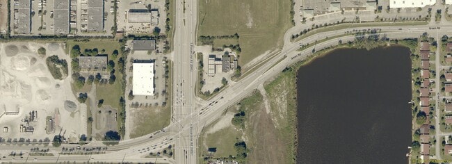
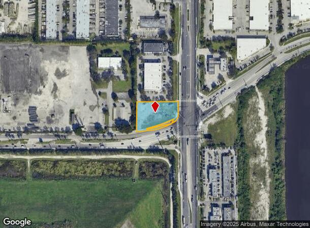
Wiles Rd, Deerfield Beach, FL 33442
Current Lease Availabilities
NEARBY LISTINGS FOR SALE OR LEASE
Property Detail
Wiles Rd
Fort Lauderdale-Pompano Beach-Sunrise, FL
York Chase Ronto Commercial Plat
48-42-09-04-0030
YORK CHASE RONTO COMMERCIAL PLAT 123-28 B PORTION PARCEL A DESC AS BEG AT SW COR PAR A,N 203.09,E 286.01,S 103.39,SW 33.58,SWLY 261.27,W 22.64 TO POB,LESS POR DESC AS PARCEL 33 PER ORT 37533/486
Industrialacreage
Broward
X
Florida
12099C1175F
1.12 AC
2025
Pompano Beach
2026
South Florida
010403
DEMOGRAPHICS near Wiles Rd
1 Mile
3 Mile
5 Mile
2024 Total Population
6,592
128,494
369,417
2029 Population
6,496
128,510
372,444
Pop Growth 2024-2029
(1.46%)
+ 0.01%
+ 0.82%
Average Age
39
44
43
2024 Total Households
2,525
53,531
152,145
HH Growth 2024-2029
(2.22%)
+ 0.32%
+ 0.87%
Median Household Inc
$65,119
$53,769
$60,292
Avg Household Size
2.40
2.30
2.30
2024 Avg HH Vehicles
2.00
1.00
2.00
Median Home Value
$258,218
$229,597
$315,953
Median Year Built
1983
1983
1981
Nearby Places
Map Layers
Map Styles
 Street
 Aerial
- Restaurants
- Banks
- Shops
- Fitness
- Groceries
PUBLIC TRANSPORTATION
COMMUTER RAIL
Pompano Beach (Tri-County Commuter - South Florida Regional Transportation Authority (Tri-Rail))
DRIVE
WALK
Distance
Pompano Beach (Tri-County Commuter - South Florida Regional Transportation Authority (Tri-Rail))
6 min
2.7 mi
Deerfield Beach (Tri-County Commuter - South Florida Regional Transportation Authority (Tri-Rail))
DRIVE
WALK
Distance
Deerfield Beach (Tri-County Commuter - South Florida Regional Transportation Authority (Tri-Rail))
9 min
3.8 mi
AIRPORT
Fort Lauderdale/Hollywood International
DRIVE
WALK
Distance
Fort Lauderdale/Hollywood International
28 min
19.0 mi
Palm Beach International
DRIVE
WALK
Distance
Palm Beach International
45 min
33.1 mi
Nearby Properties
Address
Land Use
TOTAL SIZE
Lot Size
Zoning
Address
Land Use
TOTAL SIZE
Lot Size
Zoning
605,126 SF
39.63 AC
I
Address
Land Use
TOTAL SIZE
Lot Size
Zoning
680,226 SF
42.13 AC
RM-15
Address
Land Use
TOTAL SIZE
Lot Size
Zoning
696,020 SF
31.74 AC
OPC
Address
Land Use
TOTAL SIZE
Lot Size
Zoning
1,166,083 SF
74.07 AC
I
Address
Land Use
TOTAL SIZE
Lot Size
Zoning
32,538 SF
331.51 AC
P
Address
Land Use
TOTAL SIZE
Lot Size
Zoning
467,722 SF
36.71 AC
I-1
Address
Land Use
TOTAL SIZE
Lot Size
Zoning
356,704 SF
11.84 AC
PCD
Address
Land Use
TOTAL SIZE
Lot Size
Zoning
377,588 SF
44.94 AC
RM-10
Address
Land Use
TOTAL SIZE
Lot Size
Zoning
380,866 SF
26.23 AC
O-IP/PCD
Address
Land Use
TOTAL SIZE
Lot Size
Zoning
390,795 SF
16.83 AC
PUD
Address
Land Use
TOTAL SIZE
Lot Size
Zoning
340,604 SF
31.31 AC
B-2
Address
Land Use
TOTAL SIZE
Lot Size
Zoning
246,122 SF
6.92 AC
TOD
Address
Land Use
TOTAL SIZE
Lot Size
Zoning
533,078 SF
14.83 AC
RS
Address
Land Use
TOTAL SIZE
Lot Size
Zoning
307,641 SF
20 AC
PUD
Address
Land Use
TOTAL SIZE
Lot Size
Zoning
311,680 SF
15.84 AC
PUD
Address
Land Use
TOTAL SIZE
Lot Size
Zoning
447,948 SF
20.33 AC
RS
Address
Land Use
TOTAL SIZE
Lot Size
Zoning
548,682 SF
21.63 AC
CF
Address
Land Use
TOTAL SIZE
Lot Size
Zoning
325,343 SF
21.10 AC
PUD
Address
Land Use
TOTAL SIZE
Lot Size
Zoning
440,709 SF
22.39 AC
I
Address
Land Use
TOTAL SIZE
Lot Size
Zoning
374,776 SF
23.52 AC
I-1
Address
Land Use
TOTAL SIZE
Lot Size
Zoning
384,131 SF
17.84 AC
PMDD
Address
Land Use
TOTAL SIZE
Lot Size
Zoning
435,201 SF
23.78 AC
I-1
Address
Land Use
TOTAL SIZE
Lot Size
Zoning
275,724 SF
26.67 AC
TOC-G
Address
Land Use
TOTAL SIZE
Lot Size
Zoning
283,330 SF
27.02 AC
I-1/PCI
Address
Land Use
TOTAL SIZE
Lot Size
Zoning
269,508 SF
38.46 AC
A-1
Address
Land Use
TOTAL SIZE
Lot Size
Zoning
254,235 SF
25.40 AC
RM-10
Address
Land Use
TOTAL SIZE
Lot Size
Zoning
206,194 SF
20.06 AC
RM-10
Address
Land Use
TOTAL SIZE
Lot Size
Zoning
313,030 SF
37.22 AC
CF
Address
Land Use
TOTAL SIZE
Lot Size
Zoning
214,164 SF
11.31 AC
PUD
Address
Land Use
TOTAL SIZE
Lot Size
Zoning
224,769 SF
15.48 AC
I-1
The World's #1 Commercial Real Estate Marketplace
Connect with us
© 2026 CoStar Group
The information above has been obtained from sources believed reliable. While we do not doubt its accuracy we have not verified it and make no guarantee, warranty or representation about it. It is your responsibility to independently confirm its accuracy and completeness. Any projections, opinions, assumptions, or estimates used are for example only and do not represent the current or future performance of the property. The value of this transaction to you depends on tax and other factors which should be evaluated by your tax, financial, and legal advisors. You and your advisors should conduct a careful, independent investigation of the property to determine to your satisfaction the suitability of the property for your needs.