Property Record
Will Carleton Rd, Flat Rock, MI 48134

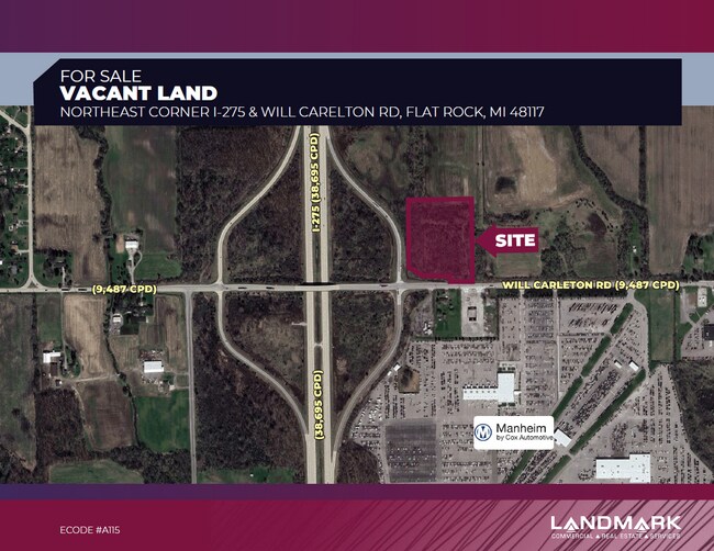

This Property Is For Sale
Property Detail
Will Carleton Rd
Detroit-Warren-Dearborn, MI
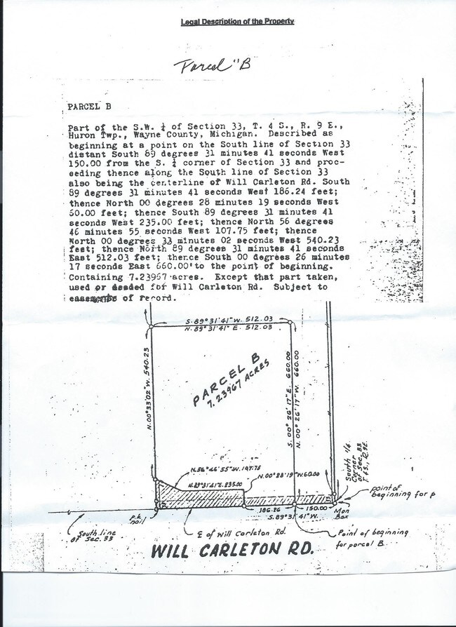
33Q1B PT OF SW 1/4 SEC 33 T4S R9E BEG S89DEG 31M 41S W 150FT FROM S 1/4 COR SEC 33 TH S89DEG 31M 41S W 186.24FT TH N0DEG 28M 19S W 60FT TH S89DEG 31M 41S W 235 FT TH N56DEG 46M 55S W 107.75FT TH N0DEG 33M 02S W 540.23FT TH N89DEG 31M 41S E 512.03FT T
75-131-99-0008-002
WAYNE
Commercialacreage
Michigan
B2 GENE
0008
B and X Area of moderate flood hazard, usually the area between the limits of the 100-year and 500-year floods.
7.10 AC
2024
Airport District
2025
Detroit
599001
NEARBY LISTINGS FOR SALE OR LEASE
DEMOGRAPHICS near Will Carleton Rd
1 mile
3 mile
5 mile
2025 Total Population
391
9,654
31,342
2030 Population
386
9,580
31,135
Pop Growth 2025-2030
(1.28%)
(0.77%)
(0.66%)
Average Age
43
41
43
2025 Total Households
145
3,607
12,090
HH Growth 2025-2030
(1.38%)
(0.58%)
(0.59%)
Median Household Inc
$116,964
$93,317
$85,100
Avg Household Size
2.70
2.60
2.60
2025 Avg HH Vehicles
2.00
2.00
2.00
Median Home Value
$347,183
$320,023
$309,619
Median Year Built
1990
1993
1989
Nearby Places
Map Layers
Map Styles
 Street
 Aerial
Transit
 Traffic
 Biking
Places
Listings with unknown addresses are not visible on the map
- Restaurants
- Banks
- Shops
- Fitness
- Groceries
PUBLIC TRANSPORTATION
AIRPORT
Detroit Metro Wayne County
Drive
Walk
Distance
Detroit Metro Wayne County
13 min
9.9 mi
Windsor International
Drive
Walk
Distance
Windsor International
57 min
35.4 mi
Freight Ports
Port of Toledo
Drive
Walk
Distance
Port of Toledo
49 min
38.2 mi
Nearby Properties
Address
Land Use
TOTAL SIZE
Lot Size
Zoning
Address
Land Use
TOTAL SIZE
Lot Size
Zoning
323,057 SF
Address
Land Use
TOTAL SIZE
Lot Size
Zoning
323,057 SF
39.75 AC
I3 PLAN
Address
Land Use
TOTAL SIZE
Lot Size
Zoning
169,300 SF
229.95 AC
Address
Land Use
TOTAL SIZE
Lot Size
Zoning
285,251 SF
17.27 AC
I3 PLAN
Address
Land Use
TOTAL SIZE
Lot Size
Zoning
195,000 SF
31.38 AC
Address
Land Use
TOTAL SIZE
Lot Size
Zoning
381,545 SF
30.90 AC
I3 PLAN
Address
Land Use
TOTAL SIZE
Lot Size
Zoning
3,520 SF
62.97 AC
MHP MOB
Address
Land Use
TOTAL SIZE
Lot Size
Zoning
796,126 SF
54 AC
Address
Land Use
TOTAL SIZE
Lot Size
Zoning
40,101 SF
12.60 AC
Address
Land Use
TOTAL SIZE
Lot Size
Zoning
44.13 AC
MHP MOB
Address
Land Use
TOTAL SIZE
Lot Size
Zoning
30,719 SF
9.93 AC
AG AGRI
Address
Land Use
TOTAL SIZE
Lot Size
Zoning
96,940 SF
10.02 AC
I3 PLAN
Address
Land Use
TOTAL SIZE
Lot Size
Zoning
2,520 SF
27.80 AC
MHP
Address
Land Use
TOTAL SIZE
Lot Size
Zoning
54,852 SF
26.46 AC
I3 PLAN
Address
Land Use
TOTAL SIZE
Lot Size
Zoning
91,075 SF
9.07 AC
Address
Land Use
TOTAL SIZE
Lot Size
Zoning
Address
Land Use
TOTAL SIZE
Lot Size
Zoning
Address
Land Use
TOTAL SIZE
Lot Size
Zoning
2,304 SF
50.50 AC
Address
Land Use
TOTAL SIZE
Lot Size
Zoning
39,078 SF
2.08 AC
Address
Land Use
TOTAL SIZE
Lot Size
Zoning
75.90 AC
Address
Land Use
TOTAL SIZE
Lot Size
Zoning
37,661 SF
10.02 AC
Address
Land Use
TOTAL SIZE
Lot Size
Zoning
27,567 SF
11.46 AC
Address
Land Use
TOTAL SIZE
Lot Size
Zoning
77.45 AC
Address
Land Use
TOTAL SIZE
Lot Size
Zoning
72,151 SF
8.47 AC
Address
Land Use
TOTAL SIZE
Lot Size
Zoning
1,463 SF
70.93 AC
Address
Land Use
TOTAL SIZE
Lot Size
Zoning
6,141 SF
5.07 AC
B2 GENE
Address
Land Use
TOTAL SIZE
Lot Size
Zoning
19,133 SF
19.61 AC
Address
Land Use
TOTAL SIZE
Lot Size
Zoning
11.16 AC
MHP MOB
Address
Land Use
TOTAL SIZE
Lot Size
Zoning
81.31 AC
AG AGRI
Address
Land Use
TOTAL SIZE
Lot Size
Zoning
59.39 AC
The World's #1 Commercial Real Estate Marketplace
Connect with us
© 2026 CoStar Group
The information above has been obtained from sources believed reliable. While we do not doubt its accuracy we have not verified it and make no guarantee, warranty or representation about it. It is your responsibility to independently confirm its accuracy and completeness. Any projections, opinions, assumptions, or estimates used are for example only and do not represent the current or future performance of the property. The value of this transaction to you depends on tax and other factors which should be evaluated by your tax, financial, and legal advisors. You and your advisors should conduct a careful, independent investigation of the property to determine to your satisfaction the suitability of the property for your needs.