Property Record
Williams Rd, Waco, GA 30182

Save to a Folder
{{folder.Name}}
{{folder.ListingIds.length}} Properties
{{folder.ListingIds.length}} Property
Create a New Folder
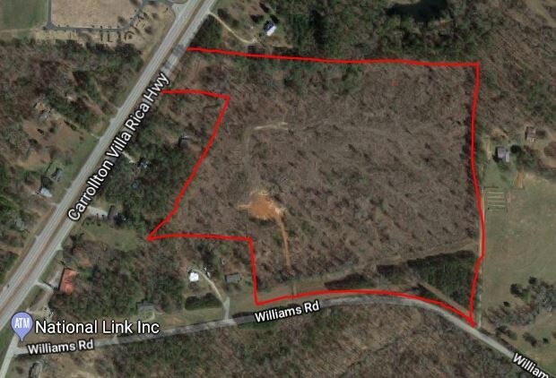
Property Detail
Williams Rd
M01-0010034
V/38AC WILLIAMS RD CO37 & MZ11A
Agriculturalland
CARROLL
AG
Georgia
B and X Area of moderate flood hazard, usually the area between the limits of the 100-year and 500-year floods.
38 AC
2025
Villa Rica/West Outlying
2025
Atlanta
910302
Atlanta-Sandy Springs-Roswell, GA
NEARBY LISTINGS FOR SALE OR LEASE
-
-
-
-
No Photo
-
-
View all Waco listings for sale on LoopNet.com
DEMOGRAPHICS near Williams Rd
1 mile
3 mile
5 mile
2025 Total Population
1,003
12,687
27,438
2030 Population
1,088
13,709
29,635
Pop Growth 2025-2030
+ 8.47%
+ 8.06%
+ 8.01%
Average Age
41
41
39
2025 Total Households
379
4,639
9,809
HH Growth 2025-2030
+ 8.71%
+ 8.13%
+ 8.07%
Median Household Inc
$88,157
$95,162
$89,651
Avg Household Size
2.60
2.70
2.70
2025 Avg HH Vehicles
2.00
2.00
2.00
Median Home Value
$282,672
$292,501
$288,934
Median Year Built
1992
1993
1995
Nearby Places
Map Layers
Map Styles
 Street
 Aerial
Layers
 Traffic
 Biking
Places
Listings with unknown addresses are not visible on the map
- Restaurants
- Banks
- Shops
- Fitness
- Groceries
SALE & LEASE HISTORY
LISTING DATE
SALE/LEASE

Jul 10, 2018
For Sale
Nearby Properties
Address
Land Use
TOTAL SIZE
Lot Size
Zoning
Address
Land Use
TOTAL SIZE
Lot Size
Zoning
3,910 SF
19.13 AC
WAC
Address
Land Use
TOTAL SIZE
Lot Size
Zoning
36,250 SF
72.32 AC
WAC
Address
Land Use
TOTAL SIZE
Lot Size
Zoning
28,186 SF
8 AC
C
Address
Land Use
TOTAL SIZE
Lot Size
Zoning
8,130 SF
1.21 AC
C
Address
Land Use
TOTAL SIZE
Lot Size
Zoning
9,315 SF
25.99 AC
WAC
Address
Land Use
TOTAL SIZE
Lot Size
Zoning
9,804 SF
3.84 AC
C
Address
Land Use
TOTAL SIZE
Lot Size
Zoning
7,072 SF
36.89 AC
COMM
Address
Land Use
TOTAL SIZE
Lot Size
Zoning
4.56 AC
002
Address
Land Use
TOTAL SIZE
Lot Size
Zoning
4,880 SF
1.24 AC
WAC
Address
Land Use
TOTAL SIZE
Lot Size
Zoning
13,278 SF
1.86 AC
C
Address
Land Use
TOTAL SIZE
Lot Size
Zoning
10,182 SF
5 AC
WAC
Address
Land Use
TOTAL SIZE
Lot Size
Zoning
6,000 SF
15.19 AC
WAC
Address
Land Use
TOTAL SIZE
Lot Size
Zoning
9,230 SF
19.08 AC
A
Address
Land Use
TOTAL SIZE
Lot Size
Zoning
10,560 SF
5 AC
A-1
Address
Land Use
TOTAL SIZE
Lot Size
Zoning
3,131 SF
1.20 AC
C2
Address
Land Use
TOTAL SIZE
Lot Size
Zoning
286.25 AC
AG
Address
Land Use
TOTAL SIZE
Lot Size
Zoning
4,036 SF
1.03 AC
C2
Address
Land Use
TOTAL SIZE
Lot Size
Zoning
248.28 AC
I-1
Address
Land Use
TOTAL SIZE
Lot Size
Zoning
61.70 AC
WAC
Address
Land Use
TOTAL SIZE
Lot Size
Zoning
2,828 SF
1.16 AC
C
Address
Land Use
TOTAL SIZE
Lot Size
Zoning
46.68 AC
BRE C-2
Address
Land Use
TOTAL SIZE
Lot Size
Zoning
442.67 AC
M1
Address
Land Use
TOTAL SIZE
Lot Size
Zoning
4,200 SF
5.24 AC
WAC
Address
Land Use
TOTAL SIZE
Lot Size
Zoning
404.75 AC
A-1
Address
Land Use
TOTAL SIZE
Lot Size
Zoning
5,886 SF
3.99 AC
WAC
Address
Land Use
TOTAL SIZE
Lot Size
Zoning
9,000 SF
2.79 AC
C
Address
Land Use
TOTAL SIZE
Lot Size
Zoning
75.44 AC
WAC
Address
Land Use
TOTAL SIZE
Lot Size
Zoning
3,584 SF
2.02 AC
C
Address
Land Use
TOTAL SIZE
Lot Size
Zoning
41.68 AC
BRE
Address
Land Use
TOTAL SIZE
Lot Size
Zoning
9,100 SF
1.86 AC
COMM
The World's #1 Commercial Real Estate Marketplace
Connect with us
© 2026 CoStar Group
The information above has been obtained from sources believed reliable. While we do not doubt its accuracy we have not verified it and make no guarantee, warranty or representation about it. It is your responsibility to independently confirm its accuracy and completeness. Any projections, opinions, assumptions, or estimates used are for example only and do not represent the current or future performance of the property. The value of this transaction to you depends on tax and other factors which should be evaluated by your tax, financial, and legal advisors. You and your advisors should conduct a careful, independent investigation of the property to determine to your satisfaction the suitability of the property for your needs.