Property Record
Willis Ln, , MD

Property Detail
Willis Ln
20-400145
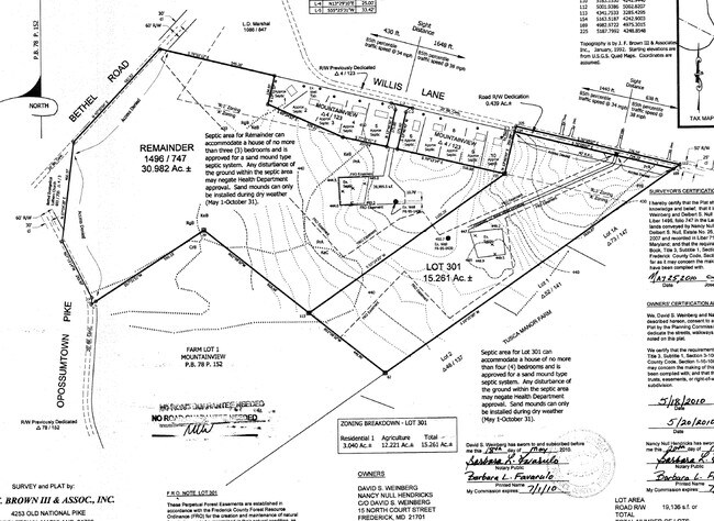
30.98 AC E/S BETHEL RD. S. OF WILLIS LANE
Agriculturalland
FREDERICK
A
Maryland
B and X Area of moderate flood hazard, usually the area between the limits of the 100-year and 500-year floods.
30.98 AC
2024
Frederick
2025
Washington, DC
751302
Washington-Arlington-Alexandria, DC-VA-MD-WV
3,007 SF
NEARBY LISTINGS FOR SALE OR LEASE
-
-
View all listings for sale on LoopNet.com
DEMOGRAPHICS near Willis Ln
1 mile
3 mile
5 mile
2024 Total Population
794
13,824
53,087
2029 Population
854
15,109
57,787
Pop Growth 2024-2029
+ 7.56%
+ 9.30%
+ 8.85%
Average Age
45
44
42
2024 Total Households
308
5,054
19,936
HH Growth 2024-2029
+ 7.79%
+ 9.56%
+ 9.01%
Median Household Inc
$107,954
$132,716
$115,976
Avg Household Size
2.50
2.60
2.60
2024 Avg HH Vehicles
3.00
2.00
2.00
Median Home Value
$453,749
$489,167
$435,965
Median Year Built
1975
1995
1994
Nearby Places
Map Layers
Map Styles
 Street
 Aerial
Transit
 Traffic
 Biking
Places
Listings with unknown addresses are not visible on the map
- Restaurants
- Banks
- Shops
- Fitness
- Groceries
PUBLIC TRANSPORTATION
COMMUTER RAIL
Frederick Marc Wb (BRUNSWICK - WASHINGTON - Maryland Transit Administration)
Drive
Walk
Distance
Frederick Marc Wb (BRUNSWICK - WASHINGTON - Maryland Transit Administration)
19 min
8.8 mi
AIRPORT
Hagerstown Regional/Richard A Henson Field
Drive
Walk
Distance
Hagerstown Regional/Richard A Henson Field
53 min
33.8 mi
Freight Ports
Port of Baltimore
Drive
Walk
Distance
Port of Baltimore
77 min
58.7 mi
SALE & LEASE HISTORY
LISTING DATE
SALE/LEASE

Sep 24, 2016
For Sale
Nearby Properties
Address
Land Use
TOTAL SIZE
Lot Size
Zoning
Address
Land Use
TOTAL SIZE
Lot Size
Zoning
259,468 SF
95.75 AC
IST
Address
Land Use
TOTAL SIZE
Lot Size
Zoning
150,793 SF
27.13 AC
IST
Address
Land Use
TOTAL SIZE
Lot Size
Zoning
90,000 SF
25.69 AC
R2
Address
Land Use
TOTAL SIZE
Lot Size
Zoning
119,192 SF
36.37 AC
IST
Address
Land Use
TOTAL SIZE
Lot Size
Zoning
69,417 SF
138.85 AC
A
Address
Land Use
TOTAL SIZE
Lot Size
Zoning
34,490 SF
4.99 AC
R1
Address
Land Use
TOTAL SIZE
Lot Size
Zoning
5,968 SF
252.01 AC
A
Address
Land Use
TOTAL SIZE
Lot Size
Zoning
32,417 SF
10.46 AC
GC
Address
Land Use
TOTAL SIZE
Lot Size
Zoning
20,736 SF
33.88 AC
A
Address
Land Use
TOTAL SIZE
Lot Size
Zoning
8,000 SF
3.97 AC
GC
Address
Land Use
TOTAL SIZE
Lot Size
Zoning
27,078 SF
9 AC
A
Address
Land Use
TOTAL SIZE
Lot Size
Zoning
18,947 SF
15.23 AC
R1
Address
Land Use
TOTAL SIZE
Lot Size
Zoning
45.96 AC
Address
Land Use
TOTAL SIZE
Lot Size
Zoning
8,412 SF
25.01 AC
A
Address
Land Use
TOTAL SIZE
Lot Size
Zoning
16,646 SF
39.30 AC
A
Address
Land Use
TOTAL SIZE
Lot Size
Zoning
4,496 SF
111.54 AC
AC
Address
Land Use
TOTAL SIZE
Lot Size
Zoning
8,605 SF
2.39 AC
GC
Address
Land Use
TOTAL SIZE
Lot Size
Zoning
8,107 SF
76.49 AC
A
Address
Land Use
TOTAL SIZE
Lot Size
Zoning
8,916 SF
2.53 AC
GC
Address
Land Use
TOTAL SIZE
Lot Size
Zoning
6,123 SF
25 AC
Address
Land Use
TOTAL SIZE
Lot Size
Zoning
13,110 SF
3.90 AC
GC
Address
Land Use
TOTAL SIZE
Lot Size
Zoning
7,458 SF
30.35 AC
A
Address
Land Use
TOTAL SIZE
Lot Size
Zoning
4,176 SF
29.55 AC
R1
Address
Land Use
TOTAL SIZE
Lot Size
Zoning
3,800 SF
2.60 AC
GC
Address
Land Use
TOTAL SIZE
Lot Size
Zoning
6,342 SF
15.82 AC
A
Address
Land Use
TOTAL SIZE
Lot Size
Zoning
6,940 SF
4.08 AC
R1
Address
Land Use
TOTAL SIZE
Lot Size
Zoning
18,604 SF
3.93 AC
GC
Address
Land Use
TOTAL SIZE
Lot Size
Zoning
24.20 AC
Address
Land Use
TOTAL SIZE
Lot Size
Zoning
12,000 SF
2.61 AC
GC
Address
Land Use
TOTAL SIZE
Lot Size
Zoning
5,691 SF
15.42 AC
The World's #1 Commercial Real Estate Marketplace
Connect with us
© 2026 CoStar Group
The information above has been obtained from sources believed reliable. While we do not doubt its accuracy we have not verified it and make no guarantee, warranty or representation about it. It is your responsibility to independently confirm its accuracy and completeness. Any projections, opinions, assumptions, or estimates used are for example only and do not represent the current or future performance of the property. The value of this transaction to you depends on tax and other factors which should be evaluated by your tax, financial, and legal advisors. You and your advisors should conduct a careful, independent investigation of the property to determine to your satisfaction the suitability of the property for your needs.