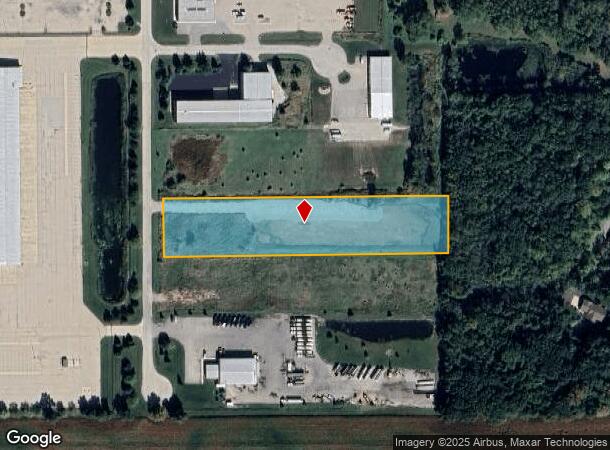
Property Record
Winncrest Rd, Neenah, WI 54956
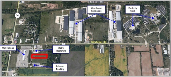

NEARBY LISTINGS FOR SALE OR LEASE
Property Detail
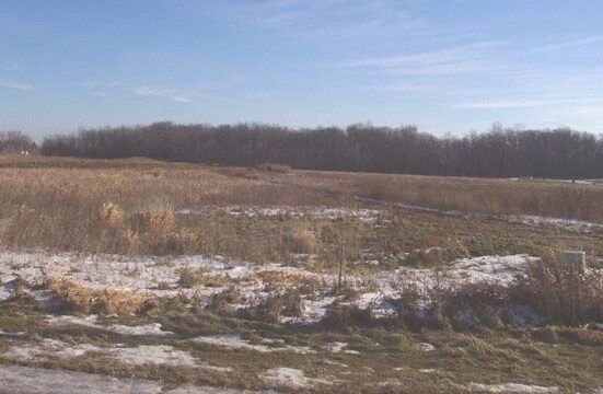
Winncrest Rd
Oshkosh-Neenah, WI
Certified Survey Map No 5579
006-062005
PT N1/2 NW1/4 DESC AS LOT 1 OF CSM-5579 3.00 A.
Commercialnec
Winnebago
X
Wisconsin
55087C0425D
1
2024
3 AC
2024
Appleton/Oshkosh
003400
Other Market Areas
DEMOGRAPHICS near Winncrest Rd
1 mile
3 mile
5 mile
2024 Total Population
585
14,035
52,926
2029 Population
589
14,041
52,946
Pop Growth 2024-2029
+ 0.68%
+ 0.04%
+ 0.04%
Average Age
41
40
40
2024 Total Households
214
5,619
22,093
HH Growth 2024-2029
+ 0.47%
(0.12%)
(0.10%)
Median Household Inc
$99,166
$83,124
$70,153
Avg Household Size
2.70
2.50
2.30
2024 Avg HH Vehicles
3.00
2.00
2.00
Median Home Value
$337,705
$247,742
$194,758
Median Year Built
1984
1983
1974
Nearby Places
Map Layers
Map Styles
 Street
 Aerial
Transit
 Traffic
 Biking
Places
Listings with unknown addresses are not visible on the map
- Restaurants
- Banks
- Shops
- Fitness
- Groceries
PUBLIC TRANSPORTATION
AIRPORT
Appleton International
Drive
Walk
Distance
Appleton International
11 min
5.3 mi
Green Bay/Austin Straubel International
Drive
Walk
Distance
Green Bay/Austin Straubel International
48 min
37.6 mi
Freight Ports
Port Milwaukee
Drive
Walk
Distance
Port Milwaukee
123 min
101.2 mi
SALE & LEASE HISTORY
LISTING DATE
SALE/LEASE

Sep 24, 2016
For Sale
Mar 12, 2018
For Sale
Jan 07, 2019
For Sale
Apr 11, 2017
For Sale
Nearby Properties
Address
Land Use
TOTAL SIZE
Lot Size
Zoning
Address
Land Use
TOTAL SIZE
Lot Size
Zoning
156.36 AC
M1
Address
Land Use
TOTAL SIZE
Lot Size
Zoning
11.99 AC
Address
Land Use
TOTAL SIZE
Lot Size
Zoning
120.73 AC
M2
Address
Land Use
TOTAL SIZE
Lot Size
Zoning
11.22 AC
Address
Land Use
TOTAL SIZE
Lot Size
Zoning
1,975 SF
2.40 AC
M2
Address
Land Use
TOTAL SIZE
Lot Size
Zoning
9.40 AC
Address
Land Use
TOTAL SIZE
Lot Size
Zoning
6.75 AC
M1
Address
Land Use
TOTAL SIZE
Lot Size
Zoning
10.42 AC
Address
Land Use
TOTAL SIZE
Lot Size
Zoning
32.54 AC
Address
Land Use
TOTAL SIZE
Lot Size
Zoning
15.73 AC
B5
Address
Land Use
TOTAL SIZE
Lot Size
Zoning
210,214 SF
16.44 AC
I1
Address
Land Use
TOTAL SIZE
Lot Size
Zoning
17.55 AC
A2
Address
Land Use
TOTAL SIZE
Lot Size
Zoning
4.33 AC
Address
Land Use
TOTAL SIZE
Lot Size
Zoning
74,603 SF
4.96 AC
I1
Address
Land Use
TOTAL SIZE
Lot Size
Zoning
7.29 AC
Address
Land Use
TOTAL SIZE
Lot Size
Zoning
92,030 SF
7.79 AC
I1
Address
Land Use
TOTAL SIZE
Lot Size
Zoning
11.77 AC
R5
Address
Land Use
TOTAL SIZE
Lot Size
Zoning
32.60 AC
Address
Land Use
TOTAL SIZE
Lot Size
Zoning
48,933 SF
2.80 AC
PDD
Address
Land Use
TOTAL SIZE
Lot Size
Zoning
4.71 AC
Address
Land Use
TOTAL SIZE
Lot Size
Zoning
4.41 AC
B5
Address
Land Use
TOTAL SIZE
Lot Size
Zoning
28.64 AC
Address
Land Use
TOTAL SIZE
Lot Size
Zoning
39.59 AC
M2
Address
Land Use
TOTAL SIZE
Lot Size
Zoning
37,672 SF
5.26 AC
PDD
Address
Land Use
TOTAL SIZE
Lot Size
Zoning
117,640 SF
7.45 AC
I1
Address
Land Use
TOTAL SIZE
Lot Size
Zoning
13.84 AC
M1
Address
Land Use
TOTAL SIZE
Lot Size
Zoning
21.64 AC
B5
Address
Land Use
TOTAL SIZE
Lot Size
Zoning
50,652 SF
8.51 AC
C1
Address
Land Use
TOTAL SIZE
Lot Size
Zoning
1.62 AC
B5
Address
Land Use
TOTAL SIZE
Lot Size
Zoning
14.65 AC
M2
The World's #1 Commercial Real Estate Marketplace
Connect with us
© 2026 CoStar Group
The information above has been obtained from sources believed reliable. While we do not doubt its accuracy we have not verified it and make no guarantee, warranty or representation about it. It is your responsibility to independently confirm its accuracy and completeness. Any projections, opinions, assumptions, or estimates used are for example only and do not represent the current or future performance of the property. The value of this transaction to you depends on tax and other factors which should be evaluated by your tax, financial, and legal advisors. You and your advisors should conduct a careful, independent investigation of the property to determine to your satisfaction the suitability of the property for your needs.