Property Record
Winton Rd, Cincinnati, OH 45231
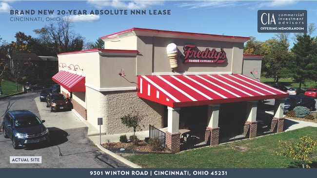
This Property Is For Sale
Property Detail
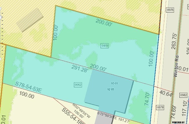
Winton Rd
590-0180-1048
WS WINTON RD 0.1342 AC R1-T3-S15 SW
Commercialacreage
HAMILTON
B2
Ohio
B and X Area of moderate flood hazard, usually the area between the limits of the 100-year and 500-year floods.
0.13 AC
2025
Forest Park/West
2025
Cincinnati/Dayton
021702
Cincinnati, OH-KY-IN
NEARBY LISTINGS FOR SALE OR LEASE
DEMOGRAPHICS near Winton Rd
1 mile
3 mile
5 mile
2025 Total Population
7,920
77,441
221,678
2030 Population
7,894
77,936
223,590
Pop Growth 2025-2030
(0.33%)
+ 0.64%
+ 0.86%
Average Age
43
41
40
2025 Total Households
3,051
31,490
90,820
HH Growth 2025-2030
(0.36%)
+ 0.63%
+ 0.88%
Median Household Inc
$102,300
$69,424
$60,987
Avg Household Size
2.50
2.40
2.30
2025 Avg HH Vehicles
2.00
2.00
2.00
Median Home Value
$249,569
$194,672
$184,641
Median Year Built
1959
1958
1961
Nearby Places
Map Layers
Map Styles
 Street
 Aerial
Transit
 Traffic
 Biking
Places
Listings with unknown addresses are not visible on the map
- Restaurants
- Banks
- Shops
- Fitness
- Groceries
PUBLIC TRANSPORTATION
AIRPORT
Cincinnati/Northern Kentucky International
Drive
Walk
Distance
Cincinnati/Northern Kentucky International
46 min
25.2 mi
Freight Ports
Port of Toledo
Drive
Walk
Distance
Port of Toledo
235 min
197.7 mi
Nearby Properties
Address
Land Use
TOTAL SIZE
Lot Size
Zoning
Address
Land Use
TOTAL SIZE
Lot Size
Zoning
87,612 SF
16.29 AC
R3
Address
Land Use
TOTAL SIZE
Lot Size
Zoning
Address
Land Use
TOTAL SIZE
Lot Size
Zoning
11,639 SF
7.87 AC
R2
Address
Land Use
TOTAL SIZE
Lot Size
Zoning
24.69 AC
Address
Land Use
TOTAL SIZE
Lot Size
Zoning
25,098 SF
21.31 AC
Address
Land Use
TOTAL SIZE
Lot Size
Zoning
42.41 AC
Address
Land Use
TOTAL SIZE
Lot Size
Zoning
344,923 SF
18.47 AC
RM20
Address
Land Use
TOTAL SIZE
Lot Size
Zoning
13.08 AC
Address
Land Use
TOTAL SIZE
Lot Size
Zoning
5,085 SF
15.17 AC
Address
Land Use
TOTAL SIZE
Lot Size
Zoning
20.07 AC
B2
Address
Land Use
TOTAL SIZE
Lot Size
Zoning
2.22 AC
Address
Land Use
TOTAL SIZE
Lot Size
Zoning
6,652 SF
15.45 AC
R1
Address
Land Use
TOTAL SIZE
Lot Size
Zoning
88.15 AC
ML
Address
Land Use
TOTAL SIZE
Lot Size
Zoning
103.18 AC
R1A
Address
Land Use
TOTAL SIZE
Lot Size
Zoning
8,720 SF
33.28 AC
R3
Address
Land Use
TOTAL SIZE
Lot Size
Zoning
60,614 SF
13.35 AC
SF6
Address
Land Use
TOTAL SIZE
Lot Size
Zoning
Address
Land Use
TOTAL SIZE
Lot Size
Zoning
4,800 SF
7.20 AC
Address
Land Use
TOTAL SIZE
Lot Size
Zoning
2,400 SF
0.35 AC
R1
Address
Land Use
TOTAL SIZE
Lot Size
Zoning
121,747 SF
23.05 AC
R3
Address
Land Use
TOTAL SIZE
Lot Size
Zoning
Address
Land Use
TOTAL SIZE
Lot Size
Zoning
28.25 AC
Address
Land Use
TOTAL SIZE
Lot Size
Zoning
Address
Land Use
TOTAL SIZE
Lot Size
Zoning
Address
Land Use
TOTAL SIZE
Lot Size
Zoning
65.26 AC
R3
Address
Land Use
TOTAL SIZE
Lot Size
Zoning
8,576 SF
5.88 AC
RPUD
Address
Land Use
TOTAL SIZE
Lot Size
Zoning
11,484 SF
16.56 AC
Address
Land Use
TOTAL SIZE
Lot Size
Zoning
Address
Land Use
TOTAL SIZE
Lot Size
Zoning
86.98 AC
R1
Address
Land Use
TOTAL SIZE
Lot Size
Zoning
54,510 SF
4.99 AC
CCA
The World's #1 Commercial Real Estate Marketplace
Connect with us
© 2026 CoStar Group
The information above has been obtained from sources believed reliable. While we do not doubt its accuracy we have not verified it and make no guarantee, warranty or representation about it. It is your responsibility to independently confirm its accuracy and completeness. Any projections, opinions, assumptions, or estimates used are for example only and do not represent the current or future performance of the property. The value of this transaction to you depends on tax and other factors which should be evaluated by your tax, financial, and legal advisors. You and your advisors should conduct a careful, independent investigation of the property to determine to your satisfaction the suitability of the property for your needs.