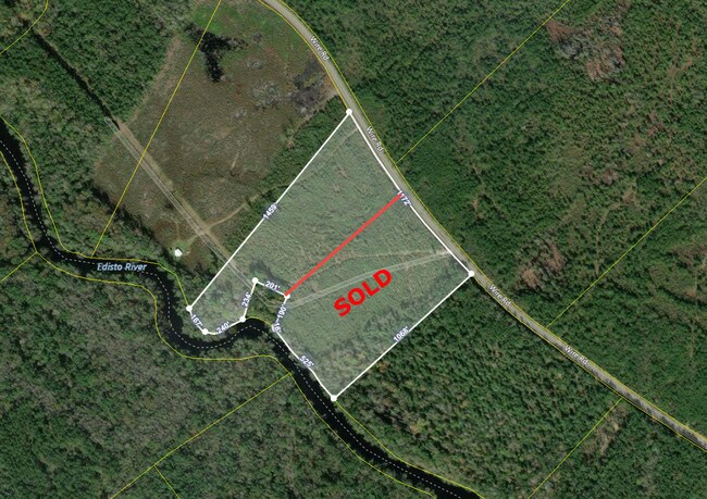
Property Record
Wire Rd, Branchville, SC 29432

Property Detail
Wire Rd
054-00-00-053
WIRE RD VACANT LAND
Vacantlandnec
DORCHESTER
AR_DC
South Carolina
AE The base floodplain where base flood elevations are provided. AE Zones are now used on new format FIRMs instead of A1-A30 Zones.
12.43 AC
2025
Dorchester County
2025
Charleston/N Charleston
011701
Charleston-North Charleston, SC
NEARBY LISTINGS FOR SALE OR LEASE
-
-
View all Branchville listings for sale on LoopNet.com
DEMOGRAPHICS near Wire Rd
1 mile
3 mile
5 mile
2025 Total Population
42
482
1,770
2030 Population
46
524
1,887
Pop Growth 2025-2030
+ 9.52%
+ 8.71%
+ 6.61%
Average Age
44
43
44
2025 Total Households
18
203
734
HH Growth 2025-2030
+ 11.11%
+ 8.87%
+ 6.81%
Median Household Inc
$39,999
$42,222
$43,408
Avg Household Size
2.30
2.40
2.40
2025 Avg HH Vehicles
2.00
2.00
2.00
Median Home Value
$250,000
$208,333
$186,600
Median Year Built
1989
1988
1988
Nearby Places
Map Layers
Map Styles
 Street
 Aerial
Layers
 Traffic
 Biking
Places
Listings with unknown addresses are not visible on the map
- Restaurants
- Banks
- Shops
- Fitness
- Groceries
SALE & LEASE HISTORY
LISTING DATE
SALE/LEASE

May 23, 2019
For Sale
Nearby Properties
Address
Land Use
TOTAL SIZE
Lot Size
Zoning
Address
Land Use
TOTAL SIZE
Lot Size
Zoning
249 AC
RD
Address
Land Use
TOTAL SIZE
Lot Size
Zoning
Address
Land Use
TOTAL SIZE
Lot Size
Zoning
335.21 AC
AR_DC
Address
Land Use
TOTAL SIZE
Lot Size
Zoning
491 AC
RD
Address
Land Use
TOTAL SIZE
Lot Size
Zoning
254.35 AC
AR_DC
Address
Land Use
TOTAL SIZE
Lot Size
Zoning
311.40 AC
RD
Address
Land Use
TOTAL SIZE
Lot Size
Zoning
200 AC
AR_DC
Address
Land Use
TOTAL SIZE
Lot Size
Zoning
191.55 AC
AR_DC
Address
Land Use
TOTAL SIZE
Lot Size
Zoning
255 AC
RD
Address
Land Use
TOTAL SIZE
Lot Size
Zoning
164 AC
AR_DC
Address
Land Use
TOTAL SIZE
Lot Size
Zoning
2 AC
RD
Address
Land Use
TOTAL SIZE
Lot Size
Zoning
93.89 AC
AR_DC
Address
Land Use
TOTAL SIZE
Lot Size
Zoning
148.98 AC
AR_DC
Address
Land Use
TOTAL SIZE
Lot Size
Zoning
139 AC
AR_DC
Address
Land Use
TOTAL SIZE
Lot Size
Zoning
137.53 AC
AR_DC
Address
Land Use
TOTAL SIZE
Lot Size
Zoning
98.43 AC
AR_DC
Address
Land Use
TOTAL SIZE
Lot Size
Zoning
97.41 AC
AR_DC
Address
Land Use
TOTAL SIZE
Lot Size
Zoning
97.42 AC
AR_DC
Address
Land Use
TOTAL SIZE
Lot Size
Zoning
97.41 AC
AR_DC
Address
Land Use
TOTAL SIZE
Lot Size
Zoning
97.42 AC
AR_DC
Address
Land Use
TOTAL SIZE
Lot Size
Zoning
135.42 AC
AR_DC
Address
Land Use
TOTAL SIZE
Lot Size
Zoning
132.67 AC
AR_DC
Address
Land Use
TOTAL SIZE
Lot Size
Zoning
130.83 AC
AR_DC
Address
Land Use
TOTAL SIZE
Lot Size
Zoning
130.46 AC
AR_DC
Address
Land Use
TOTAL SIZE
Lot Size
Zoning
88.31 AC
AR_DC
Address
Land Use
TOTAL SIZE
Lot Size
Zoning
90.04 AC
AR_DC
Address
Land Use
TOTAL SIZE
Lot Size
Zoning
123.80 AC
AR_DC
Address
Land Use
TOTAL SIZE
Lot Size
Zoning
87.77 AC
AR_DC
Address
Land Use
TOTAL SIZE
Lot Size
Zoning
85.65 AC
AR_DC
Address
Land Use
TOTAL SIZE
Lot Size
Zoning
198 AC
RD
The World's #1 Commercial Real Estate Marketplace
Connect with us
© 2026 CoStar Group
The information above has been obtained from sources believed reliable. While we do not doubt its accuracy we have not verified it and make no guarantee, warranty or representation about it. It is your responsibility to independently confirm its accuracy and completeness. Any projections, opinions, assumptions, or estimates used are for example only and do not represent the current or future performance of the property. The value of this transaction to you depends on tax and other factors which should be evaluated by your tax, financial, and legal advisors. You and your advisors should conduct a careful, independent investigation of the property to determine to your satisfaction the suitability of the property for your needs.