Property Record
Wire Rd, , SC
Property Detail
Wire Rd
Charleston-North Charleston, SC
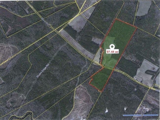
Plat Showing A Boundary Survey Of Tms 04
040-00-00-003
WIRE RD VACANT LAND
Vacantlandnec
Dorchester
AE
South Carolina
45029C0045G
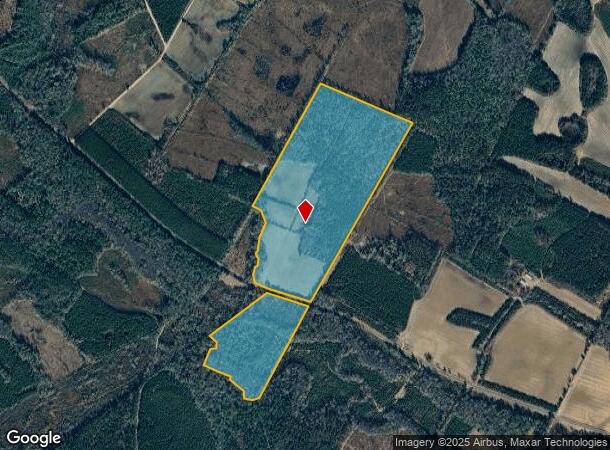
97.54 AC
2025
Dorchester County
2025
Charleston/N Charleston
NEARBY LISTINGS FOR SALE OR LEASE
-
-
View all listings for sale on LoopNet.com
DEMOGRAPHICS near Wire Rd
1 mile
3 mile
5 mile
2024 Total Population
2
300
1,221
2029 Population
2
305
1,234
Pop Growth 2024-2029
0.00%
+ 1.67%
+ 1.06%
Average Age
0
43
43
2024 Total Households
1
122
493
HH Growth 2024-2029
0.00%
+ 1.64%
+ 1.22%
Median Household Inc
$0
$34,545
$36,614
Avg Household Size
.00
2.40
2.40
2024 Avg HH Vehicles
1.00
2.00
2.00
Median Home Value
$0
$102,000
$92,646
Median Year Built
0
1987
1989
Nearby Places
Map Layers
Map Styles
 Street
 Aerial
Transit
 Traffic
 Biking
Places
Listings with unknown addresses are not visible on the map
- Restaurants
- Banks
- Shops
- Fitness
- Groceries
SALE & LEASE HISTORY
LISTING DATE
SALE/LEASE

Sep 21, 2017
For Sale
Nearby Properties
Address
Land Use
TOTAL SIZE
Lot Size
Zoning
Address
Land Use
TOTAL SIZE
Lot Size
Zoning
7,547 SF
18.80 AC
RD
Address
Land Use
TOTAL SIZE
Lot Size
Zoning
335.21 AC
AR_DC
Address
Land Use
TOTAL SIZE
Lot Size
Zoning
491 AC
RD
Address
Land Use
TOTAL SIZE
Lot Size
Zoning
254.35 AC
AR_DC
Address
Land Use
TOTAL SIZE
Lot Size
Zoning
1,049 SF
259 AC
RD
Address
Land Use
TOTAL SIZE
Lot Size
Zoning
200 AC
AR_DC
Address
Land Use
TOTAL SIZE
Lot Size
Zoning
Address
Land Use
TOTAL SIZE
Lot Size
Zoning
191.55 AC
AR_DC
Address
Land Use
TOTAL SIZE
Lot Size
Zoning
239 AC
RD
Address
Land Use
TOTAL SIZE
Lot Size
Zoning
164 AC
AR_DC
Address
Land Use
TOTAL SIZE
Lot Size
Zoning
162.10 AC
AR_DC
Address
Land Use
TOTAL SIZE
Lot Size
Zoning
148.98 AC
AR_DC
Address
Land Use
TOTAL SIZE
Lot Size
Zoning
206 AC
RD
Address
Land Use
TOTAL SIZE
Lot Size
Zoning
139 AC
AR_DC
Address
Land Use
TOTAL SIZE
Lot Size
Zoning
137.53 AC
AR_DC
Address
Land Use
TOTAL SIZE
Lot Size
Zoning
97.41 AC
AR_DC
Address
Land Use
TOTAL SIZE
Lot Size
Zoning
97.42 AC
AR_DC
Address
Land Use
TOTAL SIZE
Lot Size
Zoning
132.67 AC
AR_DC
Address
Land Use
TOTAL SIZE
Lot Size
Zoning
130.83 AC
AR_DC
Address
Land Use
TOTAL SIZE
Lot Size
Zoning
130.46 AC
AR_DC
Address
Land Use
TOTAL SIZE
Lot Size
Zoning
88.31 AC
AR_DC
Address
Land Use
TOTAL SIZE
Lot Size
Zoning
87.77 AC
AR_DC
Address
Land Use
TOTAL SIZE
Lot Size
Zoning
198 AC
RD
Address
Land Use
TOTAL SIZE
Lot Size
Zoning
97.41 AC
AR_DC
Address
Land Use
TOTAL SIZE
Lot Size
Zoning
100.50 AC
AR_DC
Address
Land Use
TOTAL SIZE
Lot Size
Zoning
71.90 AC
AR_DC
Address
Land Use
TOTAL SIZE
Lot Size
Zoning
71.22 AC
AR_DC
Address
Land Use
TOTAL SIZE
Lot Size
Zoning
99 AC
AR_DC
Address
Land Use
TOTAL SIZE
Lot Size
Zoning
70.42 AC
AR_DC
The World's #1 Commercial Real Estate Marketplace
Connect with us
© 2026 CoStar Group
The information above has been obtained from sources believed reliable. While we do not doubt its accuracy we have not verified it and make no guarantee, warranty or representation about it. It is your responsibility to independently confirm its accuracy and completeness. Any projections, opinions, assumptions, or estimates used are for example only and do not represent the current or future performance of the property. The value of this transaction to you depends on tax and other factors which should be evaluated by your tax, financial, and legal advisors. You and your advisors should conduct a careful, independent investigation of the property to determine to your satisfaction the suitability of the property for your needs.