Property Record
Witmer Dr, Hummelstown, PA 17036
NEARBY LISTINGS FOR SALE OR LEASE
-
-
View all Hummelstown listings for lease on LoopNet.com
Property Detail
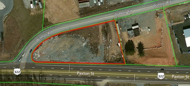
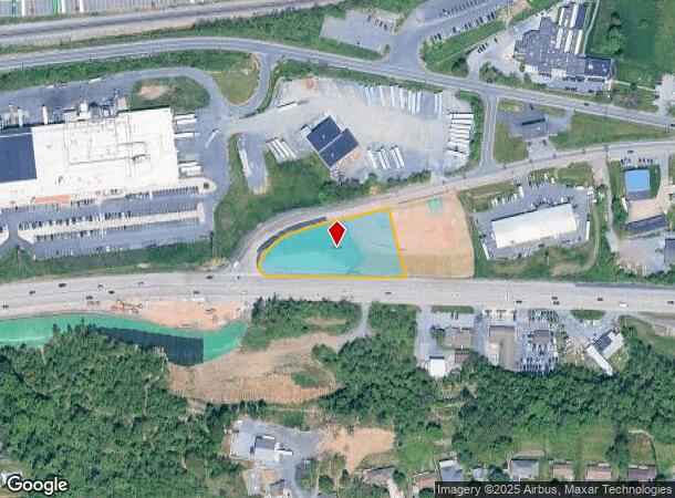
Witmer Dr
63-023-001
Dauphin
Commercialacreage
Pennsylvania
X
0.79 AC
42043C0345D
Harrisburg Area East
0
Philadelphia
2025
Harrisburg-Carlisle, PA
024503
DEMOGRAPHICS near Witmer Dr
1 Mile
3 Mile
5 Mile
2024 Total Population
6,332
41,809
132,921
2029 Population
6,437
42,494
135,284
Pop Growth 2024-2029
+ 1.66%
+ 1.64%
+ 1.78%
Average Age
38
40
40
2024 Total Households
2,511
16,783
53,561
HH Growth 2024-2029
+ 1.79%
+ 1.76%
+ 1.86%
Median Household Inc
$87,345
$82,909
$70,577
Avg Household Size
2.50
2.50
2.40
2024 Avg HH Vehicles
2.00
2.00
2.00
Median Home Value
$175,883
$228,428
$195,344
Median Year Built
1985
1983
1973
Nearby Places
Map Layers
Map Styles
 Street
 Aerial
- Restaurants
- Banks
- Shops
- Fitness
- Groceries
PUBLIC TRANSPORTATION
COMMUTER RAIL
Harrisburg (Keystone Service - Amtrak, Pennsylvanian - Amtrak)
DRIVE
WALK
Distance
Harrisburg (Keystone Service - Amtrak, Pennsylvanian - Amtrak)
10 min
7.1 mi
Middletown (Keystone Service - Amtrak)
DRIVE
WALK
Distance
Middletown (Keystone Service - Amtrak)
16 min
8.1 mi
AIRPORT
Harrisburg International
DRIVE
WALK
Distance
Harrisburg International
15 min
10.0 mi
Freight Ports
Port of Baltimore
DRIVE
WALK
Distance
Port of Baltimore
115 min
86.2 mi
SALE & LEASE HISTORY
LISTING DATE
SALE/LEASE

Jul 11, 2017
For Lease
Jul 11, 2017
For Sale
Aug 02, 2017
For Lease
Aug 01, 2017
For Lease
Nearby Properties
Address
Land Use
TOTAL SIZE
Lot Size
Zoning
Address
Land Use
TOTAL SIZE
Lot Size
Zoning
74,032 SF
74.81 AC
Address
Land Use
TOTAL SIZE
Lot Size
Zoning
4,176 SF
192.96 AC
Address
Land Use
TOTAL SIZE
Lot Size
Zoning
Address
Land Use
TOTAL SIZE
Lot Size
Zoning
172,289 SF
86.54 AC
Address
Land Use
TOTAL SIZE
Lot Size
Zoning
142,010 SF
53.46 AC
Address
Land Use
TOTAL SIZE
Lot Size
Zoning
50,963 SF
46.61 AC
Address
Land Use
TOTAL SIZE
Lot Size
Zoning
211,430 SF
38.50 AC
Address
Land Use
TOTAL SIZE
Lot Size
Zoning
651,250 SF
47.13 AC
Address
Land Use
TOTAL SIZE
Lot Size
Zoning
247,216 SF
46.91 AC
Address
Land Use
TOTAL SIZE
Lot Size
Zoning
1,196 SF
50.34 AC
Address
Land Use
TOTAL SIZE
Lot Size
Zoning
3,232 SF
38.86 AC
Address
Land Use
TOTAL SIZE
Lot Size
Zoning
507,000 SF
32.82 AC
Address
Land Use
TOTAL SIZE
Lot Size
Zoning
13,348 SF
25.38 AC
Address
Land Use
TOTAL SIZE
Lot Size
Zoning
167,713 SF
11.50 AC
Address
Land Use
TOTAL SIZE
Lot Size
Zoning
348,615 SF
38.98 AC
Address
Land Use
TOTAL SIZE
Lot Size
Zoning
1,254 SF
25.34 AC
Address
Land Use
TOTAL SIZE
Lot Size
Zoning
18.43 AC
Address
Land Use
TOTAL SIZE
Lot Size
Zoning
196,000 SF
12.42 AC
Address
Land Use
TOTAL SIZE
Lot Size
Zoning
249,112 SF
24.01 AC
Address
Land Use
TOTAL SIZE
Lot Size
Zoning
107,853 SF
12 AC
Address
Land Use
TOTAL SIZE
Lot Size
Zoning
300,000 SF
17.71 AC
Address
Land Use
TOTAL SIZE
Lot Size
Zoning
132,588 SF
18.49 AC
Address
Land Use
TOTAL SIZE
Lot Size
Zoning
59,760 SF
61.67 AC
Address
Land Use
TOTAL SIZE
Lot Size
Zoning
137,640 SF
12.87 AC
Address
Land Use
TOTAL SIZE
Lot Size
Zoning
96,099 SF
10.80 AC
Address
Land Use
TOTAL SIZE
Lot Size
Zoning
64,856 SF
12.04 AC
Address
Land Use
TOTAL SIZE
Lot Size
Zoning
73,141 SF
4.40 AC
Address
Land Use
TOTAL SIZE
Lot Size
Zoning
3,698 SF
250.35 AC
Address
Land Use
TOTAL SIZE
Lot Size
Zoning
56.58 AC
Address
Land Use
TOTAL SIZE
Lot Size
Zoning
186,000 SF
10.58 AC
The World's #1 Commercial Real Estate Marketplace
Connect with us
© 2025 CoStar Group
The information above has been obtained from sources believed reliable. While we do not doubt its accuracy we have not verified it and make no guarantee, warranty or representation about it. It is your responsibility to independently confirm its accuracy and completeness. Any projections, opinions, assumptions, or estimates used are for example only and do not represent the current or future performance of the property. The value of this transaction to you depends on tax and other factors which should be evaluated by your tax, financial, and legal advisors. You and your advisors should conduct a careful, independent investigation of the property to determine to your satisfaction the suitability of the property for your needs.