Property Record
30625 S Wixom Rd, Wixom, MI 48393

Save to a Folder
{{folder.Name}}
{{folder.ListingIds.length}} Properties
{{folder.ListingIds.length}} Property
Create a New Folder
Property Detail
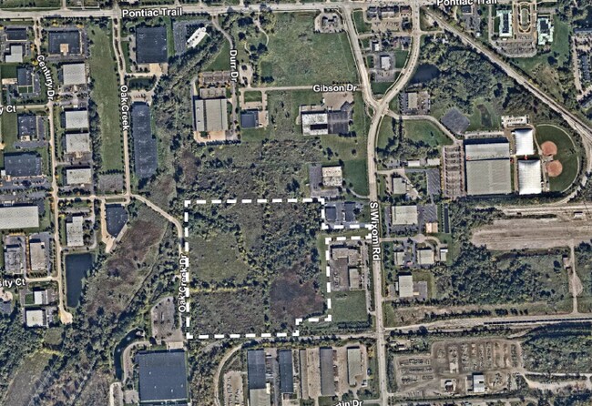
30625 S Wixom Rd
22-06-200-028
T1N, R8E, SEC 6 PART OF NE FRAC 1/4 BEG AT PT DIST N 100 FT & N 89-36-15 W 880 FT FROM E 1/4 COR, TH N 89-36-15 W 964 FT, TH N 00-06-49 W 1230.60 FT, TH N 89-32-17 E 1361.46 FT, TH S 270 FT, TH N 89-32-17 E 425 FT, TH S 87.32 FT, TH S 89-32-17 W 410
Industrialacreage
OAKLAND
M-1
Michigan
AE The base floodplain where base flood elevations are provided. AE Zones are now used on new format FIRMs instead of A1-A30 Zones.
38.34 AC
2025
Central I-96 Corridor
2025
Detroit
133102
Detroit-Warren-Dearborn, MI
NEARBY LISTINGS FOR SALE OR LEASE
DEMOGRAPHICS near 30625 S Wixom Rd
1 mile
3 mile
5 mile
2025 Total Population
2,945
40,092
106,661
2030 Population
2,867
40,452
109,098
Pop Growth 2025-2030
(2.65%)
+ 0.90%
+ 2.28%
Average Age
37
39
41
2025 Total Households
1,686
17,491
43,671
HH Growth 2025-2030
(3.32%)
+ 0.45%
+ 2.01%
Median Household Inc
$65,948
$80,728
$99,103
Avg Household Size
1.70
2.30
2.40
2025 Avg HH Vehicles
2.00
2.00
2.00
Median Home Value
$332,353
$359,410
$394,081
Median Year Built
1982
1991
1993
Nearby Places
Map Layers
Map Styles
 Street
 Aerial
Layers
 Traffic
 Biking
Places
Listings with unknown addresses are not visible on the map
- Restaurants
- Banks
- Shops
- Fitness
- Groceries
PUBLIC TRANSPORTATION
AIRPORT
Detroit Metro Wayne County
Drive
Walk
Distance
Detroit Metro Wayne County
38 min
31.5 mi
Freight Ports
Port of Toledo
Drive
Walk
Distance
Port of Toledo
87 min
73.1 mi
SALE & LEASE HISTORY
LISTING DATE
SALE/LEASE

Dec 16, 2022
For Sale
Nearby Properties
Address
Land Use
TOTAL SIZE
Lot Size
Zoning
Address
Land Use
TOTAL SIZE
Lot Size
Zoning
873,288 SF
Address
Land Use
TOTAL SIZE
Lot Size
Zoning
741,000 SF
Address
Land Use
TOTAL SIZE
Lot Size
Zoning
72.63 AC
RM-1
Address
Land Use
TOTAL SIZE
Lot Size
Zoning
86.19 AC
RC2
Address
Land Use
TOTAL SIZE
Lot Size
Zoning
563,160 SF
47.06 AC
Address
Land Use
TOTAL SIZE
Lot Size
Zoning
12,872 SF
43.06 AC
RM-1
Address
Land Use
TOTAL SIZE
Lot Size
Zoning
317,215 SF
23.63 AC
Address
Land Use
TOTAL SIZE
Lot Size
Zoning
20.71 AC
OSC
Address
Land Use
TOTAL SIZE
Lot Size
Zoning
59.71 AC
RM-1
Address
Land Use
TOTAL SIZE
Lot Size
Zoning
306,280 SF
Address
Land Use
TOTAL SIZE
Lot Size
Zoning
144.50 AC
OSC
Address
Land Use
TOTAL SIZE
Lot Size
Zoning
63.31 AC
OST-EXO
Address
Land Use
TOTAL SIZE
Lot Size
Zoning
325,725 SF
30.46 AC
Address
Land Use
TOTAL SIZE
Lot Size
Zoning
184,225 SF
13.84 AC
OSC
Address
Land Use
TOTAL SIZE
Lot Size
Zoning
38.85 AC
RC2
Address
Land Use
TOTAL SIZE
Lot Size
Zoning
256,880 SF
Address
Land Use
TOTAL SIZE
Lot Size
Zoning
OST-EXO
Address
Land Use
TOTAL SIZE
Lot Size
Zoning
Address
Land Use
TOTAL SIZE
Lot Size
Zoning
140,366 SF
30.67 AC
II
Address
Land Use
TOTAL SIZE
Lot Size
Zoning
132,288 SF
Address
Land Use
TOTAL SIZE
Lot Size
Zoning
4,140 SF
120 AC
MM
Address
Land Use
TOTAL SIZE
Lot Size
Zoning
126,720 SF
8.31 AC
Address
Land Use
TOTAL SIZE
Lot Size
Zoning
172,700 SF
Address
Land Use
TOTAL SIZE
Lot Size
Zoning
7,471 SF
114.63 AC
MM
Address
Land Use
TOTAL SIZE
Lot Size
Zoning
25.58 AC
RC1
Address
Land Use
TOTAL SIZE
Lot Size
Zoning
243,502 SF
Address
Land Use
TOTAL SIZE
Lot Size
Zoning
154,490 SF
Address
Land Use
TOTAL SIZE
Lot Size
Zoning
279,807 SF
31.24 AC
II
Address
Land Use
TOTAL SIZE
Lot Size
Zoning
200,926 SF
30.87 AC
M1
Address
Land Use
TOTAL SIZE
Lot Size
Zoning
287,382 SF
42.91 AC
II
The World's #1 Commercial Real Estate Marketplace
Connect with us
© 2026 CoStar Group
The information above has been obtained from sources believed reliable. While we do not doubt its accuracy we have not verified it and make no guarantee, warranty or representation about it. It is your responsibility to independently confirm its accuracy and completeness. Any projections, opinions, assumptions, or estimates used are for example only and do not represent the current or future performance of the property. The value of this transaction to you depends on tax and other factors which should be evaluated by your tax, financial, and legal advisors. You and your advisors should conduct a careful, independent investigation of the property to determine to your satisfaction the suitability of the property for your needs.