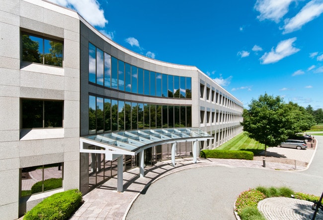
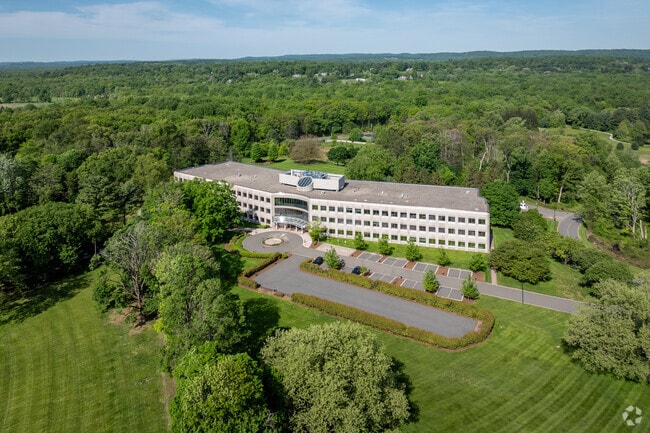
Property Record
Woodland Rd, Madison, NJ 07940

NEARBY LISTINGS FOR SALE OR LEASE
Property Detail
Woodland Rd
17-03202-0000-00008
Morris
Officebuilding
New Jersey
X
8
34013C0075F
20 AC
2024
Morristown Region
2025
Northern New Jersey
043000
Newark, NJ-PA
146,538 SF
DEMOGRAPHICS near Woodland Rd
1 Mile
3 Mile
5 Mile
2024 Total Population
6,311
48,448
134,902
2029 Population
6,278
48,473
134,658
Pop Growth 2024-2029
(0.52%)
+ 0.05%
(0.18%)
Average Age
36
40
41
2024 Total Households
1,819
17,132
49,866
HH Growth 2024-2029
(0.05%)
+ 0.22%
(0.16%)
Median Household Inc
$180,086
$169,462
$150,223
Avg Household Size
2.60
2.60
2.60
2024 Avg HH Vehicles
2.00
2.00
2.00
Median Home Value
$882,165
$803,182
$752,208
Median Year Built
1958
1961
1964
Nearby Places
Map Layers
Map Styles
 Street
 Aerial
- Restaurants
- Banks
- Shops
- Fitness
- Groceries
PUBLIC TRANSPORTATION
COMMUTER RAIL
Convent Station (Morris & Essex Morristown Line - NJ Transit Commuter Rail (NJ Transit))
DRIVE
WALK
Distance
Convent Station (Morris & Essex Morristown Line - NJ Transit Commuter Rail (NJ Transit))
8 min
2.0 mi
Madison (Morris & Essex Morristown Line - NJ Transit Commuter Rail (NJ Transit))
DRIVE
WALK
Distance
Madison (Morris & Essex Morristown Line - NJ Transit Commuter Rail (NJ Transit))
8 min
2.1 mi
AIRPORT
Newark Liberty International
DRIVE
WALK
Distance
Newark Liberty International
32 min
18.7 mi
LaGuardia
DRIVE
WALK
Distance
LaGuardia
66 min
38.0 mi
Freight Ports
Maher Terminal
DRIVE
WALK
Distance
Maher Terminal
35 min
19.2 mi
SALE & LEASE HISTORY
LISTING DATE
SALE/LEASE

May 14, 2024
For Lease
Nearby Properties
Address
Land Use
TOTAL SIZE
Lot Size
Zoning
Address
Land Use
TOTAL SIZE
Lot Size
Zoning
66,201 SF
168.40 AC
R-3
Address
Land Use
TOTAL SIZE
Lot Size
Zoning
23.01 AC
R-2
Address
Land Use
TOTAL SIZE
Lot Size
Zoning
64.80 AC
C-4
Address
Land Use
TOTAL SIZE
Lot Size
Zoning
72,698 SF
133.64 AC
U
Address
Land Use
TOTAL SIZE
Lot Size
Zoning
9.80 AC
Address
Land Use
TOTAL SIZE
Lot Size
Zoning
50.01 AC
PCDO
Address
Land Use
TOTAL SIZE
Lot Size
Zoning
19.05 AC
R-2
Address
Land Use
TOTAL SIZE
Lot Size
Zoning
270,000 SF
15.32 AC
OR
Address
Land Use
TOTAL SIZE
Lot Size
Zoning
10.94 AC
Address
Land Use
TOTAL SIZE
Lot Size
Zoning
8.64 AC
RG
Address
Land Use
TOTAL SIZE
Lot Size
Zoning
43.60 AC
C-4
Address
Land Use
TOTAL SIZE
Lot Size
Zoning
59,369 SF
86.79 AC
R-44
Address
Land Use
TOTAL SIZE
Lot Size
Zoning
10.42 AC
Address
Land Use
TOTAL SIZE
Lot Size
Zoning
27.20 AC
PODS
Address
Land Use
TOTAL SIZE
Lot Size
Zoning
304,213 SF
21.73 AC
PODS
Address
Land Use
TOTAL SIZE
Lot Size
Zoning
34.13 AC
OB
Address
Land Use
TOTAL SIZE
Lot Size
Zoning
322,575 SF
32.28 AC
OL40
Address
Land Use
TOTAL SIZE
Lot Size
Zoning
6.56 AC
OB
Address
Land Use
TOTAL SIZE
Lot Size
Zoning
6.64 AC
Address
Land Use
TOTAL SIZE
Lot Size
Zoning
19.35 AC
0L40
Address
Land Use
TOTAL SIZE
Lot Size
Zoning
20 AC
PCDO
Address
Land Use
TOTAL SIZE
Lot Size
Zoning
200,360 SF
16.20 AC
OL-5
Address
Land Use
TOTAL SIZE
Lot Size
Zoning
18.29 AC
C-1
Address
Land Use
TOTAL SIZE
Lot Size
Zoning
252,828 SF
44.53 AC
C-1
Address
Land Use
TOTAL SIZE
Lot Size
Zoning
16.72 AC
C-3
Address
Land Use
TOTAL SIZE
Lot Size
Zoning
27.50 AC
C-4
Address
Land Use
TOTAL SIZE
Lot Size
Zoning
151,848 SF
15.40 AC
OL15
Address
Land Use
TOTAL SIZE
Lot Size
Zoning
15.39 AC
R-7
Address
Land Use
TOTAL SIZE
Lot Size
Zoning
208,000 SF
20.20 AC
OL40
The World's #1 Commercial Real Estate Marketplace
Connect with us
© 2025 CoStar Group
The information above has been obtained from sources believed reliable. While we do not doubt its accuracy we have not verified it and make no guarantee, warranty or representation about it. It is your responsibility to independently confirm its accuracy and completeness. Any projections, opinions, assumptions, or estimates used are for example only and do not represent the current or future performance of the property. The value of this transaction to you depends on tax and other factors which should be evaluated by your tax, financial, and legal advisors. You and your advisors should conduct a careful, independent investigation of the property to determine to your satisfaction the suitability of the property for your needs.