Property Record
Woodlawn Rd, Mansfield, GA 30055
NEARBY LISTINGS FOR SALE OR LEASE
Property Detail
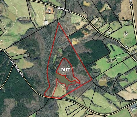
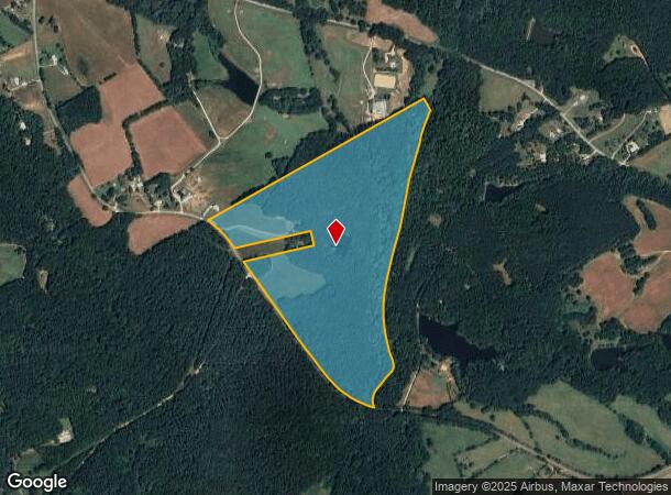
Woodlawn Rd
Atlanta-Sandy Springs-Roswell, GA
Woodlawn & Elks Club Road
0116000000011000
95.994AC WOODLAWN RD
Privatepreserveopenspacevacantlandforestlandconservation
Newton
A
Georgia
13217C0145D
95.99 AC
2025
Newton County
2025
Atlanta
100203
DEMOGRAPHICS near Woodlawn Rd
1 Mile
3 Mile
5 Mile
2024 Total Population
189
3,459
11,807
2029 Population
212
3,855
13,110
Pop Growth 2024-2029
+ 12.17%
+ 11.45%
+ 11.04%
Average Age
41
40
40
2024 Total Households
65
1,220
4,121
HH Growth 2024-2029
+ 12.31%
+ 11.72%
+ 11.33%
Median Household Inc
$114,062
$101,724
$99,813
Avg Household Size
2.70
2.80
2.80
2024 Avg HH Vehicles
2.00
2.00
2.00
Median Home Value
$308,000
$312,350
$307,390
Median Year Built
1995
1995
1998
Nearby Places
Map Layers
Map Styles
 Street
 Aerial
- Restaurants
- Banks
- Shops
- Fitness
- Groceries
SALE & LEASE HISTORY
LISTING DATE
SALE/LEASE

May 16, 2017
For Sale
Nearby Properties
Address
Land Use
TOTAL SIZE
Lot Size
Zoning
Address
Land Use
TOTAL SIZE
Lot Size
Zoning
480.57 AC
AR
Address
Land Use
TOTAL SIZE
Lot Size
Zoning
51,772 SF
16 AC
E6
Address
Land Use
TOTAL SIZE
Lot Size
Zoning
49,742 SF
6.52 AC
E6
Address
Land Use
TOTAL SIZE
Lot Size
Zoning
30,600 SF
13.74 AC
Address
Land Use
TOTAL SIZE
Lot Size
Zoning
19,016 SF
21.46 AC
E2
Address
Land Use
TOTAL SIZE
Lot Size
Zoning
21,826 SF
2.74 AC
Address
Land Use
TOTAL SIZE
Lot Size
Zoning
13,300 SF
20.59 AC
AR
Address
Land Use
TOTAL SIZE
Lot Size
Zoning
36,470 SF
25.16 AC
I1
Address
Land Use
TOTAL SIZE
Lot Size
Zoning
185 AC
A
Address
Land Use
TOTAL SIZE
Lot Size
Zoning
15,850 SF
10 AC
I1
Address
Land Use
TOTAL SIZE
Lot Size
Zoning
184 AC
A
Address
Land Use
TOTAL SIZE
Lot Size
Zoning
173.40 AC
A
Address
Land Use
TOTAL SIZE
Lot Size
Zoning
6,440 SF
1.98 AC
C1
Address
Land Use
TOTAL SIZE
Lot Size
Zoning
81.17 AC
AR
Address
Land Use
TOTAL SIZE
Lot Size
Zoning
160 AC
A
Address
Land Use
TOTAL SIZE
Lot Size
Zoning
103.12 AC
A
Address
Land Use
TOTAL SIZE
Lot Size
Zoning
22 AC
MHP
Address
Land Use
TOTAL SIZE
Lot Size
Zoning
150 AC
AR
Address
Land Use
TOTAL SIZE
Lot Size
Zoning
157.87 AC
A
Address
Land Use
TOTAL SIZE
Lot Size
Zoning
4,200 SF
1.96 AC
C1
Address
Land Use
TOTAL SIZE
Lot Size
Zoning
92.44 AC
A
Address
Land Use
TOTAL SIZE
Lot Size
Zoning
2,844 SF
184.31 AC
A1
Address
Land Use
TOTAL SIZE
Lot Size
Zoning
9,470 SF
3.01 AC
C1
Address
Land Use
TOTAL SIZE
Lot Size
Zoning
124.38 AC
AR
Address
Land Use
TOTAL SIZE
Lot Size
Zoning
7,920 SF
1.57 AC
C1
Address
Land Use
TOTAL SIZE
Lot Size
Zoning
117.12 AC
A
Address
Land Use
TOTAL SIZE
Lot Size
Zoning
56.57 AC
Address
Land Use
TOTAL SIZE
Lot Size
Zoning
84.90 AC
AR
Address
Land Use
TOTAL SIZE
Lot Size
Zoning
1,850 SF
69.13 AC
A1
Address
Land Use
TOTAL SIZE
Lot Size
Zoning
89.28 AC
A
The World's #1 Commercial Real Estate Marketplace
Connect with us
© 2026 CoStar Group
The information above has been obtained from sources believed reliable. While we do not doubt its accuracy we have not verified it and make no guarantee, warranty or representation about it. It is your responsibility to independently confirm its accuracy and completeness. Any projections, opinions, assumptions, or estimates used are for example only and do not represent the current or future performance of the property. The value of this transaction to you depends on tax and other factors which should be evaluated by your tax, financial, and legal advisors. You and your advisors should conduct a careful, independent investigation of the property to determine to your satisfaction the suitability of the property for your needs.