Property Record
Woodruff, Rockwood, MI 48173
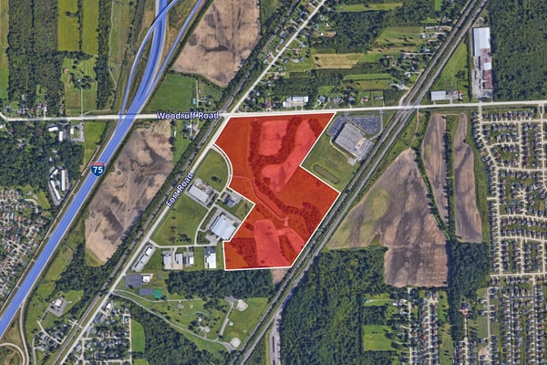


This Property Is For Sale
NEARBY LISTINGS FOR SALE OR LEASE
Property Detail
Woodruff
Detroit-Warren-Dearborn, MI
Stuart And Hursts Rockwood
52-008-99-0001-721
*10B2C,D1B3, E1A2C* PT OF THE NE 1/4 OF SEC 10 T5S R10E DESC AS BEG AT THE N 1/4 COR OF SAID SEC 10 - TH S 89D 44M 45S E
Industrialacreage
Wayne
A
Michigan
26163C0528F
0001
0
60.82 AC
2025
Downriver South
592000
Detroit
DEMOGRAPHICS near Woodruff
1 Mile
3 Mile
5 Mile
2024 Total Population
4,394
28,041
67,537
2029 Population
4,225
26,962
65,081
Pop Growth 2024-2029
(3.85%)
(3.85%)
(3.64%)
Average Age
39
41
42
2024 Total Households
1,549
11,136
27,421
HH Growth 2024-2029
(3.81%)
(3.83%)
(3.64%)
Median Household Inc
$96,801
$78,461
$80,259
Avg Household Size
2.80
2.50
2.40
2024 Avg HH Vehicles
2.00
2.00
2.00
Median Home Value
$245,228
$204,270
$218,623
Median Year Built
1992
1976
1977
Nearby Places
Map Layers
Map Styles
 Street
 Aerial
- Restaurants
- Banks
- Shops
- Fitness
- Groceries
PUBLIC TRANSPORTATION
AIRPORT
Detroit Metro Wayne County
DRIVE
WALK
Distance
Detroit Metro Wayne County
26 min
17.1 mi
Windsor International
DRIVE
WALK
Distance
Windsor International
51 min
32.7 mi
Freight Ports
Port of Toledo
DRIVE
WALK
Distance
Port of Toledo
51 min
38.5 mi
Nearby Properties
Address
Land Use
TOTAL SIZE
Lot Size
Zoning
Address
Land Use
TOTAL SIZE
Lot Size
Zoning
3,189,689 SF
228.88 AC
Address
Land Use
TOTAL SIZE
Lot Size
Zoning
215,724 SF
Address
Land Use
TOTAL SIZE
Lot Size
Zoning
235,489 SF
23.47 AC
Address
Land Use
TOTAL SIZE
Lot Size
Zoning
249,836 SF
22.18 AC
AG
Address
Land Use
TOTAL SIZE
Lot Size
Zoning
1,021,918 SF
163.58 AC
Address
Land Use
TOTAL SIZE
Lot Size
Zoning
3,280 SF
99.72 AC
Address
Land Use
TOTAL SIZE
Lot Size
Zoning
33,600 SF
100.03 AC
Address
Land Use
TOTAL SIZE
Lot Size
Zoning
92,397 SF
12.63 AC
PUD
Address
Land Use
TOTAL SIZE
Lot Size
Zoning
59,427 SF
5.50 AC
Address
Land Use
TOTAL SIZE
Lot Size
Zoning
68,409 SF
64.56 AC
Address
Land Use
TOTAL SIZE
Lot Size
Zoning
95,650 SF
73.78 AC
Address
Land Use
TOTAL SIZE
Lot Size
Zoning
52.37 AC
Address
Land Use
TOTAL SIZE
Lot Size
Zoning
18,678 SF
3.10 AC
R1-ONE
Address
Land Use
TOTAL SIZE
Lot Size
Zoning
2,816 SF
86.70 AC
RESIDE
Address
Land Use
TOTAL SIZE
Lot Size
Zoning
146,300 SF
25.84 AC
Address
Land Use
TOTAL SIZE
Lot Size
Zoning
101,861 SF
15.33 AC
B-2
Address
Land Use
TOTAL SIZE
Lot Size
Zoning
164,567 SF
13.78 AC
RESIDE
Address
Land Use
TOTAL SIZE
Lot Size
Zoning
114,165 SF
13.07 AC
Address
Land Use
TOTAL SIZE
Lot Size
Zoning
551,184 SF
RESIDE
Address
Land Use
TOTAL SIZE
Lot Size
Zoning
124,602 SF
10.20 AC
Address
Land Use
TOTAL SIZE
Lot Size
Zoning
52,085 SF
5 AC
RM-1
Address
Land Use
TOTAL SIZE
Lot Size
Zoning
139.98 AC
Address
Land Use
TOTAL SIZE
Lot Size
Zoning
551,184 SF
42.34 AC
RESIDE
Address
Land Use
TOTAL SIZE
Lot Size
Zoning
130,627 SF
20.42 AC
Address
Land Use
TOTAL SIZE
Lot Size
Zoning
7,222 SF
58.71 AC
Address
Land Use
TOTAL SIZE
Lot Size
Zoning
98,823 SF
16.38 AC
Address
Land Use
TOTAL SIZE
Lot Size
Zoning
65,435 SF
24.77 AC
RESIDE
Address
Land Use
TOTAL SIZE
Lot Size
Zoning
176,644 SF
8.78 AC
Address
Land Use
TOTAL SIZE
Lot Size
Zoning
16,980 SF
6.11 AC
RESIDE
Address
Land Use
TOTAL SIZE
Lot Size
Zoning
13,488 SF
247.69 AC
The World's #1 Commercial Real Estate Marketplace
Connect with us
© 2026 CoStar Group
The information above has been obtained from sources believed reliable. While we do not doubt its accuracy we have not verified it and make no guarantee, warranty or representation about it. It is your responsibility to independently confirm its accuracy and completeness. Any projections, opinions, assumptions, or estimates used are for example only and do not represent the current or future performance of the property. The value of this transaction to you depends on tax and other factors which should be evaluated by your tax, financial, and legal advisors. You and your advisors should conduct a careful, independent investigation of the property to determine to your satisfaction the suitability of the property for your needs.