Property Record
Wren Tpke, Belmont, NC 28012


NEARBY LISTINGS FOR SALE OR LEASE
Property Detail
Wren Tpke
Charlotte-Concord-Gastonia, NC-SC
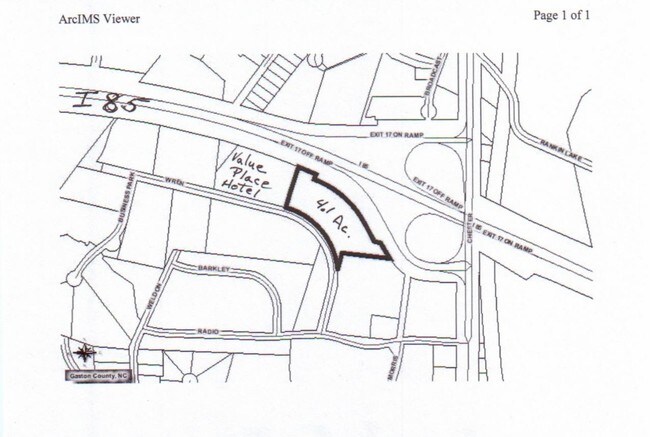
Value Place Hotel Site
212756
VALUE PLACE HOTEL SITE TRACT 2 01 001A 025 02 000
Commercialnec
Gaston
X
North Carolina
3710354600J
4 AC
2025
Gaston County
2025
Charlotte
033100
DEMOGRAPHICS near Wren Tpke
1 Mile
3 Mile
5 Mile
2024 Total Population
3,696
44,481
92,623
2029 Population
3,973
47,488
98,842
Pop Growth 2024-2029
+ 7.49%
+ 6.76%
+ 6.71%
Average Age
37
39
39
2024 Total Households
1,362
17,761
37,015
HH Growth 2024-2029
+ 7.86%
+ 6.89%
+ 6.86%
Median Household Inc
$21,023
$40,955
$45,069
Avg Household Size
2.30
2.40
2.40
2024 Avg HH Vehicles
1.00
2.00
2.00
Median Home Value
$102,273
$158,435
$175,743
Median Year Built
1970
1967
1974
Nearby Places
Map Layers
Map Styles
 Street
 Aerial
- Restaurants
- Banks
- Shops
- Fitness
- Groceries
PUBLIC TRANSPORTATION
COMMUTER RAIL
Gastonia Amtrak Station (Crescent - Amtrak)
DRIVE
WALK
Distance
Gastonia Amtrak Station (Crescent - Amtrak)
6 min
3.0 mi
AIRPORT
Charlotte/Douglas International
DRIVE
WALK
Distance
Charlotte/Douglas International
31 min
18.3 mi
Concord-Padgett Regional
DRIVE
WALK
Distance
Concord-Padgett Regional
46 min
34.7 mi
Freight Ports
North Charleston Terminal
DRIVE
WALK
Distance
North Charleston Terminal
246 min
214.4 mi
SALE & LEASE HISTORY
LISTING DATE
SALE/LEASE

Mar 21, 2019
For Sale
Nearby Properties
Address
Land Use
TOTAL SIZE
Lot Size
Zoning
Address
Land Use
TOTAL SIZE
Lot Size
Zoning
56,000 SF
23.22 AC
GOV01
Address
Land Use
TOTAL SIZE
Lot Size
Zoning
68.71 AC
Address
Land Use
TOTAL SIZE
Lot Size
Zoning
11,696 SF
159.68 AC
Address
Land Use
TOTAL SIZE
Lot Size
Zoning
4,519 SF
2.10 AC
Address
Land Use
TOTAL SIZE
Lot Size
Zoning
159,263 SF
9.83 AC
GOV01
Address
Land Use
TOTAL SIZE
Lot Size
Zoning
Address
Land Use
TOTAL SIZE
Lot Size
Zoning
17.37 AC
Address
Land Use
TOTAL SIZE
Lot Size
Zoning
312,465 SF
35.23 AC
Address
Land Use
TOTAL SIZE
Lot Size
Zoning
9,792 SF
14.31 AC
APT01
Address
Land Use
TOTAL SIZE
Lot Size
Zoning
192,315 SF
44.12 AC
INDS1
Address
Land Use
TOTAL SIZE
Lot Size
Zoning
103,890 SF
8.81 AC
OFF04
Address
Land Use
TOTAL SIZE
Lot Size
Zoning
2,688 SF
22.48 AC
OFF01
Address
Land Use
TOTAL SIZE
Lot Size
Zoning
4,568 SF
24.69 AC
PUB01
Address
Land Use
TOTAL SIZE
Lot Size
Zoning
2,250 SF
27.79 AC
OFF01
Address
Land Use
TOTAL SIZE
Lot Size
Zoning
1,680 SF
19.08 AC
OFF01
Address
Land Use
TOTAL SIZE
Lot Size
Zoning
Address
Land Use
TOTAL SIZE
Lot Size
Zoning
539,988 SF
36.32 AC
STOR6
Address
Land Use
TOTAL SIZE
Lot Size
Zoning
192,978 SF
22.67 AC
RET05
Address
Land Use
TOTAL SIZE
Lot Size
Zoning
22.85 AC
Address
Land Use
TOTAL SIZE
Lot Size
Zoning
Address
Land Use
TOTAL SIZE
Lot Size
Zoning
123,948 SF
6.94 AC
GOV05
Address
Land Use
TOTAL SIZE
Lot Size
Zoning
0.79 AC
RET01
Address
Land Use
TOTAL SIZE
Lot Size
Zoning
411,076 SF
67.01 AC
INDS2
Address
Land Use
TOTAL SIZE
Lot Size
Zoning
53,260 SF
2.18 AC
HOTL1
Address
Land Use
TOTAL SIZE
Lot Size
Zoning
176,657 SF
16.19 AC
Address
Land Use
TOTAL SIZE
Lot Size
Zoning
112,513 SF
13.09 AC
PUB01
Address
Land Use
TOTAL SIZE
Lot Size
Zoning
154,681 SF
63.07 AC
INDS1
Address
Land Use
TOTAL SIZE
Lot Size
Zoning
83,664 SF
2.23 AC
HOTL1
Address
Land Use
TOTAL SIZE
Lot Size
Zoning
5,880 SF
10.17 AC
APT01
Address
Land Use
TOTAL SIZE
Lot Size
Zoning
1,760 SF
3.51 AC
The World's #1 Commercial Real Estate Marketplace
Connect with us
© 2026 CoStar Group
The information above has been obtained from sources believed reliable. While we do not doubt its accuracy we have not verified it and make no guarantee, warranty or representation about it. It is your responsibility to independently confirm its accuracy and completeness. Any projections, opinions, assumptions, or estimates used are for example only and do not represent the current or future performance of the property. The value of this transaction to you depends on tax and other factors which should be evaluated by your tax, financial, and legal advisors. You and your advisors should conduct a careful, independent investigation of the property to determine to your satisfaction the suitability of the property for your needs.