Property Record
1705 Denfield Dr, Benson, MN 56215
NEARBY LISTINGS FOR SALE OR LEASE
-
-
View all Benson listings for sale on LoopNet.com
Property Detail
1705 Denfield Dr
Other Market Areas
Benson-Acre Lots
23-1450-000
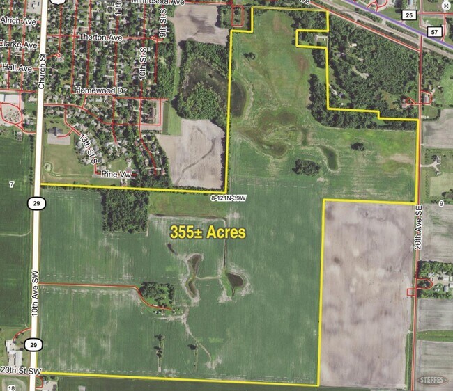
NW1/4 OF NE1/4 AND S1/2 OF NE1/4 EXC A PC 260'X 419' LESS A PC 124.5 FT X 700 FT ALSO EXC PT NW1/4-NE1/4 DESC AS FOLLOWS:
Agriculturalland
Swift
X
Minnesota
27151C0290C
43
2025
115.50 AC
2025
Minnesota Central Area
960200
DEMOGRAPHICS near 1705 Denfield Dr
1 Mile
3 Mile
5 Mile
2024 Total Population
1,753
4,020
4,242
2029 Population
1,735
3,978
4,191
Pop Growth 2024-2029
(1.03%)
(1.04%)
(1.20%)
Average Age
45
43
43
2024 Total Households
762
1,697
1,784
HH Growth 2024-2029
(1.05%)
(1.12%)
(1.23%)
Median Household Inc
$45,880
$49,462
$50,635
Avg Household Size
2.00
2.20
2.20
2024 Avg HH Vehicles
2.00
2.00
2.00
Median Home Value
$115,248
$140,313
$142,328
Median Year Built
1953
1959
1958
Nearby Places
Map Layers
Map Styles
 Street
 Aerial
- Restaurants
- Banks
- Shops
- Fitness
- Groceries
SALE & LEASE HISTORY
LISTING DATE
SALE/LEASE

Mar 04, 2020
For Sale
Nearby Properties
Address
Land Use
TOTAL SIZE
Lot Size
Zoning
Address
Land Use
TOTAL SIZE
Lot Size
Zoning
4.74 AC
Address
Land Use
TOTAL SIZE
Lot Size
Zoning
2.14 AC
Address
Land Use
TOTAL SIZE
Lot Size
Zoning
26.90 AC
Address
Land Use
TOTAL SIZE
Lot Size
Zoning
1.75 AC
Address
Land Use
TOTAL SIZE
Lot Size
Zoning
169.35 AC
Address
Land Use
TOTAL SIZE
Lot Size
Zoning
7.61 AC
Address
Land Use
TOTAL SIZE
Lot Size
Zoning
7.39 AC
Address
Land Use
TOTAL SIZE
Lot Size
Zoning
1.71 AC
Address
Land Use
TOTAL SIZE
Lot Size
Zoning
210 AC
Address
Land Use
TOTAL SIZE
Lot Size
Zoning
256.39 AC
Address
Land Use
TOTAL SIZE
Lot Size
Zoning
185.80 AC
Address
Land Use
TOTAL SIZE
Lot Size
Zoning
Address
Land Use
TOTAL SIZE
Lot Size
Zoning
8.12 AC
Address
Land Use
TOTAL SIZE
Lot Size
Zoning
197 AC
Address
Land Use
TOTAL SIZE
Lot Size
Zoning
160 AC
Address
Land Use
TOTAL SIZE
Lot Size
Zoning
2.75 AC
Address
Land Use
TOTAL SIZE
Lot Size
Zoning
160 AC
Address
Land Use
TOTAL SIZE
Lot Size
Zoning
146.32 AC
Address
Land Use
TOTAL SIZE
Lot Size
Zoning
9.67 AC
Address
Land Use
TOTAL SIZE
Lot Size
Zoning
4.66 AC
Address
Land Use
TOTAL SIZE
Lot Size
Zoning
192.05 AC
Address
Land Use
TOTAL SIZE
Lot Size
Zoning
2.07 AC
Address
Land Use
TOTAL SIZE
Lot Size
Zoning
83.44 AC
Address
Land Use
TOTAL SIZE
Lot Size
Zoning
8.17 AC
Address
Land Use
TOTAL SIZE
Lot Size
Zoning
0.34 AC
Address
Land Use
TOTAL SIZE
Lot Size
Zoning
220.36 AC
Address
Land Use
TOTAL SIZE
Lot Size
Zoning
10.35 AC
Address
Land Use
TOTAL SIZE
Lot Size
Zoning
1,190 SF
1.30 AC
Address
Land Use
TOTAL SIZE
Lot Size
Zoning
1.72 AC
Address
Land Use
TOTAL SIZE
Lot Size
Zoning
1.52 AC
The World's #1 Commercial Real Estate Marketplace
Connect with us
© 2025 CoStar Group
The information above has been obtained from sources believed reliable. While we do not doubt its accuracy we have not verified it and make no guarantee, warranty or representation about it. It is your responsibility to independently confirm its accuracy and completeness. Any projections, opinions, assumptions, or estimates used are for example only and do not represent the current or future performance of the property. The value of this transaction to you depends on tax and other factors which should be evaluated by your tax, financial, and legal advisors. You and your advisors should conduct a careful, independent investigation of the property to determine to your satisfaction the suitability of the property for your needs.