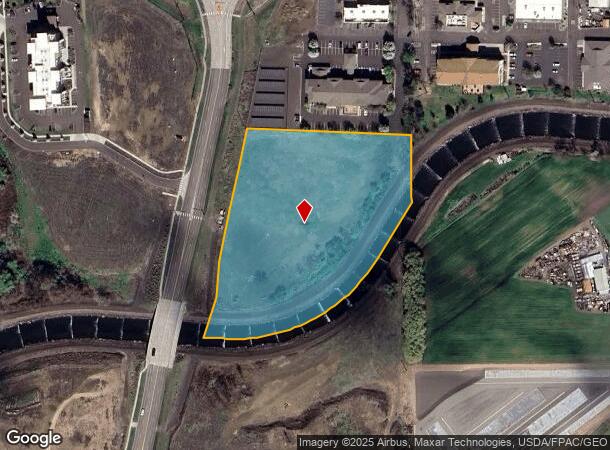
Property Record
Ne Myra Rd, Walla Walla, WA 99362

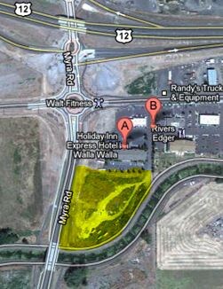
NEARBY LISTINGS FOR SALE OR LEASE
Property Detail
Ne Myra Rd
Other Market Areas
Mill Creek
Walla Walla, WA
24-7-35 LOT 4 OF BINDING SITE PLAN (AMENDED)(PT IN SE1/4SE1/4)LESSMILL CREEK TO THE S
350724440022
Walla Walla
Vacantlandnec
Washington
2024
4
2024
4.11 AC
920600
Washington State Area
DEMOGRAPHICS near Ne Myra Rd
1 Mile
3 Mile
5 Mile
2024 Total Population
3,894
42,366
53,566
2029 Population
3,915
42,989
54,316
Pop Growth 2024-2029
+ 0.54%
+ 1.47%
+ 1.40%
Average Age
44
41
41
2024 Total Households
1,261
15,951
20,207
HH Growth 2024-2029
+ 0.71%
+ 1.60%
+ 1.46%
Median Household Inc
$47,902
$57,143
$63,355
Avg Household Size
2.30
2.30
2.40
2024 Avg HH Vehicles
2.00
2.00
2.00
Median Home Value
$159,728
$336,007
$346,596
Median Year Built
1972
1972
1974
Nearby Places
- Restaurants
- Banks
- Shops
- Fitness
- Groceries
PUBLIC TRANSPORTATION
AIRPORT
Walla Walla Regional
DRIVE
WALK
Distance
Walla Walla Regional
8 min
5.4 mi
Freight Ports
Port of Tacoma
DRIVE
WALK
Distance
Port of Tacoma
326 min
283.1 mi
SALE & LEASE HISTORY
LISTING DATE
SALE/LEASE

Sep 24, 2016
For Sale
Jul 23, 2019
For Sale
Feb 27, 2018
For Sale
Nearby Properties
Address
Land Use
TOTAL SIZE
Lot Size
Zoning
Address
Land Use
TOTAL SIZE
Lot Size
Zoning
141,493 SF
19.10 AC
Address
Land Use
TOTAL SIZE
Lot Size
Zoning
3.14 AC
Address
Land Use
TOTAL SIZE
Lot Size
Zoning
118,836 SF
9.43 AC
Address
Land Use
TOTAL SIZE
Lot Size
Zoning
128,366 SF
14.78 AC
Address
Land Use
TOTAL SIZE
Lot Size
Zoning
200,872 SF
42.83 AC
Address
Land Use
TOTAL SIZE
Lot Size
Zoning
128,578 SF
10.56 AC
Address
Land Use
TOTAL SIZE
Lot Size
Zoning
205,690 SF
19.83 AC
Address
Land Use
TOTAL SIZE
Lot Size
Zoning
251,468 SF
6.17 AC
Address
Land Use
TOTAL SIZE
Lot Size
Zoning
65,472 SF
1.79 AC
Address
Land Use
TOTAL SIZE
Lot Size
Zoning
171,813 SF
20.38 AC
Address
Land Use
TOTAL SIZE
Lot Size
Zoning
223,200 SF
11.21 AC
Address
Land Use
TOTAL SIZE
Lot Size
Zoning
73,529 SF
4.32 AC
Address
Land Use
TOTAL SIZE
Lot Size
Zoning
50,745 SF
4.10 AC
Address
Land Use
TOTAL SIZE
Lot Size
Zoning
91,972 SF
3.47 AC
Address
Land Use
TOTAL SIZE
Lot Size
Zoning
52,062 SF
9 AC
Address
Land Use
TOTAL SIZE
Lot Size
Zoning
76,064 SF
10.67 AC
Address
Land Use
TOTAL SIZE
Lot Size
Zoning
105,028 SF
4.50 AC
Address
Land Use
TOTAL SIZE
Lot Size
Zoning
52,166 SF
9.55 AC
Address
Land Use
TOTAL SIZE
Lot Size
Zoning
105,989 SF
0.69 AC
Address
Land Use
TOTAL SIZE
Lot Size
Zoning
55,152 SF
2.21 AC
Address
Land Use
TOTAL SIZE
Lot Size
Zoning
121.70 AC
Address
Land Use
TOTAL SIZE
Lot Size
Zoning
52,572 SF
13.13 AC
Address
Land Use
TOTAL SIZE
Lot Size
Zoning
55,687 SF
4 AC
Address
Land Use
TOTAL SIZE
Lot Size
Zoning
40,562 SF
1.24 AC
Address
Land Use
TOTAL SIZE
Lot Size
Zoning
59,987 SF
3.21 AC
Address
Land Use
TOTAL SIZE
Lot Size
Zoning
53,838 SF
5.75 AC
Address
Land Use
TOTAL SIZE
Lot Size
Zoning
80,188 SF
19.67 AC
Address
Land Use
TOTAL SIZE
Lot Size
Zoning
65,624 SF
7.20 AC
Address
Land Use
TOTAL SIZE
Lot Size
Zoning
61,027 SF
3.46 AC
Address
Land Use
TOTAL SIZE
Lot Size
Zoning
42,749 SF
7.86 AC
The World's #1 Commercial Real Estate Marketplace
Connect with us
© 2025 CoStar Group
The information above has been obtained from sources believed reliable. While we do not doubt its accuracy we have not verified it and make no guarantee, warranty or representation about it. It is your responsibility to independently confirm its accuracy and completeness. Any projections, opinions, assumptions, or estimates used are for example only and do not represent the current or future performance of the property. The value of this transaction to you depends on tax and other factors which should be evaluated by your tax, financial, and legal advisors. You and your advisors should conduct a careful, independent investigation of the property to determine to your satisfaction the suitability of the property for your needs.