Property Record
Y2 Vac Vic Aliso Canyon Rd Ave, Acton, CA 93510


NEARBY LISTINGS FOR SALE OR LEASE
Property Detail
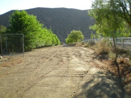
Y2 Vac Vic Aliso Canyon Rd Ave
Los Angeles-Long Beach-Glendale, CA
Parcel Map No 15237
3058-028-001
P M 198-64-65 LOT 1
Desertorbarrenland
Los Angeles
X
California
06037C0885G
1
2024
5.18 AC
2025
East LA County Outlying
910815
Los Angeles
DEMOGRAPHICS near Y2 Vac Vic Aliso Canyon Rd Ave
1 Mile
3 Mile
5 Mile
2024 Total Population
530
4,521
6,528
2029 Population
512
4,346
6,274
Pop Growth 2024-2029
(3.40%)
(3.87%)
(3.89%)
Average Age
46
45
45
2024 Total Households
196
1,633
2,336
HH Growth 2024-2029
(4.08%)
(4.16%)
(4.15%)
Median Household Inc
$97,321
$108,724
$111,250
Avg Household Size
2.60
2.70
2.70
2024 Avg HH Vehicles
3.00
3.00
3.00
Median Home Value
$709,134
$729,338
$735,739
Median Year Built
1986
1985
1985
Nearby Places
Map Layers
Map Styles
 Street
 Aerial
- Restaurants
- Banks
- Shops
- Fitness
- Groceries
PUBLIC TRANSPORTATION
COMMUTER RAIL
Vincent Grade/Acton (Antelope Valley Line - Southern California Regional Rail Authority (Metrolink))
DRIVE
WALK
Distance
Vincent Grade/Acton (Antelope Valley Line - Southern California Regional Rail Authority (Metrolink))
10 min
4.9 mi
AIRPORT
Bob Hope
DRIVE
WALK
Distance
Bob Hope
53 min
41.7 mi
Freight Ports
Port of Long Beach
DRIVE
WALK
Distance
Port of Long Beach
96 min
78.2 mi
Nearby Properties
Address
Land Use
TOTAL SIZE
Lot Size
Zoning
Address
Land Use
TOTAL SIZE
Lot Size
Zoning
134,189 SF
11.43 AC
LCM1
Address
Land Use
TOTAL SIZE
Lot Size
Zoning
8.71 AC
LCC3DP*
Address
Land Use
TOTAL SIZE
Lot Size
Zoning
39,654 SF
2.28 AC
C4
Address
Land Use
TOTAL SIZE
Lot Size
Zoning
4.22 AC
LCC3DP*
Address
Land Use
TOTAL SIZE
Lot Size
Zoning
14,000 SF
3.12 AC
LCC3DP*
Address
Land Use
TOTAL SIZE
Lot Size
Zoning
3,216 SF
0.52 AC
LCC3DP*
Address
Land Use
TOTAL SIZE
Lot Size
Zoning
2,497 SF
2.01 AC
LCC2*
Address
Land Use
TOTAL SIZE
Lot Size
Zoning
17,108 SF
1.80 AC
LCC4-A1100
Address
Land Use
TOTAL SIZE
Lot Size
Zoning
600 SF
1.92 AC
LCC4*
Address
Land Use
TOTAL SIZE
Lot Size
Zoning
7,500 SF
0.67 AC
LCC-RU
Address
Land Use
TOTAL SIZE
Lot Size
Zoning
2,628 SF
37.90 AC
LCA2 5
Address
Land Use
TOTAL SIZE
Lot Size
Zoning
22,014 SF
1.70 AC
LCA11*
Address
Land Use
TOTAL SIZE
Lot Size
Zoning
9,518 SF
0.67 AC
LCC4*
Address
Land Use
TOTAL SIZE
Lot Size
Zoning
14,893 SF
1.19 AC
LCA11*
Address
Land Use
TOTAL SIZE
Lot Size
Zoning
1.81 AC
LCC4*
Address
Land Use
TOTAL SIZE
Lot Size
Zoning
4,015 SF
18.14 AC
LCA21*
Address
Land Use
TOTAL SIZE
Lot Size
Zoning
2.90 AC
LCM1*
Address
Land Use
TOTAL SIZE
Lot Size
Zoning
7,379 SF
1.01 AC
LCA11*
Address
Land Use
TOTAL SIZE
Lot Size
Zoning
7.08 AC
LCM1*
Address
Land Use
TOTAL SIZE
Lot Size
Zoning
4,749 SF
3.21 AC
LCC4*
Address
Land Use
TOTAL SIZE
Lot Size
Zoning
1,954 SF
5.80 AC
LCM1-A21*
Address
Land Use
TOTAL SIZE
Lot Size
Zoning
8.58 AC
LCC2/LCA-1
Address
Land Use
TOTAL SIZE
Lot Size
Zoning
4.54 AC
LCC4*
Address
Land Use
TOTAL SIZE
Lot Size
Zoning
59.01 AC
LCA21*
Address
Land Use
TOTAL SIZE
Lot Size
Zoning
8.94 AC
LCA11*
Address
Land Use
TOTAL SIZE
Lot Size
Zoning
13,705 SF
3.08 AC
LCA21*
Address
Land Use
TOTAL SIZE
Lot Size
Zoning
1.89 AC
E1
Address
Land Use
TOTAL SIZE
Lot Size
Zoning
9.63 AC
LCR3-A1100
Address
Land Use
TOTAL SIZE
Lot Size
Zoning
744 SF
0.50 AC
LCA11*
Address
Land Use
TOTAL SIZE
Lot Size
Zoning
6,796 SF
0.35 AC
LCA110000*
The World's #1 Commercial Real Estate Marketplace
Connect with us
© 2026 CoStar Group
The information above has been obtained from sources believed reliable. While we do not doubt its accuracy we have not verified it and make no guarantee, warranty or representation about it. It is your responsibility to independently confirm its accuracy and completeness. Any projections, opinions, assumptions, or estimates used are for example only and do not represent the current or future performance of the property. The value of this transaction to you depends on tax and other factors which should be evaluated by your tax, financial, and legal advisors. You and your advisors should conduct a careful, independent investigation of the property to determine to your satisfaction the suitability of the property for your needs.