Property Record
Yeager St, Port Huron, MI 48060
Save to a Folder
{{folder.Name}}
{{folder.ListingIds.length}} Properties
{{folder.ListingIds.length}} Property
Create a New Folder
This Property Is For Sale
Property Detail
Yeager St
Detroit-Warren-Dearborn, MI
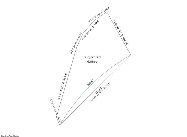
BEG N 60D 8M 22S E 1216.59' & N 16D 4M 50S E 320.52' FROM INT/SEC OF C/L OF YEAGER ST & INDIAN RESERVE LINE, TH N 16D 4M 50S E 669.80', TH N 25D 30M 35S E 143.1', TH N 40D 20M 35S E 145.6', TH N 55D 3M 35S E 146.4', TH S 28D 49M 56S E 452.78' TO A PT
28-174-0023-000
ST. CLAIR
Commercialacreage
Michigan
B-3
17,23,4
B and X Area of moderate flood hazard, usually the area between the limits of the 100-year and 500-year floods.
6.89 AC
2025
St Clair & Lapeer Counties
2025
Detroit
623000
NEARBY LISTINGS FOR SALE OR LEASE
DEMOGRAPHICS near Yeager St
1 mile
3 mile
5 mile
2025 Total Population
4,488
39,655
59,448
2030 Population
4,445
39,466
59,272
Pop Growth 2025-2030
(0.96%)
(0.48%)
(0.30%)
Average Age
41
41
42
2025 Total Households
1,780
16,621
24,620
HH Growth 2025-2030
(1.18%)
(0.55%)
(0.36%)
Median Household Inc
$49,422
$54,450
$59,263
Avg Household Size
2.40
2.30
2.30
2025 Avg HH Vehicles
2.00
2.00
2.00
Median Home Value
$160,968
$173,387
$182,667
Median Year Built
1958
1961
1969
Nearby Places
Map Layers
Map Styles
 Street
 Aerial
Layers
 Traffic
 Biking
Places
Listings with unknown addresses are not visible on the map
- Restaurants
- Banks
- Shops
- Fitness
- Groceries
PUBLIC TRANSPORTATION
COMMUTER RAIL
Port Huron Amtrak Station (Blue Water - Amtrak)
Drive
Walk
Distance
Port Huron Amtrak Station (Blue Water - Amtrak)
7 min
2.8 mi
Sarnia (Toronto - Sarnia - VIA Rail)
Drive
Walk
Distance
Sarnia (Toronto - Sarnia - VIA Rail)
15 min
6.9 mi
Freight Ports
Port of Toledo
Drive
Walk
Distance
Port of Toledo
144 min
121.3 mi
Nearby Properties
Address
Land Use
TOTAL SIZE
Lot Size
Zoning
Address
Land Use
TOTAL SIZE
Lot Size
Zoning
206,565 SF
22.08 AC
I
Address
Land Use
TOTAL SIZE
Lot Size
Zoning
183,833 SF
14.34 AC
O-1
Address
Land Use
TOTAL SIZE
Lot Size
Zoning
241,664 SF
50.15 AC
B-3
Address
Land Use
TOTAL SIZE
Lot Size
Zoning
27,675 SF
9.17 AC
C-2
Address
Land Use
TOTAL SIZE
Lot Size
Zoning
Address
Land Use
TOTAL SIZE
Lot Size
Zoning
88,524 SF
1.41 AC
CBD
Address
Land Use
TOTAL SIZE
Lot Size
Zoning
Address
Land Use
TOTAL SIZE
Lot Size
Zoning
83,563 SF
7.46 AC
CBD
Address
Land Use
TOTAL SIZE
Lot Size
Zoning
137,905 SF
17.26 AC
C-2
Address
Land Use
TOTAL SIZE
Lot Size
Zoning
173,584 SF
9.50 AC
M1
Address
Land Use
TOTAL SIZE
Lot Size
Zoning
Address
Land Use
TOTAL SIZE
Lot Size
Zoning
149,732 SF
12.48 AC
M1
Address
Land Use
TOTAL SIZE
Lot Size
Zoning
109,097 SF
6.47 AC
A2
Address
Land Use
TOTAL SIZE
Lot Size
Zoning
12.31 AC
C1
Address
Land Use
TOTAL SIZE
Lot Size
Zoning
40,690 SF
0.89 AC
CBD
Address
Land Use
TOTAL SIZE
Lot Size
Zoning
76,352 SF
4.88 AC
C1
Address
Land Use
TOTAL SIZE
Lot Size
Zoning
137,720 SF
12.04 AC
B-3
Address
Land Use
TOTAL SIZE
Lot Size
Zoning
123,394 SF
3.10 AC
A1
Address
Land Use
TOTAL SIZE
Lot Size
Zoning
84,625 SF
7.24 AC
C-2
Address
Land Use
TOTAL SIZE
Lot Size
Zoning
94,537 SF
12.63 AC
B-3
Address
Land Use
TOTAL SIZE
Lot Size
Zoning
112,566 SF
7.20 AC
B-3
Address
Land Use
TOTAL SIZE
Lot Size
Zoning
73,882 SF
6.50 AC
B-3
Address
Land Use
TOTAL SIZE
Lot Size
Zoning
39,547 SF
A1
Address
Land Use
TOTAL SIZE
Lot Size
Zoning
93,191 SF
6.20 AC
A1
Address
Land Use
TOTAL SIZE
Lot Size
Zoning
111,847 SF
13.79 AC
C-2
Address
Land Use
TOTAL SIZE
Lot Size
Zoning
33,810 SF
0.92 AC
CBD
Address
Land Use
TOTAL SIZE
Lot Size
Zoning
2.66 AC
Address
Land Use
TOTAL SIZE
Lot Size
Zoning
140,230 SF
7.90 AC
M1
Address
Land Use
TOTAL SIZE
Lot Size
Zoning
333,076 SF
23.19 AC
M2
Address
Land Use
TOTAL SIZE
Lot Size
Zoning
85,200 SF
4.23 AC
M1
The World's #1 Commercial Real Estate Marketplace
Connect with us
© 2026 CoStar Group
The information above has been obtained from sources believed reliable. While we do not doubt its accuracy we have not verified it and make no guarantee, warranty or representation about it. It is your responsibility to independently confirm its accuracy and completeness. Any projections, opinions, assumptions, or estimates used are for example only and do not represent the current or future performance of the property. The value of this transaction to you depends on tax and other factors which should be evaluated by your tax, financial, and legal advisors. You and your advisors should conduct a careful, independent investigation of the property to determine to your satisfaction the suitability of the property for your needs.