Property Record
Yucca Ct, Sparks, NV 89441
Property Detail
Yucca Ct
Reno, NV
PM 1299 LT B LESS TO STREET
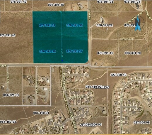
076-391-38
WASHOE
Residentialacreage
Nevada
GR
b
B and X Area of moderate flood hazard, usually the area between the limits of the 100-year and 500-year floods.
8.82 AC
0
N Outlying Washoe County
2026
Reno/Sparks
003519
NEARBY LISTINGS FOR SALE OR LEASE
DEMOGRAPHICS near Yucca Ct
1 mile
3 mile
5 mile
2025 Total Population
2,509
31,565
59,387
2030 Population
2,533
33,041
61,962
Pop Growth 2025-2030
+ 0.96%
+ 4.68%
+ 4.34%
Average Age
47
41
41
2025 Total Households
912
11,352
21,355
HH Growth 2025-2030
+ 0.99%
+ 4.70%
+ 4.35%
Median Household Inc
$140,659
$117,533
$118,653
Avg Household Size
2.70
2.80
2.80
2025 Avg HH Vehicles
2.00
2.00
2.00
Median Home Value
$773,461
$692,018
$670,404
Median Year Built
2006
2006
2005
Nearby Places
Map Layers
Map Styles
 Street
 Aerial
Layers
 Traffic
 Biking
Places
Listings with unknown addresses are not visible on the map
- Restaurants
- Banks
- Shops
- Fitness
- Groceries
PUBLIC TRANSPORTATION
AIRPORT
Reno/Tahoe International
Drive
Walk
Distance
Reno/Tahoe International
41 min
17.6 mi
Freight Ports
Port of Stockton
Drive
Walk
Distance
Port of Stockton
226 min
191.9 mi
SALE & LEASE HISTORY
LISTING DATE
SALE/LEASE

Jun 15, 2021
For Sale
Jul 09, 2020
For Sale
Nearby Properties
Address
Land Use
TOTAL SIZE
Lot Size
Zoning
Address
Land Use
TOTAL SIZE
Lot Size
Zoning
416,482 SF
21.84 AC
PD
Address
Land Use
TOTAL SIZE
Lot Size
Zoning
308,431 SF
20 AC
PD
Address
Land Use
TOTAL SIZE
Lot Size
Zoning
236,695 SF
8.66 AC
PD
Address
Land Use
TOTAL SIZE
Lot Size
Zoning
238,764 SF
7 AC
NC
Address
Land Use
TOTAL SIZE
Lot Size
Zoning
231,353 SF
11.52 AC
NUD
Address
Land Use
TOTAL SIZE
Lot Size
Zoning
209,527 SF
5.28 AC
NC
Address
Land Use
TOTAL SIZE
Lot Size
Zoning
160,562 SF
17.10 AC
I
Address
Land Use
TOTAL SIZE
Lot Size
Zoning
181,857 SF
8.19 AC
NUD
Address
Land Use
TOTAL SIZE
Lot Size
Zoning
13,874 SF
448.16 AC
PF
Address
Land Use
TOTAL SIZE
Lot Size
Zoning
112,215 SF
5.49 AC
NUD
Address
Land Use
TOTAL SIZE
Lot Size
Zoning
57,702 SF
5.27 AC
PD
Address
Land Use
TOTAL SIZE
Lot Size
Zoning
81,122 SF
8.44 AC
NUD
Address
Land Use
TOTAL SIZE
Lot Size
Zoning
58,299 SF
6.75 AC
PD
Address
Land Use
TOTAL SIZE
Lot Size
Zoning
102,137 SF
8.46 AC
NC
Address
Land Use
TOTAL SIZE
Lot Size
Zoning
54,237 SF
8 AC
PD
Address
Land Use
TOTAL SIZE
Lot Size
Zoning
34.89 AC
PD
Address
Land Use
TOTAL SIZE
Lot Size
Zoning
52,128 SF
6.70 AC
GC
Address
Land Use
TOTAL SIZE
Lot Size
Zoning
55,889 SF
9.87 AC
PSP
Address
Land Use
TOTAL SIZE
Lot Size
Zoning
51,736 SF
9.04 AC
PSP
Address
Land Use
TOTAL SIZE
Lot Size
Zoning
10,272 SF
6.94 AC
OS 12% / N
Address
Land Use
TOTAL SIZE
Lot Size
Zoning
39.12 AC
I
Address
Land Use
TOTAL SIZE
Lot Size
Zoning
11,061 SF
5 AC
NUD
Address
Land Use
TOTAL SIZE
Lot Size
Zoning
22.02 AC
PSP 4% / G
Address
Land Use
TOTAL SIZE
Lot Size
Zoning
14,266 SF
1.85 AC
PD
Address
Land Use
TOTAL SIZE
Lot Size
Zoning
63,015 SF
130.47 AC
NUD
Address
Land Use
TOTAL SIZE
Lot Size
Zoning
18.68 AC
PD
Address
Land Use
TOTAL SIZE
Lot Size
Zoning
8,489 SF
3.78 AC
NUD
Address
Land Use
TOTAL SIZE
Lot Size
Zoning
17.40 AC
PD
Address
Land Use
TOTAL SIZE
Lot Size
Zoning
17,906 SF
2.13 AC
PD
Address
Land Use
TOTAL SIZE
Lot Size
Zoning
10,431 SF
1.65 AC
GC
The World's #1 Commercial Real Estate Marketplace
Connect with us
© 2026 CoStar Group
The information above has been obtained from sources believed reliable. While we do not doubt its accuracy we have not verified it and make no guarantee, warranty or representation about it. It is your responsibility to independently confirm its accuracy and completeness. Any projections, opinions, assumptions, or estimates used are for example only and do not represent the current or future performance of the property. The value of this transaction to you depends on tax and other factors which should be evaluated by your tax, financial, and legal advisors. You and your advisors should conduct a careful, independent investigation of the property to determine to your satisfaction the suitability of the property for your needs.