Property Record
6575 Fisher Rd, Fayetteville, NC 28304


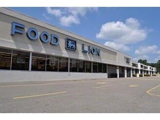
Property Detail
6575 Fisher Rd
9496-70-6211
STRICKLAND BRIDGE ASSOCIATES LO:1 SE:01 PL:0065-0087
Commercialnec
Cumberland
LC
North Carolina
B and X Area of moderate flood hazard, usually the area between the limits of the 100-year and 500-year floods.
1
2025
5.96 AC
2025
Southwest Fayetteville
003207
Fayetteville
51,449 SF
Fayetteville, NC
NEARBY LISTINGS FOR SALE OR LEASE
DEMOGRAPHICS near 6575 Fisher Rd
1 mile
3 mile
5 mile
2025 Total Population
7,153
50,704
141,210
2030 Population
7,122
50,643
141,272
Pop Growth 2025-2030
(0.43%)
(0.12%)
+ 0.04%
Average Age
36
36
36
2025 Total Households
2,522
19,397
55,712
HH Growth 2025-2030
(0.40%)
(0.04%)
+ 0.10%
Median Household Inc
$80,300
$69,785
$64,965
Avg Household Size
2.80
2.60
2.50
2025 Avg HH Vehicles
2.00
2.00
2.00
Median Home Value
$239,228
$224,846
$199,687
Median Year Built
1988
1989
1989
Nearby Places
Map Layers
Map Styles
 Street
 Aerial
Layers
 Traffic
 Biking
Places
Listings with unknown addresses are not visible on the map
- Restaurants
- Banks
- Shops
- Fitness
- Groceries
PUBLIC TRANSPORTATION
COMMUTER RAIL
Drive
Walk
Distance
18 min
9.0 mi
AIRPORT
Fayetteville Regional/Grannis Field
Drive
Walk
Distance
Fayetteville Regional/Grannis Field
17 min
10.1 mi
SALE & LEASE HISTORY
LISTING DATE
SALE/LEASE

Sep 23, 2016
For Sale
Feb 14, 2018
For Sale
Feb 12, 2018
For Lease
Feb 12, 2018
For Sale
Nearby Properties
Address
Land Use
TOTAL SIZE
Lot Size
Zoning
Address
Land Use
TOTAL SIZE
Lot Size
Zoning
64,137 SF
40.24 AC
OI
Address
Land Use
TOTAL SIZE
Lot Size
Zoning
161,719 SF
107.14 AC
RR
Address
Land Use
TOTAL SIZE
Lot Size
Zoning
2,049 SF
25.22 AC
MR5
Address
Land Use
TOTAL SIZE
Lot Size
Zoning
2,064 SF
26.91 AC
R6CZ
Address
Land Use
TOTAL SIZE
Lot Size
Zoning
56,747 SF
88.76 AC
AR
Address
Land Use
TOTAL SIZE
Lot Size
Zoning
2,370 SF
15.66 AC
PND
Address
Land Use
TOTAL SIZE
Lot Size
Zoning
5,136 SF
19.84 AC
SF6
Address
Land Use
TOTAL SIZE
Lot Size
Zoning
4,956 SF
11.26 AC
R5
Address
Land Use
TOTAL SIZE
Lot Size
Zoning
2,114 SF
20.70 AC
MR5
Address
Land Use
TOTAL SIZE
Lot Size
Zoning
66,637 SF
25.83 AC
RR
Address
Land Use
TOTAL SIZE
Lot Size
Zoning
26,016 SF
30.11 AC
SF10
Address
Land Use
TOTAL SIZE
Lot Size
Zoning
1,289 SF
37.83 AC
MR5
Address
Land Use
TOTAL SIZE
Lot Size
Zoning
203,515 SF
22.92 AC
CC
Address
Land Use
TOTAL SIZE
Lot Size
Zoning
58.63 AC
AR
Address
Land Use
TOTAL SIZE
Lot Size
Zoning
4,549 SF
29.20 AC
MR5
Address
Land Use
TOTAL SIZE
Lot Size
Zoning
139,767 SF
16 AC
CC
Address
Land Use
TOTAL SIZE
Lot Size
Zoning
54,706 SF
27.30 AC
R10
Address
Land Use
TOTAL SIZE
Lot Size
Zoning
53,457 SF
10.07 AC
MXD
Address
Land Use
TOTAL SIZE
Lot Size
Zoning
3.45 AC
CC-COMMUNI
Address
Land Use
TOTAL SIZE
Lot Size
Zoning
12,550 SF
6.87 AC
RR
Address
Land Use
TOTAL SIZE
Lot Size
Zoning
2,204 SF
5.88 AC
MR5
Address
Land Use
TOTAL SIZE
Lot Size
Zoning
4,956 SF
3.82 AC
R5
Address
Land Use
TOTAL SIZE
Lot Size
Zoning
2,540 SF
4.05 AC
MR5
Address
Land Use
TOTAL SIZE
Lot Size
Zoning
2,056 SF
5.99 AC
MR5
Address
Land Use
TOTAL SIZE
Lot Size
Zoning
7,704 SF
19.98 AC
MR5
Address
Land Use
TOTAL SIZE
Lot Size
Zoning
49,691 SF
7.09 AC
LC
Address
Land Use
TOTAL SIZE
Lot Size
Zoning
1,944 SF
6.51 AC
MR5C
Address
Land Use
TOTAL SIZE
Lot Size
Zoning
1,881 SF
15.18 AC
SF10
Address
Land Use
TOTAL SIZE
Lot Size
Zoning
10,420 SF
1.98 AC
LC
Address
Land Use
TOTAL SIZE
Lot Size
Zoning
3,040 SF
234.17 AC
AR
The World's #1 Commercial Real Estate Marketplace
Connect with us
© 2026 CoStar Group
The information above has been obtained from sources believed reliable. While we do not doubt its accuracy we have not verified it and make no guarantee, warranty or representation about it. It is your responsibility to independently confirm its accuracy and completeness. Any projections, opinions, assumptions, or estimates used are for example only and do not represent the current or future performance of the property. The value of this transaction to you depends on tax and other factors which should be evaluated by your tax, financial, and legal advisors. You and your advisors should conduct a careful, independent investigation of the property to determine to your satisfaction the suitability of the property for your needs.