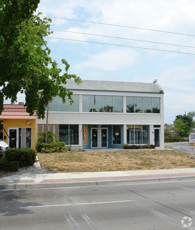
Property Record
400 N State Road 7, Plantation, FL 33311


NEARBY LISTINGS FOR SALE OR LEASE
Property Detail
400 N State Road 7
Fort Lauderdale-Pompano Beach-Sunrise, FL
Broward Estates Section 2
50-42-06-00-0200
BROWARD ESTATES SEC 2 34-19 B TR X N 100.30 OF W 100
Storesoffices
Broward
X
Florida
12011C0552J
x
2024
0.21 AC
2025
Fort Lauderdale
042900
South Florida
6,973 SF
DEMOGRAPHICS near 400 N State Road 7
1 Mile
3 Mile
5 Mile
2024 Total Population
17,087
171,992
447,254
2029 Population
17,041
171,377
448,823
Pop Growth 2024-2029
(0.27%)
(0.36%)
+ 0.35%
Average Age
39
38
40
2024 Total Households
5,392
60,092
178,982
HH Growth 2024-2029
(0.72%)
(0.57%)
+ 0.23%
Median Household Inc
$54,152
$46,417
$57,376
Avg Household Size
2.90
2.70
2.40
2024 Avg HH Vehicles
2.00
2.00
2.00
Median Home Value
$280,193
$279,712
$297,474
Median Year Built
1963
1971
1976
Nearby Places
Map Layers
Map Styles
 Street
 Aerial
- Restaurants
- Banks
- Shops
- Fitness
- Groceries
PUBLIC TRANSPORTATION
COMMUTER RAIL
Fort Lauderdale (Tri-County Commuter - South Florida Regional Transportation Authority (Tri-Rail))
DRIVE
WALK
Distance
Fort Lauderdale (Tri-County Commuter - South Florida Regional Transportation Authority (Tri-Rail))
9 min
2.7 mi
Fort Lauderdale/Hollywood International Airport (Tri-County Commuter - South Florida Regional Transportation Authority (Tri-Rail))
DRIVE
WALK
Distance
Fort Lauderdale/Hollywood International Airport (Tri-County Commuter - South Florida Regional Transportation Authority (Tri-Rail))
17 min
7.5 mi
AIRPORT
Fort Lauderdale/Hollywood International
DRIVE
WALK
Distance
Fort Lauderdale/Hollywood International
20 min
8.3 mi
Miami International
DRIVE
WALK
Distance
Miami International
50 min
33.8 mi
Palm Beach International
DRIVE
WALK
Distance
Palm Beach International
54 min
45.3 mi
SALE & LEASE HISTORY
LISTING DATE
SALE/LEASE

Nov 26, 2021
For Sale
Mar 30, 2017
For Sale
Mar 05, 2024
For Sale
Jun 03, 2024
For Sale
Aug 01, 2023
For Sale
Apr 12, 2017
For Sale
Apr 10, 2017
For Sale
Apr 07, 2017
For Sale
Apr 06, 2017
For Sale
Apr 05, 2017
For Sale
Nearby Properties
Address
Land Use
TOTAL SIZE
Lot Size
Zoning
Address
Land Use
TOTAL SIZE
Lot Size
Zoning
663,255 SF
3.15 AC
RAC-CC
Address
Land Use
TOTAL SIZE
Lot Size
Zoning
475,897 SF
14.91 AC
RAC-RTE
Address
Land Use
TOTAL SIZE
Lot Size
Zoning
409,340 SF
15.49 AC
RAC-RTE
Address
Land Use
TOTAL SIZE
Lot Size
Zoning
576,167 SF
27 AC
RAC-RTE
Address
Land Use
TOTAL SIZE
Lot Size
Zoning
346,662 SF
26.47 AC
RM-18
Address
Land Use
TOTAL SIZE
Lot Size
Zoning
416,469 SF
2.28 AC
M-PM
Address
Land Use
TOTAL SIZE
Lot Size
Zoning
278,398 SF
11.11 AC
RMM-25
Address
Land Use
TOTAL SIZE
Lot Size
Zoning
339,273 SF
20.48 AC
RM-16
Address
Land Use
TOTAL SIZE
Lot Size
Zoning
464,170 SF
43.19 AC
CF
Address
Land Use
TOTAL SIZE
Lot Size
Zoning
161,298 SF
31.25 AC
B-3
Address
Land Use
TOTAL SIZE
Lot Size
Zoning
289,523 SF
9.44 AC
B-HCS
Address
Land Use
TOTAL SIZE
Lot Size
Zoning
300,359 SF
11.76 AC
PRD-15.7Q
Address
Land Use
TOTAL SIZE
Lot Size
Zoning
309,879 SF
7.78 AC
TND-PUD
Address
Land Use
TOTAL SIZE
Lot Size
Zoning
262,844 SF
10.85 AC
B-FCC
Address
Land Use
TOTAL SIZE
Lot Size
Zoning
291,638 SF
15.08 AC
PRD-15Q
Address
Land Use
TOTAL SIZE
Lot Size
Zoning
321,043 SF
34.99 AC
CF-P
Address
Land Use
TOTAL SIZE
Lot Size
Zoning
327,948 SF
30.42 AC
CF-P
Address
Land Use
TOTAL SIZE
Lot Size
Zoning
307,727 SF
17.53 AC
I
Address
Land Use
TOTAL SIZE
Lot Size
Zoning
217,019 SF
10.62 AC
B-2
Address
Land Use
TOTAL SIZE
Lot Size
Zoning
692,139 SF
24.33 AC
RM-45
Address
Land Use
TOTAL SIZE
Lot Size
Zoning
281,912 SF
12.69 AC
B-4
Address
Land Use
TOTAL SIZE
Lot Size
Zoning
400,154 SF
9.69 AC
RM-45
Address
Land Use
TOTAL SIZE
Lot Size
Zoning
291,880 SF
10.33 AC
CF
Address
Land Use
TOTAL SIZE
Lot Size
Zoning
175,332 SF
4.05 AC
RAC-RTE
Address
Land Use
TOTAL SIZE
Lot Size
Zoning
108,908 SF
19.89 AC
CF-P
Address
Land Use
TOTAL SIZE
Lot Size
Zoning
319,321 SF
23.38 AC
CF
Address
Land Use
TOTAL SIZE
Lot Size
Zoning
285,942 SF
37.08 AC
CF
Address
Land Use
TOTAL SIZE
Lot Size
Zoning
269,917 SF
31.52 AC
CF
Address
Land Use
TOTAL SIZE
Lot Size
Zoning
331,834 SF
14.66 AC
CF
Address
Land Use
TOTAL SIZE
Lot Size
Zoning
112,765 SF
14.23 AC
CF
The World's #1 Commercial Real Estate Marketplace
Connect with us
© 2026 CoStar Group
The information above has been obtained from sources believed reliable. While we do not doubt its accuracy we have not verified it and make no guarantee, warranty or representation about it. It is your responsibility to independently confirm its accuracy and completeness. Any projections, opinions, assumptions, or estimates used are for example only and do not represent the current or future performance of the property. The value of this transaction to you depends on tax and other factors which should be evaluated by your tax, financial, and legal advisors. You and your advisors should conduct a careful, independent investigation of the property to determine to your satisfaction the suitability of the property for your needs.