Property Record
3359 Highway 356, Sautee Nacoochee, GA 30571

Save to a Folder
{{folder.Name}}
{{folder.ListingIds.length}} Properties
{{folder.ListingIds.length}} Property
Create a New Folder
Property Detail
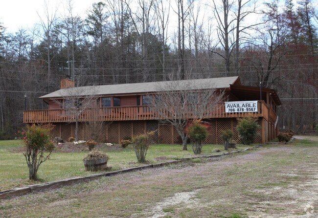
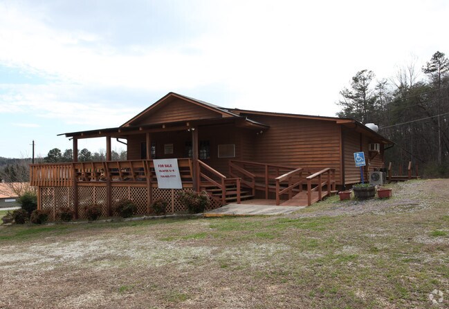
3359 Highway 356
Restaurantbuilding
LL13 LD6
C1
White
B and X Area of moderate flood hazard, usually the area between the limits of the 100-year and 500-year floods.
Georgia
2025
1.26 AC
2025
Georgia Northeast
950101
Other Market Areas
1,972 SF
055-035
NEARBY LISTINGS FOR SALE OR LEASE
-
-
View all Sautee Nacoochee listings for sale on LoopNet.com
DEMOGRAPHICS near 3359 Highway 356
1 mile
3 mile
5 mile
2025 Total Population
230
2,595
3,652
2030 Population
250
2,801
3,930
Pop Growth 2025-2030
+ 8.70%
+ 7.94%
+ 7.61%
Average Age
53
52
52
2025 Total Households
109
1,221
1,689
HH Growth 2025-2030
+ 8.26%
+ 7.78%
+ 7.40%
Median Household Inc
$74,999
$71,083
$70,099
Avg Household Size
2.10
2.10
2.20
2025 Avg HH Vehicles
2.00
2.00
2.00
Median Home Value
$373,809
$360,138
$352,614
Median Year Built
1990
1991
1991
Nearby Places
Map Layers
Map Styles
 Street
 Aerial
Layers
 Traffic
 Biking
Places
Listings with unknown addresses are not visible on the map
- Restaurants
- Banks
- Shops
- Fitness
- Groceries
SALE & LEASE HISTORY
LISTING DATE
SALE/LEASE

Sep 24, 2016
For Sale
May 05, 2023
For Sale
Jul 03, 2018
For Sale
Jan 19, 2017
For Sale
Nearby Properties
Address
Land Use
TOTAL SIZE
Lot Size
Zoning
Address
Land Use
TOTAL SIZE
Lot Size
Zoning
1,708 SF
200 AC
A1
Address
Land Use
TOTAL SIZE
Lot Size
Zoning
57,899 SF
1.77 AC
C3
Address
Land Use
TOTAL SIZE
Lot Size
Zoning
45,895 SF
3.50 AC
C3
Address
Land Use
TOTAL SIZE
Lot Size
Zoning
30,574 SF
5.59 AC
HM
Address
Land Use
TOTAL SIZE
Lot Size
Zoning
656 SF
29.67 AC
A1
Address
Land Use
TOTAL SIZE
Lot Size
Zoning
6,704 SF
3 AC
R4
Address
Land Use
TOTAL SIZE
Lot Size
Zoning
1,664 SF
1.64 AC
R4
Address
Land Use
TOTAL SIZE
Lot Size
Zoning
9,068 SF
1.69 AC
R3
Address
Land Use
TOTAL SIZE
Lot Size
Zoning
10,574 SF
0.85 AC
C1
Address
Land Use
TOTAL SIZE
Lot Size
Zoning
39,948 SF
1.99 AC
HM
Address
Land Use
TOTAL SIZE
Lot Size
Zoning
2,656 SF
0.83 AC
C3
Address
Land Use
TOTAL SIZE
Lot Size
Zoning
65,750 SF
7.51 AC
R1
Address
Land Use
TOTAL SIZE
Lot Size
Zoning
4,298 SF
5 AC
R3
Address
Land Use
TOTAL SIZE
Lot Size
Zoning
37,587 SF
2.09 AC
C2
Address
Land Use
TOTAL SIZE
Lot Size
Zoning
1,296 SF
165 AC
R1
Address
Land Use
TOTAL SIZE
Lot Size
Zoning
2,136 SF
4.04 AC
R4
Address
Land Use
TOTAL SIZE
Lot Size
Zoning
15,704 SF
1.26 AC
C3
Address
Land Use
TOTAL SIZE
Lot Size
Zoning
1,690 SF
2.31 AC
R3
Address
Land Use
TOTAL SIZE
Lot Size
Zoning
576 SF
2.69 AC
R4
Address
Land Use
TOTAL SIZE
Lot Size
Zoning
2,419 SF
2.94 AC
R4
Address
Land Use
TOTAL SIZE
Lot Size
Zoning
2,464 SF
22.17 AC
C2
Address
Land Use
TOTAL SIZE
Lot Size
Zoning
3,160 SF
0.46 AC
R4
Address
Land Use
TOTAL SIZE
Lot Size
Zoning
1,994 SF
6.76 AC
R1
Address
Land Use
TOTAL SIZE
Lot Size
Zoning
22,788 SF
1.20 AC
R1
Address
Land Use
TOTAL SIZE
Lot Size
Zoning
8,750 SF
1.85 AC
R1
Address
Land Use
TOTAL SIZE
Lot Size
Zoning
15,250 SF
10.30 AC
C3
Address
Land Use
TOTAL SIZE
Lot Size
Zoning
2,176 SF
2.59 AC
C1
Address
Land Use
TOTAL SIZE
Lot Size
Zoning
20,178 SF
2.40 AC
HM
Address
Land Use
TOTAL SIZE
Lot Size
Zoning
179.52 AC
R1
Address
Land Use
TOTAL SIZE
Lot Size
Zoning
10,175 SF
1.03 AC
HM
The World's #1 Commercial Real Estate Marketplace
Connect with us
© 2026 CoStar Group
The information above has been obtained from sources believed reliable. While we do not doubt its accuracy we have not verified it and make no guarantee, warranty or representation about it. It is your responsibility to independently confirm its accuracy and completeness. Any projections, opinions, assumptions, or estimates used are for example only and do not represent the current or future performance of the property. The value of this transaction to you depends on tax and other factors which should be evaluated by your tax, financial, and legal advisors. You and your advisors should conduct a careful, independent investigation of the property to determine to your satisfaction the suitability of the property for your needs.