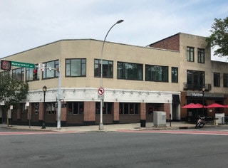
Property Record
147 Mamaroneck Ave, White Plains, NY 10601


Property Detail
147 Mamaroneck Ave
New York-Jersey City-White Plains, NY-NJ
WBL 3027 11
1700-125-084-00006-000-0001
WESTCHESTER
Retailwithmorethanonenonretailuse
New York
CB-1
1.001
2022
0.41 AC
2023
White Plains CBD
009400
Westchester/So Connecticut
13,150 SF
NEARBY LISTINGS FOR SALE OR LEASE
DEMOGRAPHICS near 147 Mamaroneck Ave
1 mile
3 mile
5 mile
2025 Total Population
44,595
114,916
221,478
2030 Population
45,726
116,862
224,227
Pop Growth 2025-2030
+ 2.54%
+ 1.69%
+ 1.24%
Average Age
42
43
42
2025 Total Households
19,581
44,498
80,164
HH Growth 2025-2030
+ 2.75%
+ 1.86%
+ 1.37%
Median Household Inc
$98,360
$127,529
$148,022
Avg Household Size
2.20
2.40
2.60
2025 Avg HH Vehicles
1.00
2.00
2.00
Median Home Value
$486,386
$689,157
$783,398
Median Year Built
1965
1961
1959
Nearby Places
Map Layers
Map Styles
 Street
 Aerial
Layers
 Traffic
 Biking
Places
Listings with unknown addresses are not visible on the map
- Restaurants
- Banks
- Shops
- Fitness
- Groceries
PUBLIC TRANSPORTATION
COMMUTER RAIL
White Plains Station (Harlem Line - Metro-North Commuter Railroad Company (Metro-North))
Drive
Walk
Distance
White Plains Station (Harlem Line - Metro-North Commuter Railroad Company (Metro-North))
2 min
16 min
0.8 mi
North White Plains Station (Harlem Line - Metro-North Commuter Railroad Company (Metro-North))
Drive
Walk
Distance
North White Plains Station (Harlem Line - Metro-North Commuter Railroad Company (Metro-North))
3 min
1.8 mi
AIRPORT
Westchester County
Drive
Walk
Distance
Westchester County
11 min
7.5 mi
LaGuardia
Drive
Walk
Distance
LaGuardia
40 min
23.2 mi
John F Kennedy International
Drive
Walk
Distance
John F Kennedy International
46 min
30.7 mi
Freight Ports
NY - Red Hook Container Terminal
Drive
Walk
Distance
NY - Red Hook Container Terminal
54 min
33.7 mi
SALE & LEASE HISTORY
LISTING DATE
SALE/LEASE

Sep 24, 2016
For Lease
May 22, 2024
For Lease
Jul 26, 2019
For Lease
Dec 19, 2022
For Lease
Nearby Properties
Address
Land Use
TOTAL SIZE
Lot Size
Zoning
Address
Land Use
TOTAL SIZE
Lot Size
Zoning
Address
Land Use
TOTAL SIZE
Lot Size
Zoning
4.45 AC
B
Address
Land Use
TOTAL SIZE
Lot Size
Zoning
381,836 SF
16.68 AC
A3
Address
Land Use
TOTAL SIZE
Lot Size
Zoning
75.87 AC
R-20
Address
Land Use
TOTAL SIZE
Lot Size
Zoning
66 AC
R-20
Address
Land Use
TOTAL SIZE
Lot Size
Zoning
237,313 SF
22.67 AC
A1
Address
Land Use
TOTAL SIZE
Lot Size
Zoning
16.22 AC
UR
Address
Land Use
TOTAL SIZE
Lot Size
Zoning
22.44 AC
R-20
Address
Land Use
TOTAL SIZE
Lot Size
Zoning
1,975 SF
13.80 AC
CA
Address
Land Use
TOTAL SIZE
Lot Size
Zoning
84,450 SF
3.19 AC
B
Address
Land Use
TOTAL SIZE
Lot Size
Zoning
29.42 AC
PUD
Address
Land Use
TOTAL SIZE
Lot Size
Zoning
10.90 AC
UR
Address
Land Use
TOTAL SIZE
Lot Size
Zoning
3.16 AC
Address
Land Use
TOTAL SIZE
Lot Size
Zoning
64.41 AC
R-20
Address
Land Use
TOTAL SIZE
Lot Size
Zoning
108,367 SF
5.57 AC
AA1
Address
Land Use
TOTAL SIZE
Lot Size
Zoning
1,200 SF
21.21 AC
R-20
Address
Land Use
TOTAL SIZE
Lot Size
Zoning
7.98 AC
M-14
Address
Land Use
TOTAL SIZE
Lot Size
Zoning
0.58 AC
B
Address
Land Use
TOTAL SIZE
Lot Size
Zoning
48,267 SF
11.04 AC
A2 A
Address
Land Use
TOTAL SIZE
Lot Size
Zoning
7.98 AC
CA
Address
Land Use
TOTAL SIZE
Lot Size
Zoning
11.21 AC
R-20
Address
Land Use
TOTAL SIZE
Lot Size
Zoning
5.43 AC
R-40
Address
Land Use
TOTAL SIZE
Lot Size
Zoning
320 SF
5.38 AC
LI
Address
Land Use
TOTAL SIZE
Lot Size
Zoning
1,348 SF
5.67 AC
CA
Address
Land Use
TOTAL SIZE
Lot Size
Zoning
6.09 AC
DS
Address
Land Use
TOTAL SIZE
Lot Size
Zoning
1,630 SF
2.64 AC
LOB
Address
Land Use
TOTAL SIZE
Lot Size
Zoning
122.37 AC
Address
Land Use
TOTAL SIZE
Lot Size
Zoning
2,100 SF
24.12 AC
A3
Address
Land Use
TOTAL SIZE
Lot Size
Zoning
9.73 AC
OB-1
Address
Land Use
TOTAL SIZE
Lot Size
Zoning
68,616 SF
3.11 AC
The World's #1 Commercial Real Estate Marketplace
Connect with us
© 2026 CoStar Group
The information above has been obtained from sources believed reliable. While we do not doubt its accuracy we have not verified it and make no guarantee, warranty or representation about it. It is your responsibility to independently confirm its accuracy and completeness. Any projections, opinions, assumptions, or estimates used are for example only and do not represent the current or future performance of the property. The value of this transaction to you depends on tax and other factors which should be evaluated by your tax, financial, and legal advisors. You and your advisors should conduct a careful, independent investigation of the property to determine to your satisfaction the suitability of the property for your needs.