Property Record
1266 Orchard Rd, Montgomery, IL 60538
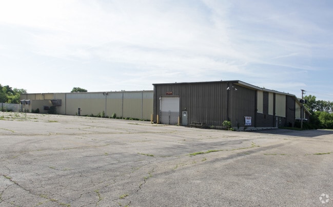
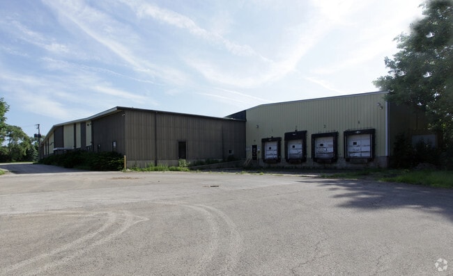

Property Detail
1266 Orchard Rd
Chicago-Naperville-Elgin, IL-IN
PART SW 1/4 SEC 30-38-8
15-30-326-029
Kane
Farms
Illinois
B and X Area of moderate flood hazard, usually the area between the limits of the 100-year and 500-year floods.
8.59 AC
2024
I-88 West
2024
Chicago
854002
NEARBY LISTINGS FOR SALE OR LEASE
DEMOGRAPHICS near 1266 Orchard Rd
1 mile
3 mile
5 mile
2025 Total Population
3,188
68,660
182,831
2030 Population
3,252
70,676
187,932
Pop Growth 2025-2030
+ 2.01%
+ 2.94%
+ 2.79%
Average Age
42
38
38
2025 Total Households
1,155
23,095
60,293
HH Growth 2025-2030
+ 1.99%
+ 2.84%
+ 2.84%
Median Household Inc
$76,219
$85,230
$86,582
Avg Household Size
2.70
2.90
2.90
2025 Avg HH Vehicles
2.00
2.00
2.00
Median Home Value
$277,906
$265,692
$271,138
Median Year Built
1978
1977
1979
Nearby Places
Map Layers
Map Styles
 Street
 Aerial
Transit
 Traffic
 Biking
Places
Listings with unknown addresses are not visible on the map
- Restaurants
- Banks
- Shops
- Fitness
- Groceries
PUBLIC TRANSPORTATION
COMMUTER RAIL
Aurora Station (Burlington Northern-Santa Fe Railway Line - Northeast Illinois Regional Commuter Railroad (Metra))
Drive
Walk
Distance
Aurora Station (Burlington Northern-Santa Fe Railway Line - Northeast Illinois Regional Commuter Railroad (Metra))
9 min
4.6 mi
AIRPORT
Chicago O'Hare International
Drive
Walk
Distance
Chicago O'Hare International
59 min
41.9 mi
Freight Ports
Port Milwaukee
Drive
Walk
Distance
Port Milwaukee
140 min
113.7 mi
Nearby Properties
Address
Land Use
TOTAL SIZE
Lot Size
Zoning
Address
Land Use
TOTAL SIZE
Lot Size
Zoning
19.80 AC
Address
Land Use
TOTAL SIZE
Lot Size
Zoning
350.78 AC
Address
Land Use
TOTAL SIZE
Lot Size
Zoning
989,724 SF
49.41 AC
Address
Land Use
TOTAL SIZE
Lot Size
Zoning
56.02 AC
Address
Land Use
TOTAL SIZE
Lot Size
Zoning
218,020 SF
21.35 AC
Address
Land Use
TOTAL SIZE
Lot Size
Zoning
169,918 SF
20 AC
Address
Land Use
TOTAL SIZE
Lot Size
Zoning
428,544 SF
41.38 AC
Address
Land Use
TOTAL SIZE
Lot Size
Zoning
97,136 SF
6.08 AC
Address
Land Use
TOTAL SIZE
Lot Size
Zoning
9.86 AC
Address
Land Use
TOTAL SIZE
Lot Size
Zoning
259,140 SF
18.05 AC
Address
Land Use
TOTAL SIZE
Lot Size
Zoning
366,503 SF
11.88 AC
Address
Land Use
TOTAL SIZE
Lot Size
Zoning
136,900 SF
3.63 AC
Address
Land Use
TOTAL SIZE
Lot Size
Zoning
56.13 AC
Address
Land Use
TOTAL SIZE
Lot Size
Zoning
217,505 SF
17.50 AC
Address
Land Use
TOTAL SIZE
Lot Size
Zoning
3.85 AC
Address
Land Use
TOTAL SIZE
Lot Size
Zoning
581,048 SF
37.29 AC
Address
Land Use
TOTAL SIZE
Lot Size
Zoning
34,822 SF
136.74 AC
Address
Land Use
TOTAL SIZE
Lot Size
Zoning
17.35 AC
Address
Land Use
TOTAL SIZE
Lot Size
Zoning
60,275 SF
3 AC
Address
Land Use
TOTAL SIZE
Lot Size
Zoning
139,494 SF
13.73 AC
Address
Land Use
TOTAL SIZE
Lot Size
Zoning
287,902 SF
3.31 AC
Address
Land Use
TOTAL SIZE
Lot Size
Zoning
146,500 SF
8.65 AC
Address
Land Use
TOTAL SIZE
Lot Size
Zoning
84,870 SF
5.28 AC
Address
Land Use
TOTAL SIZE
Lot Size
Zoning
84,884 SF
5.23 AC
Address
Land Use
TOTAL SIZE
Lot Size
Zoning
98,716 SF
3.06 AC
Address
Land Use
TOTAL SIZE
Lot Size
Zoning
118,498 SF
11.28 AC
Address
Land Use
TOTAL SIZE
Lot Size
Zoning
119,937 SF
1.08 AC
Address
Land Use
TOTAL SIZE
Lot Size
Zoning
159,966 SF
3.90 AC
The World's #1 Commercial Real Estate Marketplace
Connect with us
© 2026 CoStar Group
The information above has been obtained from sources believed reliable. While we do not doubt its accuracy we have not verified it and make no guarantee, warranty or representation about it. It is your responsibility to independently confirm its accuracy and completeness. Any projections, opinions, assumptions, or estimates used are for example only and do not represent the current or future performance of the property. The value of this transaction to you depends on tax and other factors which should be evaluated by your tax, financial, and legal advisors. You and your advisors should conduct a careful, independent investigation of the property to determine to your satisfaction the suitability of the property for your needs.