Property Record
241 Medical Plz, Michigan City, IN 46360
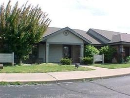


Property Detail
241 Medical Plz
46-01-29-261-026.000-022
42-01-29-261-026 MEDICAL PLAZA BUILDING 1 - UNIT D - 241 & 16.66% UND INTEREST IN COMMON AREA TIF ASSMT #51
Officebuilding
La Porte
B and X Area of moderate flood hazard, usually the area between the limits of the 100-year and 500-year floods.
Indiana
2024
0.03 AC
2025
South Bend/Elkhart
043000
Other Market Areas
1,260 SF
Michigan City-La Porte, IN
NEARBY LISTINGS FOR SALE OR LEASE
DEMOGRAPHICS near 241 Medical Plz
1 mile
3 mile
5 mile
2025 Total Population
8,157
32,187
42,858
2030 Population
8,300
32,166
42,950
Pop Growth 2025-2030
+ 1.75%
(0.07%)
+ 0.21%
Average Age
39
42
42
2025 Total Households
3,433
12,966
17,545
HH Growth 2025-2030
+ 1.86%
(0.14%)
+ 0.21%
Median Household Inc
$48,048
$53,191
$55,989
Avg Household Size
2.30
2.20
2.20
2025 Avg HH Vehicles
2.00
2.00
2.00
Median Home Value
$144,906
$152,275
$165,038
Median Year Built
1949
1959
1963
Nearby Places
Map Layers
Map Styles
 Street
 Aerial
Layers
 Traffic
 Biking
Places
Listings with unknown addresses are not visible on the map
- Restaurants
- Banks
- Shops
- Fitness
- Groceries
PUBLIC TRANSPORTATION
COMMUTER RAIL
11Th St. (Michigan City) (South Shore Line - Northern Indiana Commuter Transportation District (South Shore Line))
Drive
Walk
Distance
11Th St. (Michigan City) (South Shore Line - Northern Indiana Commuter Transportation District (South Shore Line))
2 min
12 min
0.7 mi
Carroll Avenue (Michigan City) Station (South Shore Line - Northern Indiana Commuter Transportation District (South Shore Line))
Drive
Walk
Distance
Carroll Avenue (Michigan City) Station (South Shore Line - Northern Indiana Commuter Transportation District (South Shore Line))
6 min
2.1 mi
Freight Ports
Port Milwaukee
Drive
Walk
Distance
Port Milwaukee
183 min
143.1 mi
Nearby Properties
Address
Land Use
TOTAL SIZE
Lot Size
Zoning
Address
Land Use
TOTAL SIZE
Lot Size
Zoning
87,360 SF
34.37 AC
Address
Land Use
TOTAL SIZE
Lot Size
Zoning
391,582 SF
46.06 AC
Address
Land Use
TOTAL SIZE
Lot Size
Zoning
136,799 SF
7.36 AC
Address
Land Use
TOTAL SIZE
Lot Size
Zoning
34,691 SF
10.66 AC
Address
Land Use
TOTAL SIZE
Lot Size
Zoning
41,672 SF
23.23 AC
Address
Land Use
TOTAL SIZE
Lot Size
Zoning
59,466 SF
16.38 AC
Address
Land Use
TOTAL SIZE
Lot Size
Zoning
41,030 SF
24.13 AC
Address
Land Use
TOTAL SIZE
Lot Size
Zoning
79,706 SF
7.50 AC
Address
Land Use
TOTAL SIZE
Lot Size
Zoning
12,510 SF
2.25 AC
Address
Land Use
TOTAL SIZE
Lot Size
Zoning
22,934 SF
15.21 AC
Address
Land Use
TOTAL SIZE
Lot Size
Zoning
33,230 SF
5.83 AC
Address
Land Use
TOTAL SIZE
Lot Size
Zoning
112,125 SF
18.28 AC
Address
Land Use
TOTAL SIZE
Lot Size
Zoning
29,332 SF
17.27 AC
Address
Land Use
TOTAL SIZE
Lot Size
Zoning
22,800 SF
20 AC
Address
Land Use
TOTAL SIZE
Lot Size
Zoning
1,200 SF
33.69 AC
Address
Land Use
TOTAL SIZE
Lot Size
Zoning
20,703 SF
8.97 AC
Address
Land Use
TOTAL SIZE
Lot Size
Zoning
33,872 SF
4.03 AC
Address
Land Use
TOTAL SIZE
Lot Size
Zoning
28,662 SF
3.85 AC
Address
Land Use
TOTAL SIZE
Lot Size
Zoning
56,638 SF
8.02 AC
Address
Land Use
TOTAL SIZE
Lot Size
Zoning
27,240 SF
2.19 AC
Address
Land Use
TOTAL SIZE
Lot Size
Zoning
20,046 SF
4.81 AC
Address
Land Use
TOTAL SIZE
Lot Size
Zoning
50,743 SF
9.45 AC
Address
Land Use
TOTAL SIZE
Lot Size
Zoning
68,122 SF
46.25 AC
Address
Land Use
TOTAL SIZE
Lot Size
Zoning
30,336 SF
10.63 AC
Address
Land Use
TOTAL SIZE
Lot Size
Zoning
819 SF
6.07 AC
Address
Land Use
TOTAL SIZE
Lot Size
Zoning
64,000 SF
8.61 AC
Address
Land Use
TOTAL SIZE
Lot Size
Zoning
22,523 SF
0.31 AC
Address
Land Use
TOTAL SIZE
Lot Size
Zoning
4,060 SF
4.66 AC
Address
Land Use
TOTAL SIZE
Lot Size
Zoning
55,576 SF
3.98 AC
Address
Land Use
TOTAL SIZE
Lot Size
Zoning
81,960 SF
7.54 AC
The World's #1 Commercial Real Estate Marketplace
Connect with us
© 2026 CoStar Group
The information above has been obtained from sources believed reliable. While we do not doubt its accuracy we have not verified it and make no guarantee, warranty or representation about it. It is your responsibility to independently confirm its accuracy and completeness. Any projections, opinions, assumptions, or estimates used are for example only and do not represent the current or future performance of the property. The value of this transaction to you depends on tax and other factors which should be evaluated by your tax, financial, and legal advisors. You and your advisors should conduct a careful, independent investigation of the property to determine to your satisfaction the suitability of the property for your needs.