Property Record
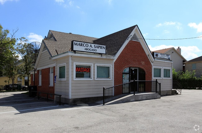
5912 Irvington Blvd, Houston, TX 77009


NEARBY LISTINGS FOR SALE OR LEASE
Property Detail
5912 Irvington Blvd
Houston-The Woodlands-Sugar Land, TX
Lindale Park Sec 1
0660630040044
Harris
Sfr
Texas
X
0.27 AC
48201C0680L
Inner Loop/Heights
1,730 SF
Houston
DEMOGRAPHICS near 5912 Irvington Blvd
1 Mile
3 Mile
5 Mile
2024 Total Population
15,658
144,826
412,744
2029 Population
16,113
150,043
427,533
Pop Growth 2024-2029
+ 2.91%
+ 3.60%
+ 3.58%
Average Age
39
38
37
2024 Total Households
5,563
55,620
166,268
HH Growth 2024-2029
+ 2.88%
+ 3.75%
+ 3.90%
Median Household Inc
$51,359
$50,740
$66,537
Avg Household Size
2.80
2.50
2.40
2024 Avg HH Vehicles
2.00
2.00
2.00
Median Home Value
$241,781
$287,452
$330,404
Median Year Built
1952
1963
1982
Nearby Places
Map Layers
Map Styles
 Street
 Aerial
- Restaurants
- Banks
- Shops
- Fitness
- Groceries
PUBLIC TRANSPORTATION
TRANSIT/SUBWAY
Melbourne / North Lindale (METRORAIL RED LINE - Metropolitan Transit Authority of Harris County, Redline - Metropolitan Transit Authority of Harris County)
DRIVE
WALK
Distance
Melbourne / North Lindale (METRORAIL RED LINE - Metropolitan Transit Authority of Harris County, Redline - Metropolitan Transit Authority of Harris County)
1 min
14 min
0.7 mi
Lindale Park (METRORAIL RED LINE - Metropolitan Transit Authority of Harris County, Redline - Metropolitan Transit Authority of Harris County)
DRIVE
WALK
Distance
Lindale Park (METRORAIL RED LINE - Metropolitan Transit Authority of Harris County, Redline - Metropolitan Transit Authority of Harris County)
2 min
15 min
0.8 mi
COMMUTER RAIL
Houston (Sunset Limited - Amtrak)
DRIVE
WALK
Distance
Houston (Sunset Limited - Amtrak)
8 min
4.6 mi
AIRPORT
George Bush Intcntl/Houston
DRIVE
WALK
Distance
George Bush Intcntl/Houston
20 min
16.1 mi
William P Hobby
DRIVE
WALK
Distance
William P Hobby
29 min
17.4 mi
Freight Ports
Port of Houston
DRIVE
WALK
Distance
Port of Houston
17 min
11.1 mi
SALE & LEASE HISTORY
LISTING DATE
SALE/LEASE

Sep 28, 2016
For Lease
Feb 13, 2018
For Lease
Apr 12, 2018
For Lease
Nearby Properties
Address
Land Use
TOTAL SIZE
Lot Size
Zoning
Address
Land Use
TOTAL SIZE
Lot Size
Zoning
453,456 SF
3.11 AC
Address
Land Use
TOTAL SIZE
Lot Size
Zoning
519,374 SF
6.18 AC
Address
Land Use
TOTAL SIZE
Lot Size
Zoning
788,433 SF
5.09 AC
Address
Land Use
TOTAL SIZE
Lot Size
Zoning
474,326 SF
43.16 AC
Address
Land Use
TOTAL SIZE
Lot Size
Zoning
314,489 SF
1.84 AC
Address
Land Use
TOTAL SIZE
Lot Size
Zoning
432,691 SF
3.26 AC
Address
Land Use
TOTAL SIZE
Lot Size
Zoning
261,312 SF
1.81 AC
Address
Land Use
TOTAL SIZE
Lot Size
Zoning
593,265 SF
3.73 AC
Address
Land Use
TOTAL SIZE
Lot Size
Zoning
522,454 SF
6.63 AC
Address
Land Use
TOTAL SIZE
Lot Size
Zoning
569,030 SF
4.92 AC
Address
Land Use
TOTAL SIZE
Lot Size
Zoning
587,156 SF
4.40 AC
Address
Land Use
TOTAL SIZE
Lot Size
Zoning
440,577 SF
4.13 AC
Address
Land Use
TOTAL SIZE
Lot Size
Zoning
87,179 SF
4.13 AC
Address
Land Use
TOTAL SIZE
Lot Size
Zoning
263,475 SF
7.90 AC
Address
Land Use
TOTAL SIZE
Lot Size
Zoning
186,808 SF
4.73 AC
Address
Land Use
TOTAL SIZE
Lot Size
Zoning
198,770 SF
2.10 AC
Address
Land Use
TOTAL SIZE
Lot Size
Zoning
276,332 SF
6.05 AC
Address
Land Use
TOTAL SIZE
Lot Size
Zoning
498,726 SF
4.97 AC
Address
Land Use
TOTAL SIZE
Lot Size
Zoning
302,826 SF
2.87 AC
Address
Land Use
TOTAL SIZE
Lot Size
Zoning
545,628 SF
19.41 AC
Address
Land Use
TOTAL SIZE
Lot Size
Zoning
224,741 SF
10.75 AC
Address
Land Use
TOTAL SIZE
Lot Size
Zoning
213,548 SF
16.98 AC
Address
Land Use
TOTAL SIZE
Lot Size
Zoning
160,849 SF
2.14 AC
Address
Land Use
TOTAL SIZE
Lot Size
Zoning
200,902 SF
4.36 AC
Address
Land Use
TOTAL SIZE
Lot Size
Zoning
105,268 SF
7.26 AC
Address
Land Use
TOTAL SIZE
Lot Size
Zoning
211,564 SF
1.20 AC
Address
Land Use
TOTAL SIZE
Lot Size
Zoning
188,582 SF
17.94 AC
Address
Land Use
TOTAL SIZE
Lot Size
Zoning
64,521 SF
3.91 AC
Address
Land Use
TOTAL SIZE
Lot Size
Zoning
110,721 SF
0.94 AC
Address
Land Use
TOTAL SIZE
Lot Size
Zoning
171,166 SF
6.87 AC
The World's #1 Commercial Real Estate Marketplace
Connect with us
© 2025 CoStar Group
The information above has been obtained from sources believed reliable. While we do not doubt its accuracy we have not verified it and make no guarantee, warranty or representation about it. It is your responsibility to independently confirm its accuracy and completeness. Any projections, opinions, assumptions, or estimates used are for example only and do not represent the current or future performance of the property. The value of this transaction to you depends on tax and other factors which should be evaluated by your tax, financial, and legal advisors. You and your advisors should conduct a careful, independent investigation of the property to determine to your satisfaction the suitability of the property for your needs.