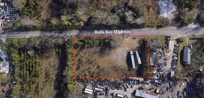
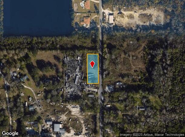
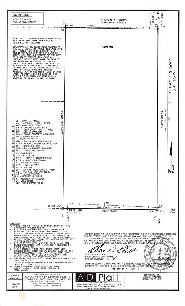
Property Record
0 Bulls Bay Hwy, Jacksonville, FL 32220
Current Lease Availabilities
NEARBY LISTINGS FOR SALE OR LEASE
Property Detail
0 Bulls Bay Hwy
Jacksonville, FL
Section Land
004809-0000
10-2S-25E .95 PT GOVT LOT 14 BEING PARCEL 7 RECD O/R 19737-242(EX PT IN RD)
Industrialacreage
Duval
X
Florida
12031C0333H
14
2025
0.93 AC
2026
Northwest Jacksonville
011901
Jacksonville (Florida)
DEMOGRAPHICS near 0 Bulls Bay Hwy
1 Mile
3 Mile
5 Mile
2024 Total Population
2,002
20,759
90,750
2029 Population
2,119
21,783
95,397
Pop Growth 2024-2029
+ 5.84%
+ 4.93%
+ 5.12%
Average Age
41
40
38
2024 Total Households
768
7,817
34,845
HH Growth 2024-2029
+ 5.99%
+ 5.01%
+ 5.23%
Median Household Inc
$49,341
$61,113
$52,325
Avg Household Size
2.60
2.60
2.50
2024 Avg HH Vehicles
2.00
2.00
2.00
Median Home Value
$216,000
$176,409
$176,764
Median Year Built
1989
1982
1974
Nearby Places
Map Layers
Map Styles
 Street
 Aerial
- Restaurants
- Banks
- Shops
- Fitness
- Groceries
PUBLIC TRANSPORTATION
COMMUTER RAIL
Jacksonville (Silver Meteor - Amtrak, Silver Star - Amtrak)
DRIVE
WALK
Distance
Jacksonville (Silver Meteor - Amtrak, Silver Star - Amtrak)
14 min
7.3 mi
AIRPORT
Jacksonville International
DRIVE
WALK
Distance
Jacksonville International
28 min
17.8 mi
Freight Ports
Jacksonville Port
DRIVE
WALK
Distance
Jacksonville Port
24 min
13.8 mi
Nearby Properties
Address
Land Use
TOTAL SIZE
Lot Size
Zoning
Address
Land Use
TOTAL SIZE
Lot Size
Zoning
973,797 SF
105.79 AC
PUD
Address
Land Use
TOTAL SIZE
Lot Size
Zoning
600,857 SF
38.14 AC
IL
Address
Land Use
TOTAL SIZE
Lot Size
Zoning
874,178 SF
46.91 AC
PBF-2
Address
Land Use
TOTAL SIZE
Lot Size
Zoning
465,664 SF
21.27 AC
IL
Address
Land Use
TOTAL SIZE
Lot Size
Zoning
397,865 SF
42 AC
IL
Address
Land Use
TOTAL SIZE
Lot Size
Zoning
321,547 SF
17.17 AC
PUD
Address
Land Use
TOTAL SIZE
Lot Size
Zoning
222,138 SF
13.18 AC
IL
Address
Land Use
TOTAL SIZE
Lot Size
Zoning
449,367 SF
26.16 AC
PUD
Address
Land Use
TOTAL SIZE
Lot Size
Zoning
414,674 SF
21.03 AC
PUD
Address
Land Use
TOTAL SIZE
Lot Size
Zoning
505,748 SF
94.71 AC
IL
Address
Land Use
TOTAL SIZE
Lot Size
Zoning
392,050 SF
50.22 AC
PUD
Address
Land Use
TOTAL SIZE
Lot Size
Zoning
311,382 SF
18.57 AC
PUD
Address
Land Use
TOTAL SIZE
Lot Size
Zoning
270,762 SF
39.15 AC
PUD
Address
Land Use
TOTAL SIZE
Lot Size
Zoning
509,686 SF
43.32 AC
IL
Address
Land Use
TOTAL SIZE
Lot Size
Zoning
240,050 SF
28.53 AC
IBP
Address
Land Use
TOTAL SIZE
Lot Size
Zoning
481,686 SF
43.54 AC
IL
Address
Land Use
TOTAL SIZE
Lot Size
Zoning
216,022 SF
15.36 AC
PUD
Address
Land Use
TOTAL SIZE
Lot Size
Zoning
274,925 SF
19.70 AC
PUD
Address
Land Use
TOTAL SIZE
Lot Size
Zoning
236,224 SF
14.13 AC
PUD
Address
Land Use
TOTAL SIZE
Lot Size
Zoning
161,001 SF
10.32 AC
IL
Address
Land Use
TOTAL SIZE
Lot Size
Zoning
162,283 SF
14.29 AC
IL
Address
Land Use
TOTAL SIZE
Lot Size
Zoning
214,392 SF
11.29 AC
PUD
Address
Land Use
TOTAL SIZE
Lot Size
Zoning
196,548 SF
13.05 AC
PUD
Address
Land Use
TOTAL SIZE
Lot Size
Zoning
114,316 SF
20.57 AC
IL
Address
Land Use
TOTAL SIZE
Lot Size
Zoning
279,053 SF
21.03 AC
IBP
Address
Land Use
TOTAL SIZE
Lot Size
Zoning
167,854 SF
8.01 AC
IL
Address
Land Use
TOTAL SIZE
Lot Size
Zoning
171,413 SF
10.39 AC
PUD
Address
Land Use
TOTAL SIZE
Lot Size
Zoning
140,558 SF
8.52 AC
PUD
Address
Land Use
TOTAL SIZE
Lot Size
Zoning
165,608 SF
10.93 AC
PUD
Address
Land Use
TOTAL SIZE
Lot Size
Zoning
269,178 SF
129.93 AC
PBF-2
The World's #1 Commercial Real Estate Marketplace
Connect with us
© 2026 CoStar Group
The information above has been obtained from sources believed reliable. While we do not doubt its accuracy we have not verified it and make no guarantee, warranty or representation about it. It is your responsibility to independently confirm its accuracy and completeness. Any projections, opinions, assumptions, or estimates used are for example only and do not represent the current or future performance of the property. The value of this transaction to you depends on tax and other factors which should be evaluated by your tax, financial, and legal advisors. You and your advisors should conduct a careful, independent investigation of the property to determine to your satisfaction the suitability of the property for your needs.