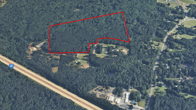
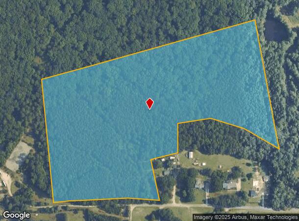
Property Record
4548 Nc Highway 87 N, Durham, NC 27707
This Property Is For Sale
NEARBY LISTINGS FOR SALE OR LEASE
Property Detail
4548 Nc Highway 87 N
Raleigh/Durham
Property Of John W. Brown
Durham-Chapel Hill, NC
Orange
9890564576
North Carolina
Sfr
25.05 AC
X
Orange County
3710989000M
DEMOGRAPHICS near 4548 Nc Highway 87 N
1 Mile
3 Mile
5 Mile
2024 Total Population
2,434
44,376
130,834
2029 Population
2,532
46,101
136,552
Pop Growth 2024-2029
+ 4.03%
+ 3.89%
+ 4.37%
Average Age
41
40
37
2024 Total Households
785
19,655
53,030
HH Growth 2024-2029
+ 4.20%
+ 4.21%
+ 4.91%
Median Household Inc
$181,488
$94,879
$90,104
Avg Household Size
2.80
2.20
2.20
2024 Avg HH Vehicles
2.00
2.00
2.00
Median Home Value
$763,985
$626,240
$584,348
Median Year Built
1994
1992
1991
Nearby Places
Map Layers
Map Styles
 Street
 Aerial
- Restaurants
- Banks
- Shops
- Fitness
- Groceries
PUBLIC TRANSPORTATION
COMMUTER RAIL
Durham Amtrak Station (Carolinian - Amtrak, Piedmont - Amtrak)
DRIVE
WALK
Distance
Durham Amtrak Station (Carolinian - Amtrak, Piedmont - Amtrak)
17 min
9.2 mi
AIRPORT
Raleigh-Durham International
DRIVE
WALK
Distance
Raleigh-Durham International
27 min
18.2 mi
Freight Ports
Virginia Port Authority - Richmond
DRIVE
WALK
Distance
Virginia Port Authority - Richmond
179 min
154.5 mi
Nearby Properties
Address
Land Use
TOTAL SIZE
Lot Size
Zoning
Address
Land Use
TOTAL SIZE
Lot Size
Zoning
216,220 SF
3.70 AC
CSD-C
Address
Land Use
TOTAL SIZE
Lot Size
Zoning
85,220 SF
20.34 AC
CSD-S1
Address
Land Use
TOTAL SIZE
Lot Size
Zoning
116,223 SF
34.65 AC
Address
Land Use
TOTAL SIZE
Lot Size
Zoning
244,609 SF
2.72 AC
Address
Land Use
TOTAL SIZE
Lot Size
Zoning
26,448 SF
22.07 AC
CSD-S1
Address
Land Use
TOTAL SIZE
Lot Size
Zoning
575,091 SF
3.21 AC
Address
Land Use
TOTAL SIZE
Lot Size
Zoning
24,183 SF
60.28 AC
PDR 9.280
Address
Land Use
TOTAL SIZE
Lot Size
Zoning
80,120 SF
101.81 AC
Address
Land Use
TOTAL SIZE
Lot Size
Zoning
419,416 SF
38.99 AC
CSD-S1
Address
Land Use
TOTAL SIZE
Lot Size
Zoning
10,680 SF
33.33 AC
PDR 4.110
Address
Land Use
TOTAL SIZE
Lot Size
Zoning
287,718 SF
4.97 AC
Address
Land Use
TOTAL SIZE
Lot Size
Zoning
150,677 SF
2.93 AC
Address
Land Use
TOTAL SIZE
Lot Size
Zoning
106,812 SF
19.25 AC
Address
Land Use
TOTAL SIZE
Lot Size
Zoning
22,038 SF
24.63 AC
CSD-S2
Address
Land Use
TOTAL SIZE
Lot Size
Zoning
12,585 SF
57.79 AC
PDR 6.420
Address
Land Use
TOTAL SIZE
Lot Size
Zoning
25,016 SF
31.87 AC
CSD-S1
Address
Land Use
TOTAL SIZE
Lot Size
Zoning
6,720 SF
32.22 AC
PDR 4.000
Address
Land Use
TOTAL SIZE
Lot Size
Zoning
5,286 SF
32.32 AC
RS-M
Address
Land Use
TOTAL SIZE
Lot Size
Zoning
30,869 SF
20.01 AC
CSD-S2
Address
Land Use
TOTAL SIZE
Lot Size
Zoning
144,619 SF
3.22 AC
Address
Land Use
TOTAL SIZE
Lot Size
Zoning
17,202 SF
36.96 AC
RS-M
Address
Land Use
TOTAL SIZE
Lot Size
Zoning
5,788 SF
4.56 AC
CSD-S1
Address
Land Use
TOTAL SIZE
Lot Size
Zoning
6,522 SF
12.95 AC
RU-M
Address
Land Use
TOTAL SIZE
Lot Size
Zoning
30,300 SF
13.83 AC
Address
Land Use
TOTAL SIZE
Lot Size
Zoning
258,730 SF
3.66 AC
Address
Land Use
TOTAL SIZE
Lot Size
Zoning
71,680 SF
20.17 AC
R5CCC
Address
Land Use
TOTAL SIZE
Lot Size
Zoning
121,500 SF
37.15 AC
Address
Land Use
TOTAL SIZE
Lot Size
Zoning
95,924 SF
30.93 AC
Address
Land Use
TOTAL SIZE
Lot Size
Zoning
28,272 SF
21.12 AC
OI2R4
Address
Land Use
TOTAL SIZE
Lot Size
Zoning
17,640 SF
11.51 AC
R4R5C
The World's #1 Commercial Real Estate Marketplace
Connect with us
© 2025 CoStar Group
The information above has been obtained from sources believed reliable. While we do not doubt its accuracy we have not verified it and make no guarantee, warranty or representation about it. It is your responsibility to independently confirm its accuracy and completeness. Any projections, opinions, assumptions, or estimates used are for example only and do not represent the current or future performance of the property. The value of this transaction to you depends on tax and other factors which should be evaluated by your tax, financial, and legal advisors. You and your advisors should conduct a careful, independent investigation of the property to determine to your satisfaction the suitability of the property for your needs.