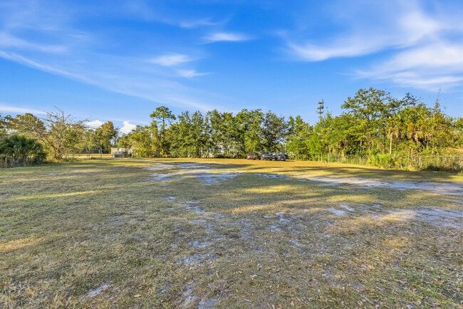
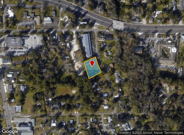
Property Record
0 Leslie Rd, Jacksonville, FL 32244
Current Lease Availabilities
NEARBY LISTINGS FOR SALE OR LEASE
Property Detail
0 Leslie Rd
Jacksonville, FL
Haley, S S/D
097924-0020
20-71 18-3S-26E .65 HALEYS SUBDIVISION LOT 19, PT LOT 20 RECD O/R 20309-1378 BEING PARCEL 1
Shipyard
Duval
X
Florida
12031C0526J
19,20
2025
0.62 AC
2026
Riverside
013526
Jacksonville (Florida)
DEMOGRAPHICS near 0 Leslie Rd
1 Mile
3 Mile
5 Mile
2024 Total Population
10,235
82,997
185,317
2029 Population
10,970
88,053
196,653
Pop Growth 2024-2029
+ 7.18%
+ 6.09%
+ 6.12%
Average Age
40
38
38
2024 Total Households
4,164
32,610
74,221
HH Growth 2024-2029
+ 7.52%
+ 6.41%
+ 6.43%
Median Household Inc
$53,322
$61,734
$62,168
Avg Household Size
2.40
2.50
2.40
2024 Avg HH Vehicles
2.00
2.00
2.00
Median Home Value
$231,640
$241,839
$256,105
Median Year Built
1977
1978
1980
Nearby Places
Map Layers
Map Styles
 Street
 Aerial
- Restaurants
- Banks
- Shops
- Fitness
- Groceries
PUBLIC TRANSPORTATION
AIRPORT
Jacksonville International
DRIVE
WALK
Distance
Jacksonville International
34 min
23.4 mi
Freight Ports
Jacksonville Port
DRIVE
WALK
Distance
Jacksonville Port
24 min
13.4 mi
Nearby Properties
Address
Land Use
TOTAL SIZE
Lot Size
Zoning
Address
Land Use
TOTAL SIZE
Lot Size
Zoning
246,982 SF
24.84 AC
PUD
Address
Land Use
TOTAL SIZE
Lot Size
Zoning
402,240 SF
20.66 AC
PUD
Address
Land Use
TOTAL SIZE
Lot Size
Zoning
355,124 SF
18.80 AC
PUD
Address
Land Use
TOTAL SIZE
Lot Size
Zoning
184,092 SF
21.69 AC
CCG-1
Address
Land Use
TOTAL SIZE
Lot Size
Zoning
179,916 SF
12.19 AC
RMD-D
Address
Land Use
TOTAL SIZE
Lot Size
Zoning
188,666 SF
17.76 AC
PUD
Address
Land Use
TOTAL SIZE
Lot Size
Zoning
416,674 SF
18.38 AC
RMD-D
Address
Land Use
TOTAL SIZE
Lot Size
Zoning
203,724 SF
14.71 AC
RMD-D
Address
Land Use
TOTAL SIZE
Lot Size
Zoning
224,893 SF
13.51 AC
RMD-D
Address
Land Use
TOTAL SIZE
Lot Size
Zoning
309,137 SF
20.09 AC
RMD-D
Address
Land Use
TOTAL SIZE
Lot Size
Zoning
272,076 SF
54.84 AC
PUD
Address
Land Use
TOTAL SIZE
Lot Size
Zoning
188,578 SF
13.44 AC
RMD-D
Address
Land Use
TOTAL SIZE
Lot Size
Zoning
228,290 SF
12.65 AC
RMD-D
Address
Land Use
TOTAL SIZE
Lot Size
Zoning
277,225 SF
11.72 AC
RMD-D
Address
Land Use
TOTAL SIZE
Lot Size
Zoning
96,314 SF
21.05 AC
CCG-1
Address
Land Use
TOTAL SIZE
Lot Size
Zoning
206,513 SF
9.83 AC
RMD-D
Address
Land Use
TOTAL SIZE
Lot Size
Zoning
231,044 SF
10.94 AC
RMD-D
Address
Land Use
TOTAL SIZE
Lot Size
Zoning
137,636 SF
9.73 AC
RMD-D
Address
Land Use
TOTAL SIZE
Lot Size
Zoning
171,412 SF
16.44 AC
RMD-D
Address
Land Use
TOTAL SIZE
Lot Size
Zoning
70,460 SF
1.66 AC
CCG-2
Address
Land Use
TOTAL SIZE
Lot Size
Zoning
229,441 SF
17.48 AC
PUD
Address
Land Use
TOTAL SIZE
Lot Size
Zoning
152,768 SF
9.66 AC
RMD-D
Address
Land Use
TOTAL SIZE
Lot Size
Zoning
67,581 SF
24.24 AC
PUD
Address
Land Use
TOTAL SIZE
Lot Size
Zoning
113,479 SF
7.32 AC
PUD
Address
Land Use
TOTAL SIZE
Lot Size
Zoning
103,833 SF
19.32 AC
PUD
Address
Land Use
TOTAL SIZE
Lot Size
Zoning
159,337 SF
11.09 AC
RMD-D
Address
Land Use
TOTAL SIZE
Lot Size
Zoning
209,238 SF
10.31 AC
RMD-D
Address
Land Use
TOTAL SIZE
Lot Size
Zoning
193,478 SF
10.13 AC
RMD-D
Address
Land Use
TOTAL SIZE
Lot Size
Zoning
187,612 SF
20.16 AC
PUD
Address
Land Use
TOTAL SIZE
Lot Size
Zoning
85,238 SF
3.90 AC
CCG-2
The World's #1 Commercial Real Estate Marketplace
Connect with us
© 2026 CoStar Group
The information above has been obtained from sources believed reliable. While we do not doubt its accuracy we have not verified it and make no guarantee, warranty or representation about it. It is your responsibility to independently confirm its accuracy and completeness. Any projections, opinions, assumptions, or estimates used are for example only and do not represent the current or future performance of the property. The value of this transaction to you depends on tax and other factors which should be evaluated by your tax, financial, and legal advisors. You and your advisors should conduct a careful, independent investigation of the property to determine to your satisfaction the suitability of the property for your needs.