No Photo
Property Record
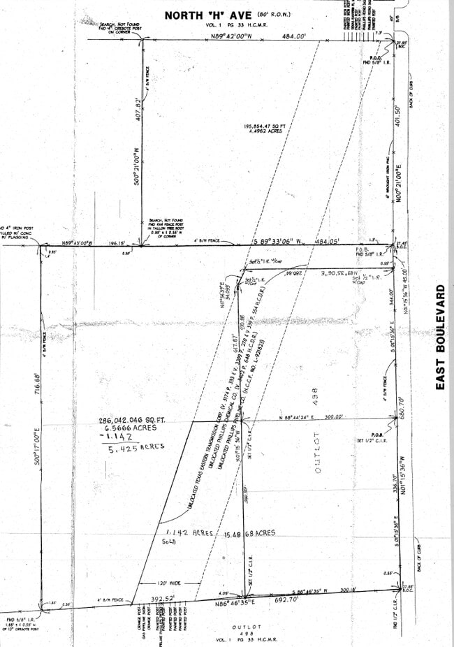
0 N H St, Deer Park, TX 77536

NEARBY LISTINGS FOR SALE OR LEASE
Property Detail
0 N H St
Houston-The Woodlands-Sugar Land, TX
La Porte Outlots
0231420000498
LT 498 LA PORTE OUTLOTS
Commercialacreage
Harris
X
Texas
48201C0940M
498
2024
4.50 AC
2025
Gulf Freeway/Pasadena
342700
Houston
DEMOGRAPHICS near 0 N H St
1 Mile
3 Mile
5 Mile
2024 Total Population
9,090
68,460
124,497
2029 Population
9,186
69,716
126,828
Pop Growth 2024-2029
+ 1.06%
+ 1.83%
+ 1.87%
Average Age
38
38
38
2024 Total Households
3,047
23,883
43,302
HH Growth 2024-2029
+ 1.02%
+ 1.83%
+ 1.83%
Median Household Inc
$108,300
$81,350
$77,141
Avg Household Size
2.90
2.80
2.80
2024 Avg HH Vehicles
2.00
2.00
2.00
Median Home Value
$258,513
$216,442
$209,894
Median Year Built
1987
1984
1983
Nearby Places
Map Layers
Map Styles
 Street
 Aerial
- Restaurants
- Banks
- Shops
- Fitness
- Groceries
PUBLIC TRANSPORTATION
AIRPORT
William P Hobby
DRIVE
WALK
Distance
William P Hobby
29 min
14.3 mi
George Bush Intcntl/Houston
DRIVE
WALK
Distance
George Bush Intcntl/Houston
43 min
32.7 mi
Freight Ports
Port of Houston
DRIVE
WALK
Distance
Port of Houston
25 min
15.6 mi
SALE & LEASE HISTORY
LISTING DATE
SALE/LEASE

Feb 11, 2022
For Sale
Nearby Properties
Address
Land Use
TOTAL SIZE
Lot Size
Zoning
Address
Land Use
TOTAL SIZE
Lot Size
Zoning
55.98 AC
Address
Land Use
TOTAL SIZE
Lot Size
Zoning
900,000 SF
42.88 AC
Address
Land Use
TOTAL SIZE
Lot Size
Zoning
767,630 SF
41.71 AC
Address
Land Use
TOTAL SIZE
Lot Size
Zoning
1,120,800 SF
35.24 AC
Address
Land Use
TOTAL SIZE
Lot Size
Zoning
711,094 SF
35.47 AC
Address
Land Use
TOTAL SIZE
Lot Size
Zoning
411,864 SF
12.61 AC
Address
Land Use
TOTAL SIZE
Lot Size
Zoning
562,760 SF
21.90 AC
Address
Land Use
TOTAL SIZE
Lot Size
Zoning
319,549 SF
20.70 AC
Address
Land Use
TOTAL SIZE
Lot Size
Zoning
371,097 SF
10.32 AC
Address
Land Use
TOTAL SIZE
Lot Size
Zoning
Address
Land Use
TOTAL SIZE
Lot Size
Zoning
414,900 SF
25.29 AC
Address
Land Use
TOTAL SIZE
Lot Size
Zoning
403,572 SF
24.68 AC
Address
Land Use
TOTAL SIZE
Lot Size
Zoning
371,072 SF
19.71 AC
Address
Land Use
TOTAL SIZE
Lot Size
Zoning
135,331 SF
5 AC
Address
Land Use
TOTAL SIZE
Lot Size
Zoning
45.18 AC
Address
Land Use
TOTAL SIZE
Lot Size
Zoning
359,223 SF
17.24 AC
Address
Land Use
TOTAL SIZE
Lot Size
Zoning
26.28 AC
Address
Land Use
TOTAL SIZE
Lot Size
Zoning
369,855 SF
21.68 AC
Address
Land Use
TOTAL SIZE
Lot Size
Zoning
356,565 SF
18.07 AC
Address
Land Use
TOTAL SIZE
Lot Size
Zoning
26.32 AC
Address
Land Use
TOTAL SIZE
Lot Size
Zoning
330,030 SF
20.14 AC
Address
Land Use
TOTAL SIZE
Lot Size
Zoning
Address
Land Use
TOTAL SIZE
Lot Size
Zoning
162,015 SF
10.49 AC
Address
Land Use
TOTAL SIZE
Lot Size
Zoning
110.78 AC
Address
Land Use
TOTAL SIZE
Lot Size
Zoning
275,853 SF
14.42 AC
Address
Land Use
TOTAL SIZE
Lot Size
Zoning
147,671 SF
17.84 AC
Address
Land Use
TOTAL SIZE
Lot Size
Zoning
185,745 SF
13.98 AC
Address
Land Use
TOTAL SIZE
Lot Size
Zoning
175.54 AC
Address
Land Use
TOTAL SIZE
Lot Size
Zoning
429,340 SF
19.61 AC
Address
Land Use
TOTAL SIZE
Lot Size
Zoning
236,158 SF
14.87 AC
The World's #1 Commercial Real Estate Marketplace
Connect with us
© 2025 CoStar Group
The information above has been obtained from sources believed reliable. While we do not doubt its accuracy we have not verified it and make no guarantee, warranty or representation about it. It is your responsibility to independently confirm its accuracy and completeness. Any projections, opinions, assumptions, or estimates used are for example only and do not represent the current or future performance of the property. The value of this transaction to you depends on tax and other factors which should be evaluated by your tax, financial, and legal advisors. You and your advisors should conduct a careful, independent investigation of the property to determine to your satisfaction the suitability of the property for your needs.