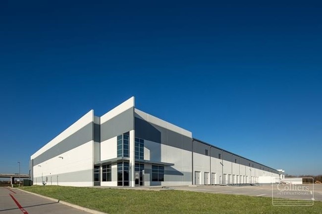
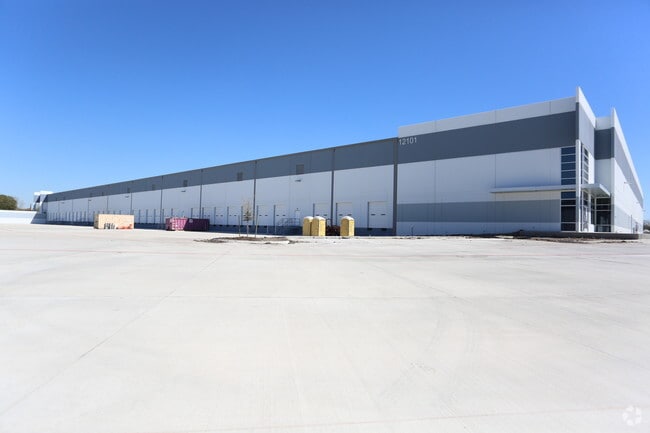
Property Record
0 S Mclain Blvd W, Houston, TX 77071
Property Detail
0 S Mclain Blvd W
1370400000001
RES A GATEWAY SOUTHWEST INDUSTRIAL PARK R/P
Warehouse
HARRIS
C and X Area of minimal flood hazard, usually depicted on FIRMs as above the 500-year flood level.
Texas
2024
10.47 AC
2025
Hwy 59/Hwy 90 (Alt)
423401
Houston
217,000 SF
Houston-Pasadena-The Woodlands, TX
NEARBY LISTINGS FOR SALE OR LEASE
DEMOGRAPHICS near 0 S Mclain Blvd W
1 mile
3 mile
5 mile
2025 Total Population
9,391
142,176
401,369
2030 Population
9,938
153,656
435,824
Pop Growth 2025-2030
+ 5.82%
+ 8.07%
+ 8.58%
Average Age
39
38
38
2025 Total Households
3,238
49,698
140,796
HH Growth 2025-2030
+ 6.05%
+ 8.20%
+ 8.80%
Median Household Inc
$60,648
$60,178
$60,829
Avg Household Size
2.90
2.80
2.80
2025 Avg HH Vehicles
2.00
2.00
2.00
Median Home Value
$207,515
$243,716
$262,009
Median Year Built
1980
1979
1979
Nearby Places
Map Layers
Map Styles
 Street
 Aerial
Layers
 Traffic
 Biking
Places
Listings with unknown addresses are not visible on the map
- Restaurants
- Banks
- Shops
- Fitness
- Groceries
PUBLIC TRANSPORTATION
AIRPORT
William P Hobby
Drive
Walk
Distance
William P Hobby
31 min
18.8 mi
George Bush Intcntl/Houston
Drive
Walk
Distance
George Bush Intcntl/Houston
47 min
39.0 mi
Freight Ports
Port of Houston
Drive
Walk
Distance
Port of Houston
33 min
20.8 mi
SALE & LEASE HISTORY
LISTING DATE
SALE/LEASE

Aug 04, 2017
For Lease
Nearby Properties
Address
Land Use
TOTAL SIZE
Lot Size
Zoning
Address
Land Use
TOTAL SIZE
Lot Size
Zoning
257,051 SF
64.85 AC
Address
Land Use
TOTAL SIZE
Lot Size
Zoning
552,900 SF
27.86 AC
Address
Land Use
TOTAL SIZE
Lot Size
Zoning
967,659 SF
75.03 AC
Address
Land Use
TOTAL SIZE
Lot Size
Zoning
344,620 SF
53.65 AC
STHQZ
Address
Land Use
TOTAL SIZE
Lot Size
Zoning
32,520 SF
34.98 AC
Address
Land Use
TOTAL SIZE
Lot Size
Zoning
35.85 AC
Address
Land Use
TOTAL SIZE
Lot Size
Zoning
305,512 SF
13.74 AC
Address
Land Use
TOTAL SIZE
Lot Size
Zoning
428,538 SF
45.50 AC
Address
Land Use
TOTAL SIZE
Lot Size
Zoning
93,310 SF
13.41 AC
Address
Land Use
TOTAL SIZE
Lot Size
Zoning
534,800 SF
33.43 AC
Address
Land Use
TOTAL SIZE
Lot Size
Zoning
176,377 SF
40.41 AC
SM
Address
Land Use
TOTAL SIZE
Lot Size
Zoning
Address
Land Use
TOTAL SIZE
Lot Size
Zoning
382,505 SF
21.68 AC
Address
Land Use
TOTAL SIZE
Lot Size
Zoning
456,076 SF
19.09 AC
Address
Land Use
TOTAL SIZE
Lot Size
Zoning
1,712 SF
17.93 AC
SM
Address
Land Use
TOTAL SIZE
Lot Size
Zoning
490,720 SF
26.78 AC
S
Address
Land Use
TOTAL SIZE
Lot Size
Zoning
304,006 SF
11.14 AC
Address
Land Use
TOTAL SIZE
Lot Size
Zoning
Address
Land Use
TOTAL SIZE
Lot Size
Zoning
383,515 SF
12.61 AC
Address
Land Use
TOTAL SIZE
Lot Size
Zoning
391,473 SF
17.11 AC
Address
Land Use
TOTAL SIZE
Lot Size
Zoning
186,759 SF
42.60 AC
Address
Land Use
TOTAL SIZE
Lot Size
Zoning
52,502 SF
13.60 AC
XYS
Address
Land Use
TOTAL SIZE
Lot Size
Zoning
18.23 AC
Address
Land Use
TOTAL SIZE
Lot Size
Zoning
434,744 SF
16.74 AC
Address
Land Use
TOTAL SIZE
Lot Size
Zoning
39.26 AC
Address
Land Use
TOTAL SIZE
Lot Size
Zoning
9.10 AC
Address
Land Use
TOTAL SIZE
Lot Size
Zoning
24.49 AC
QSY
Address
Land Use
TOTAL SIZE
Lot Size
Zoning
240,000 SF
12.45 AC
Address
Land Use
TOTAL SIZE
Lot Size
Zoning
256,810 SF
22.65 AC
Address
Land Use
TOTAL SIZE
Lot Size
Zoning
21.84 AC
QSY
The World's #1 Commercial Real Estate Marketplace
Connect with us
© 2026 CoStar Group
The information above has been obtained from sources believed reliable. While we do not doubt its accuracy we have not verified it and make no guarantee, warranty or representation about it. It is your responsibility to independently confirm its accuracy and completeness. Any projections, opinions, assumptions, or estimates used are for example only and do not represent the current or future performance of the property. The value of this transaction to you depends on tax and other factors which should be evaluated by your tax, financial, and legal advisors. You and your advisors should conduct a careful, independent investigation of the property to determine to your satisfaction the suitability of the property for your needs.